Morecambe & Heysham, Lancashire, Summer
After a thunderstorm, you need to get those vast and expansive views.
After a thunderstorm, you need to get those vast and expansive views.
On the Saturday, the Met Office issued a Yellow Warning of thunderstorms and torrential downpours. This was very much needed as temperatures were starting to creep up to the mid 20’s again with 90%+ humidity.
If there’s one thing a thunderstorm is really good at it’s clearing the atmosphere. So, on the Sunday, we decided that solid hike along the Morecambe Bay coast, from Morecambe to Heysham and back, was needed. The views across the bay to Cumbria and the Lake District fells are always welcome. Plus, we knew we would have limited time before the next load of thunderstorms arrived.
I decided to equip relatively minimally; just my camera, Sony 28–70 and Vivitar “Series 1” 70–210mm for those super tight and zoomed in compositions.
The views, and the weather, were glorious.
All photos taken on my Sony α7ii using my Sony FE 28–70mm f3.5–5.6 OSS and Vivitar “Series 1” 70–210mm f2.8–4.0 zoom lenses. RAWs developed in Lightroom for iPad using RNI Films’ Portra 160 film emulation, then a little bit of finalisation in Affinity Photo 2 for iPad.
Morecambe & Heysham, Lancashire, Summer by Ian Cylkowski is licensed under CC BY-NC-SA 4.0![]()
![]()
![]()
![]()
Want sweeping and expansive views for mountains in the distance? Morecambe Bay is where you need to be. Anywhere with access to the Bay will do, but for this walk we chose the town of Morecambe itself.
This is the 14 m tall Hook Beacon, signalling the location of West End Gardens at Morecambe Bay. It was conceived by Broadbent Studio in collaboration with local school pupils.
A man and his dog, watching the world go by.
We started the walk 1-hour after low tide, so the sea was still miles out. Families and couples alike were enjoying the sensation of wet sand on their feet and sea air in their faces.
I decided to equip my 70–210mm lens for some super-zoomed in compositions across the bay to Cumbria.
A lovely mural that I can never resist taking a shot of.
Nice and clear, the Coniston Fells in the Lake District, 25 miles away.
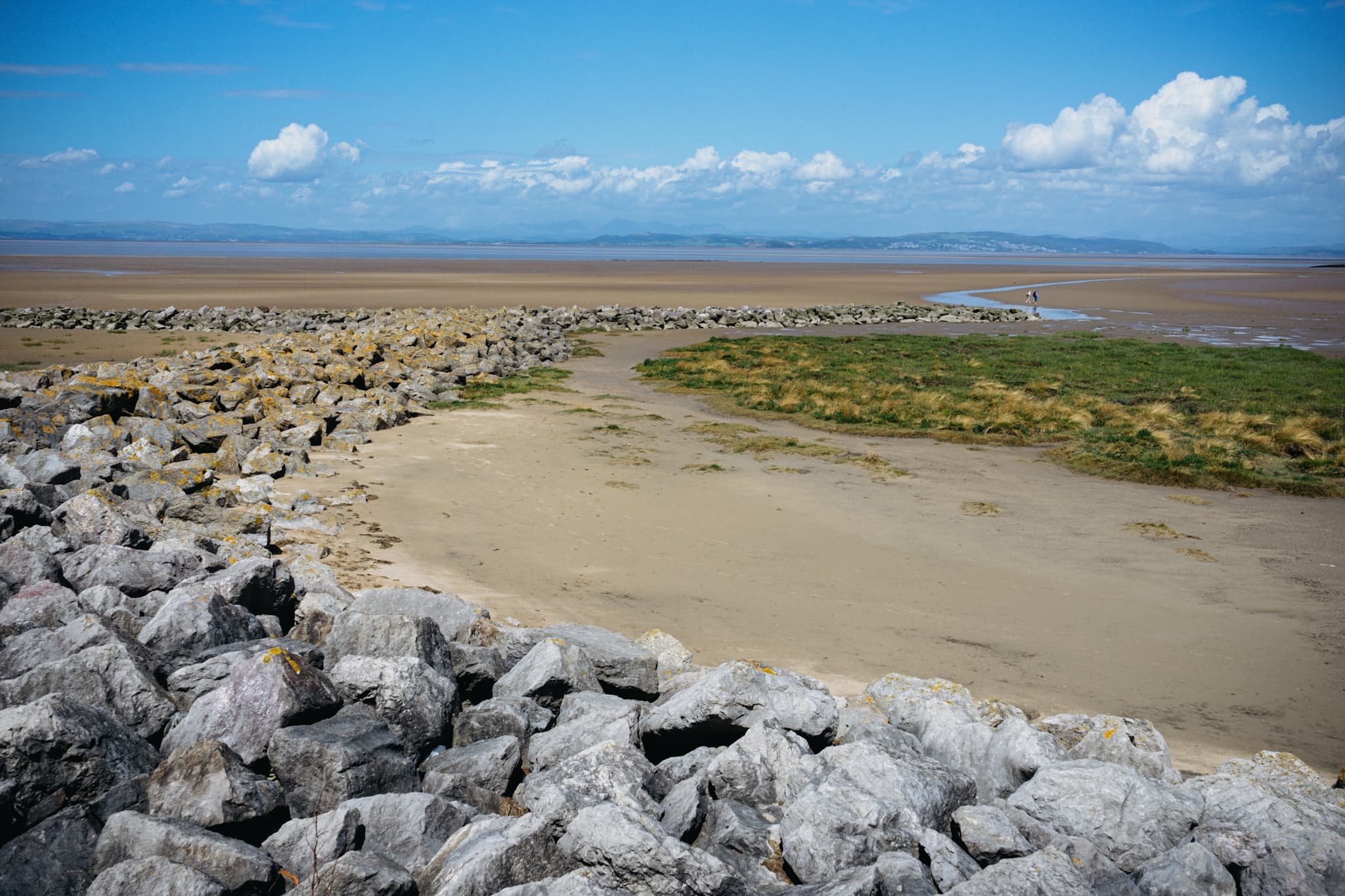
One of numerous breakwaters along Morecambe. This is Grosevenor Breakwater, with Black Combe (600 m/1,970 ft) rising in the distance.
It’s always nice to see people soaking in the vibes of the day and taking in the immense views that Morecambe has to offer.
South beyond the town of Morecambe, ancient Heysham comes into view, resting on a small hill above the Bay.
St. Peter’s church. Christian worship has been regularly practised at the site for over 1,000 years.
The graveyard behind the church enjoys spectacular views across the Bay.
Trees in the graveyard remind us of the passing of time beyond our own horizons.
The ruins of St. Peter’s chapel, dating from around the 8th or 9th century. It gives me vibes of a portal to another world.
A group of six stone-hewn tombs dating from around the 11th century. Each tomb has an associated “socket”, which was probably where a wooden cross would be inserted.
At Half Moon Bay, just before Heysham Nuclear Power Station, one can find the marvellous SHIP sculpture by Anna Gillespie.
The ship's hull is mounted with two opposing figures at each end. One faces "new" Heysham, the Nuclear Power Station, and the other faces "old" Heysham, the ancient monument of St Patrick's Chapel.
The sculpture "celebrates Morecambe Bay's landscape and maritime heritage, and reflects the importance of seaborne trade in bringing news, innovation and shaping the character of the area."
Heading back to Morecambe, I couldn’t resist nabbing the colour contrast of pink and green courtesy of these flowers.
The way back to Morecambe, with plenty of other peeps enjoying the day out in the glorious sunshine.
This gentleman was raising people’s spirits with tunes from his pocket trumpet. He was also kind enough to pose for a photo or two and give us a rendition of “Bring Me Sunshine”, an appropriate tune for the town of Morecambe.
Did you enjoy these photos?
Arnside, Cumbria, Summer
I hope everyone had a lovely Summer Solstice.
I hope everyone had a lovely Summer Solstice.
When it comes to nature and the Summer Solstice, Lisabet and I are fortunate to have a variety of options on our doorstep. With a clear and cloudless evening ahead we decided on the expansive views offered at Arnside.
Arnside is a proper bonny seaside village located on the banks of the Kent Estuary, which eventually spills out into Morecambe Bay. Arnside features a ½ km long viaduct that carries trains across the estuary, and Arnside Tower; a peel tower, built in the 14th/15th century. Another curiosity is the Arnside Bore, a very fast rising tidal bore that occurs most high tides. People often watch the bore from the shoreline, marvelling at the faster-than-walking speed of the tide as Morecambe Bay refills the Kent Estuary every high tide.
For our evening, we just took a gentle meandering stroll along the shoreline of Arnside, enjoying the light and scenes as the sun set on the longest day of the year.
All photos taken on my Sony α7ii using my Sony FE 28–70mm f3.5–5.6 OSS zoom and Rokinon 14mm f2.8 ED AS IF UMC prime lenses. RAWs were developed in Lightroom, processed in Photomatix, and finalised in Photoshop.
Arnside, Cumbria, Summer by Ian Cylkowski is licensed under CC BY-NC-SA 4.0![]()
![]()
![]()
![]()
The gentle curves of the Arnside shoreline catches the golden sunset light, serving as a leading line towards the Arnside Viaduct and the distant Lake District fells beyond.
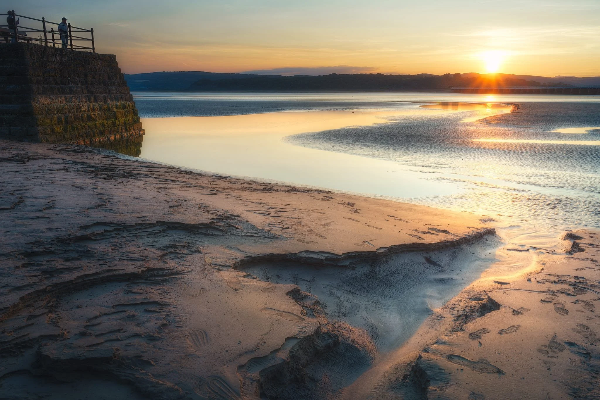
Probably my favourite shot of the evening. A small channel in the sand provides a nice leading line towards the sunset as onlookers from the pier enjoying the solstice.
Beached buoys provide a nice foreground subject as the sun gently sinks behind the fells.
A tighter composition focusing on this tidal channel as it reflects the fiery sunset light.
Back on the road, I equip my ultra-wide for this composition in the dying light of the day.
Did you enjoy these photos?
Ynys Llanddwyn, Anglesey, North Wales, Spring
Newborough beach and Ynys Llanddwyn is a magical place.
Newborough beach and Ynys Llanddwyn is a magical place.
Located at the southern corner of Anglesey island (Ynys Môn), Newborough comprises of 2,000 acres of Corsican pine woodland, planted between 1947 and 1965 to stabilise the shifting sand dunes of Newborough Warren. Emerging from the forest, you enter the expansive sands of Newborough beach with crystal clear views across the Menai Strait to the Snowdonia/Yr Eryri mountains.
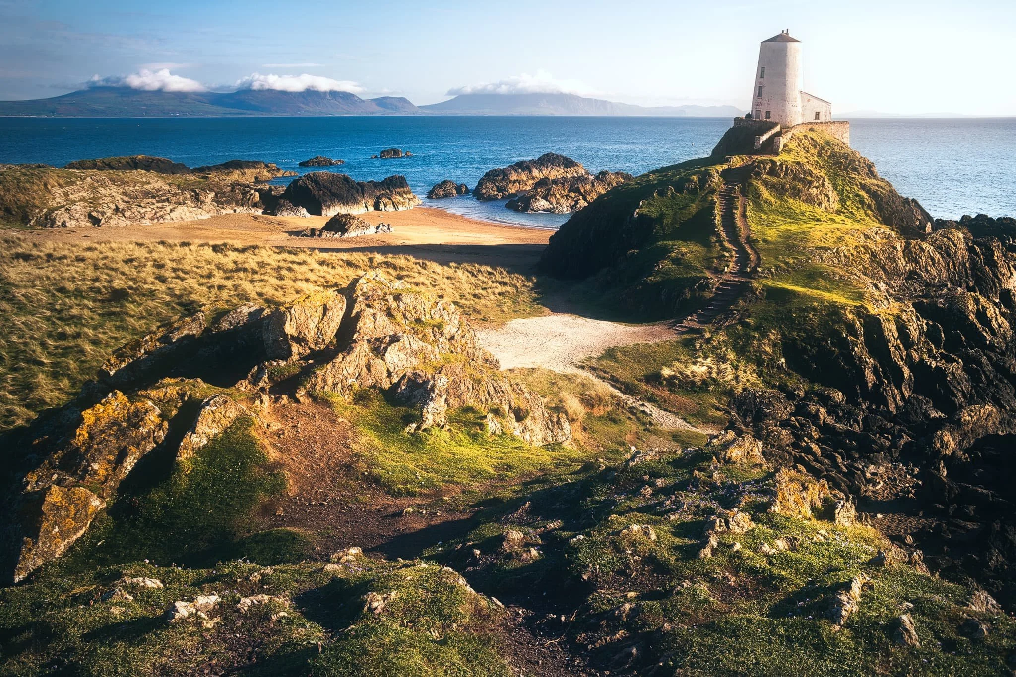
At low tide you can access a small rocky island off the beach, known as Ynys Llanddwyn. The island has historical attachments to St. Dwynwen, the Welsh patron saint of lovers. Ynys Llanddwyn translates to “The island of the church of St. Dwynwen”. It contains the ruins of St Dwynwen’s church, a giant cross on the island’s summit, and the iconic Tŵr Mawr lighthouse.
We couldn’t have picked a more beautiful evening to revisit this ethereal place.
All photos taken on my Sony a7ii using my Vivitar “Series 1” 28–105mm f2.8–3.8 zoom and Rokinon 14mm f2.8 prime lenses. RAWs developed in Lightroom for iPad, edited and finalised in Affinity Photo 2 for iPad.
With the tide out, the already expansive beach at Newborough seemed even bigger. Long channels of pools provided nice compositions involving the mountains of Yr Eryri.
Looking back east along the beach, the sun beautifully lights up the dunes of Newborough Warren, whilst dramatic clouds break up above the mountains of Yr Eryri.
We enjoyed a gentle meander along the beach, slowly but surely heading our way towards Ynys Llanddwyn. Up on the crags, you can see where the tide would separate the island from the beach.
Ynys Llanddwyn is chock-full of rare flora, so it’s generally advised to keep to the dedicated paths, which I made a composition of. In the distance you can just make out the island’s cross and Tŵr Mawr lighthouse.
There are two crosses on Ynys Llanddwyn, this is the Celtic one. Strong side light elevates the scene and highlights some of the Yr Eryri mountains that are crowned with clouds.
A magical moment. Evening golden side light drenches the island and its lighthouse, Tŵr Mawr. In the distance, the Yr Eryri mountains are capped with their own little clouds. A moment I’ll never forget.
Near the smaller tower on the southeastern tip of Ynys Llanddwyn, some volcanic rock formations provide a lovely composition against the endless waters of Caernarfon Bay.
Did you enjoy these photos?

Hodbarrow Nature Reserve, Cumbria, Autumn
Time for somewhere a little different.
Time for somewhere a little different.
For a little while now we’ve had our peripheral vision on a little-known nature reserve in southwest Cumbria: Hodbarrow Nature Reserve.
Today was the day to visit and explore it.
The nature reserve occupies the site of a former iron ore mine, which was in operation until the 1960s. The RSPB purchased the nature reserve in 1986, and are managing the area to sustain numbers of terns, wintering red-breasted mergansers, as well as wintering teals, coots, little grebes, redshanks and dunlins, and breeding great crested grebes. They are also looking to re-establish the nationally rare natterjack toad.
While parts of eastern Cumbria and North Yorkshire were looking cloudy and rainy, the southwest Cumbrian coast at Millom was thankfully sunny and clear, with gorgeous painterly high-altitude clouds aiding our photos.
Photos taken on my Fujifilm X-T2 using my Vivitar “Series 1” 28–105mm f2.8–3.8 zoom and Laowa 9mm f2.8 prime lenses. Images are 90% made in-camera using Shark & Palm’s “Kodak Ektar 100” film recipe. Finalised using Affinity Photo 2 for iPad.
Hodbarrow Nature Reserve, Cumbria, Autumn by Ian Cylkowski is licensed under CC BY-NC-SA 4.0![]()
![]()
![]()
![]()
What became immediately obvious to me and Lisabet upon our arrival was how quiet the nature reserve was. Absolutely delightful.
Beautiful “brush stroke” clouds decorated the skies above the flooded “lagoon” of the nature reserve.
The fell that commands your attention all around the nature reserve is Black Combe, an isolated Lake District fell of 600m high.
However, further into the distance are the Coniston fells, looking sublime as the clouds cast painterly shadows across the slopes of the fells.
An old abandoned lighthouse, possibly abandoned in favour of the newer one further southeast of the nature reserve. The little stub of a building in the distance to the right is the ruins of a windmill. The old windmill was used by Hodbarrow Iron Ore Mine to store gunpowder, used for blasting, between 1855 and 1880, when a purpose-built facility was built.
A clearer panorama of the Coniston fells.
A crackin’ composition I couldn’t resist. The old lighthouse reflected in the lagoon with the hump of Black Combe in the distance.
The crags of Hodbarrow Point, subject to constant erosion by the tides of the Duddon Estuary, itself connected to Morecambe Bay.
Beautiful strokes of painterly clouds adorn the skies above Black Combe. Attached to the nature reserve’s lagoon is the Hodbarrow Marina.
An old couple enjoy the views across the Duddon Estuary as feathery clouds streak across the sky.
As we approached the newer lighthouse, I noticed lots of large puddles nearby the enticed me to try my hand at a reflection composition. Not bad.
The “lagoon” of the nature reserve is protected from the sea by this beautiful sea wall, built in 1905.
Faded grandeur. Plus the streaky clouds enabled an ultra-wide composition as they “pointed” towards the lighthouse.
From the top of the sea wall, the ever-stretching expanse of Haverigg beach comes into view.
Looking along the sea wall all the way back to the Furness peninsula.
A simple scene, but beautiful nonetheless.
I enjoy the way the curve of the lagoon is mirrored in the curves of the clouds above.
After lunch, we re-emerged into the nature reserve with considerably more cloud cover. The Lakeland fells, however, were still looking magnificent.
The clouds grew larger and tighter around the sun. That would be it for the day.
Did you enjoy these photos?

Port Eynon, Gower, South Wales, Autumn
Just outside of the Pembrokeshire Coast National Park, one can find other excellent stretches of South Wales coastline.
Just outside of the Pembrokeshire Coast National Park, one can find other excellent stretches of South Wales coastline.
East of Pembrokeshire, Swansea is home to the Gower Peninsula and the Gower AONB (Area of Outstanding Natural Beauty). We had already explored a small section of this area at the start of our holiday at Mumbles. But further along the coastline from Mumbles one can find a stretch of fantastical coastline between Port Eynon and Rhossili.
Whereas the cliffs at Lydstep Head were more vertiginous, at the Gower Peninsula the cliffs are formed from a faulted and folded sequence of Carboniferous rocks. More recent sculpting occurred in the last Ice Age as the Gower lay on the southern margin of the last ice sheet. As a result, the cliffs here feature fantastic shapes of curves and folds smashing into each other at peculiar angles.
All photos taken on my Fujifilm X-T2 using my Vivitar “Series 1” 28–105mm f2.8–3.8 zoom and Laowa 9mm f2.8 prime lenses. RAWs converted in Capture One for iPad, developed and finalised in Affinity Photo for iPad.
Port Eynon, Gower, South Wales, Autumn by Ian Cylkowski is licensed under CC BY-NC-SA 4.0![]()
![]()
![]()
![]()
Port Eynon Bay, with its long sandy beach and tall dunes. Port Eynon is thought to be named after Prince Einion of Deheubarth or an 11th-century Welsh Prince named Eynon. “Eynon” is apparently a fairly common surname in Wales.
West of the beach one can hike up the cliffs to summit Port Eynon Point. My lovely Lisabet pictured here heading straight for the knife-edge tip of Port Eynon Point.
Looking back along the limestone cliff edge from Port Eynon Point towards the summit trig point, the open Overton Mere, and the Gower cliffs beyond.
From Overton Mere, looking back at Port Eynon Point, it’s easier to see the folding of limestone that’s occurred around this stretch of the Gower Coast. Seemingly impossible shapes and lines that are entirely natural.
Below Overton cliff more fantastic shapes are revealed, millions of years of folding, faulting, erosion, and glacial scouring.
On top of Long Hole cliff we navigated a join in the folds of limestone to use as a leading line towards the Common Cliffs, as beautiful late afternoon light highlights their shapes.
Did you enjoy these photos?

Tenby & Lydstep Head, Pembrokeshire, South Wales, Autumn
After a morning spent carefully watching the weather apps, it was time to venture out.
After a morning spent carefully watching the weather apps, it was time to venture out.
Southwest of Wales one can find the historical port town of Tenby, or Dinbych-y-pysgod (“Fortlet of the fish”) to give its proper Welsh name. While we drove through the lashing rain, we arrived at Tenby in relatively dry conditions, wandering around the town and its beaches as the clouds gradually lifted and broke apart.
With the light getting better and better, we drove a further ten minutes southwest to Lydstep Head, a new location for us, to check out the area’s fabled cliffs.
Boy it did not disappoint.
Photos taken on my Fujifilm X-T2 using my Vivitar “Series 1” 28–105mm f2.8–3.8 zoom and Laowa 9mm f2.8 prime lenses. RAWs converted in Capture One for iPad then developed and finalised in Affinity Photo for iPad.
Tenby & Lydstep Head, Pembrokeshire, South Wales, Autumn by Ian Cylkowski is licensed under CC BY-NC-SA 4.0![]()
![]()
![]()
![]()
Tenby
St. Catherine’s Island is a tidal island, just off Tenby’s south beach. It’s home to St. Catherine’s Fort, a Palmerston Fort constructed in the 19th century, in response to concerns about an imminent invasion from Emperor Napoleon III of France. Since the 1960s the Fort has stood empty, owned by no-one, though there are community initiatives to accommodate visits and tours.
This is the old Lifeboat Station, built in 1905 and superseded by the newer one just round the corner of Castle Hill in 2008. The old Lifeboat Station is now a private residence. Can you imagine?
As we continued to round the shoulder of Castle Hill the clouds above broke up and lifted. This allowed glorious autumnal sunlight to start emerging onto the scene, highlighting the beautiful coloured buildings of Tenby.
Tenby Harbour, enjoying a lot more sun as the clouds were lifting and breaking. Such a wonderful Welsh coastal scene.
Gosker Rock, which stands conspicuously all on its own on Tenby’s north beach.
Back on Tenby’s south beach, conditions were really starting to get epic. Time to head back to the car and find the cliffs of Lydstep Head.
Lydstep Head
On Lydstep Head, passing squalls quickly dowsed us in rain before carrying on across the sea. Their cloud formations made for epic compositions. I stacked 5 frames on top of each to shoot this photo of the cliffs at Lydstep Point with the rain clouds being lit up in the distance.
East from Lydstep Head another squall dropped a load of rain on top of Caldey Island. I zoomed in for a tighter composition of this fantastic phenomenon.
I mean, wow. The vertical cliff pictured here is Whitesheet Rock, with its dramatic vertical folds. Lots of Pembrokeshire’s coastline is comprised of limestone, which can often produce incredulous rock and karst formations.
A tighter composition of Whitesheet Rock. It doesn’t seem possible that cliff formations can look like this.
The other side of Whitesheet Rock above the aquamarine waters of Lydstep Haven.
Getting some of these compositions around Lydstep Head’s cliffs were some of the most challenging tasks I’ve ever done. The winds coming across the sea were funnelled through and around the geography of the area, creating blusters of 50+ mph. For a lot of these photos, I pretty much had to “spray and pray” to ensure I got something.
Powerful winds force the sea to crash against and around the cliffs of Lydstep Head, as they have surely done for millennia. Who knows what these magnificent cliffs will look like in another thousand years?
Much of Lydstep Head is owned and maintained by the National Trust. Period regenerative grazing occurs here, but closer to the cliffs the land is largely left to do what it will in the elements.
A slow-moving squall sits above Caldey Island in the distance whilst the sun drench the Lydstep cliffs with warm late-afternoon light as powerful winds blast the sea at the seemingly impossible cliffs.
Beyond Lydstep Head to the west, the Pembrokeshire Coastal Path continues over and above the cliffs. That will have to wait for another day.
For this day, circumnavigating Lydstep Head in glorious light and epic conditions was more than enough for the day.