
Oxenber & Wharfe Woods, Yorkshire Dales, Spring
It’s been nearly a month since my last post.
It’s been nearly a month since my last post.
I must apologise for that. Times, they are a’ changin’.
To start, we moved house! That in itself has consumed most of my time and energy, as house moves usually do. Thankfully we’re now all settled in and getting down to the important things in life, like looking at curtain textiles and measuring all the things.
With things settling back down a little, and the British weather drastically improving, we thought we’d try to capture the last of this year’s bluebells. Over the years we’ve found some proper lovely places to photograph bluebells, such as:
This time we tried somewhere new, to us, based on personal recommendation: the woods of Oxenber and Wharfe near Feizor.
And we were absolutely blown away.
Carpets of bluebells, some in ancient woodland, some out in the open with spectacular views to the likes of Moughton Scar and Ingleborough.
Happily, this was also my first full outing with my newly acquired Sony 24-240mm F3.5-6.3 OSS, courtesy of my Dad. This lens easily replaced five other lenses I had, which has significantly reduced my carrying load.
I hope you enjoy these photos as much as I enjoyed taking and editing them.
All photos shot on my Sony α7ii using my Sony 24-240mm F3.5-6.3 OSS zoom lens. RAWS edited in Lightroom, edited in RNI Films, and finalised in Photoshop.
Oxenber & Wharfe Woods, Yorkshire Dales, Spring by Ian Cylkowski is licensed under CC BY-NC-SA 4.0![]()
![]()
![]()
![]()

Our hike started from Austwick and we were soon on the easy well-defined trail towards the elevated Oxenber and Wharfe woods.
A beautiful Holstein Friesian lady, basking in the glorious sunshine.
We followed Wood Lane as the trail started to ascend. Looking back across the segmented fields towards Robin Proctor’s Scar and the Norber Erratics.
The signage was clear enough as to where we needed to go.
Soon enough we began the short and sharp ascent off Wood Lane and into Oxenber Wood. Bluebells everywhere.
This area of woodland and pasture was once an important quarry and source of timber for Austwick. Now it’s marked as an SSSI and largely left to its own devices.
Open areas of former pasture meant acres of bluebells, out in the open, enjoying views towards the likes of Moughton Scar and Ingleborough.
A carpet of bluebells with Moughton Scar on the left and Bargh Hill on the right.
Higher up, more former pasture land has given way to more bluebells. I found this solitary limestone boulder covered in moss that made for a lovely composition.
In addition to all the bluebells were tracts of limestone pavement, much to my delight!
Entering the denser woodland of Wharfe wood, a small trail branched off, giving views towards Moughton Scar.
Wharfe wood’s thicker coverage meant for beautiful soft light and trees covered in moss and lichen.
A small trail heads deeper into Wharfe Wood, with a hint of yet more bluebells beyond. Our route was to exit out of the eastern end of the woodland, but not before I chanced upon this mystical scene.
Popping out of Wharfe Wood, the unmistakable shape of Pen-y-ghent quickly makes itself known to us.
The route now followed the Pennine Bridleway towards Feizor. To the left are the shoulders of the limestone hills above Feizor.
This year’s spring lambs, of the Swaledale kind, quickly scampered to their mums.
On our descent to Feizor I spotted this little cottage and its field covered in buttercups.
The rest of the route back to Austwick was simple enough, just follow the Pennine Bridleway from Feizor to Austwick. This ancient country lane was lined with wild garlic (Allium ursinum) and its delicious smell.
The collapsed ruins of Meldings Barn, with a doorway still standing on its own.
Back at Austwick, the local cows gently made their way to Austwick Beck for a cool down and a drink to relieve from the warm spring day.
Did you enjoy these photos?

The Roaches & Lud’s Church, Peak District, Autumn
We’re in the Peak District in the fortnight!
We’re in the Peak District for a fortnight!
The last time we explored the Peak District was way back in May 2015. Even then, it was only for a long weekend.
After a gentle Saturday spent enjoying the sights and sounds of Buxton, we embarked on a more strenuous Sunday; a 10km hike along the Roaches to the summit, then down into Back Forest to explore the chasm of Lud’s Church.
20,000+ steps, 1,184 ft of ascent and 1,178 ft of descent. My feet are paying the price.
Totally worth it though.
All photos shot on my Sony α7ii using my Sony FE 28–70mm f3.5–5.6 OSS zoom and Rokinon 14mm f2.8 ED AS IF UMC prime lenses. RAWs developed in Capture One for iPad, finalised in Lightroom for iPad.
The Roaches & Lud's Church, Peak District, Autumn by Ian Cylkowski is licensed under CC BY-NC-SA 4.0![]()
![]()
![]()
![]()
The steepest and most sheer of the Roaches’ crags are at the southeastern end. In the distance, the pyramidal shape of Hen Cloud (410 m/1,315 ft) can be seen, an outlier of the Roaches separated by a col.
The Roaches are especially popular at the weekends. It’s easy to see why. Apart from hikers and freerunners, these crags attract climbers and boulderers seeking challenging projects to tackle.
To get on the trail above the Roaches, we followed the smaller trail below them and through this beautiful autumnal woodland, once the site of an old quarry.
It’s a long way down. Although the day was hazy, and unreasonably warm for an October day (20ºC), the views from the Roaches are extensive.
Looking northeast towards the Five Clouds, with a sheer drop down to the valley in front of me. Beautiful autumnal colours are just starting to emerge.
The name of this area, the Roaches, comes from the French les roches, meaning “the rocks”. These crags are made of a coarse sandstone called gritstone, deposited millions of years ago as part of an ancient river delta. Over time the surrounding landscape eroded away, leaving these isolated crags standing tall.
From the summit, 505 m above sea level, the 360º views are extensive. Beyond these crags you can make out the smaller ridge above Back Forest.
Passing through the crags on our way down to Back Forest, I spot a young couple staging a precarious “cliffhanger” for a photo.
These two windswept crags provided a wonderful frame of the distant hill towards Congleton.
The last of these overhanging crags must provide a wonderful challenge for boulders and climbers.
Our route involves a sharp drop down to the col. At this point, we’d follow the trail down to Back Forest. Our next destination was the epic Lud’s Church.
We gingerly navigated the extremely muddy path through Back Forest until, eventually, we found the way down to the chasm of Lud’s Church. Before getting down to the bottom, a small slot to the side catches my eye for a photo.
And here, we’re down to the bottom of Lud’s Church. This is a 60ft chasm in the woods of Back Forest, caused by a huge landslip in the Gritstone bedrock. Even on a warm October day, Lud’s Church is wet, dark, and refreshingly cool. It is also rather muddy.
You may be wandering about the name. This chasm has Christian history. A group of Christian reformers, the Lollards, apparently used this place to worship in the early 15th century. It may have been named after a Walter de Ludank/Walter de Lud-Auk, who was captured here at one of the aforementioned “services”.
Did you enjoy these photos?

Llandovery & Cwm Rhaeadr, South Wales, Autumn
If there’s a feature that—to my mind—typifies South Wales that isn’t it’s glorious coastline, it’s the waterfalls.
If there’s a feature that—to my mind—typifies South Wales that isn’t it’s glorious coastline, it’s the waterfalls.
In fact, in the heart of the Brecon Beacons National Park lies an area called Waterfall Country.
Outside of Waterfall Country though there are still plenty of places to find waterfalls. One of the bigger ones can be found in Cwm Rhaeadr Forest, north of the historical town of Llandovery.
After a morning spent wandering around this beautiful little town, we head to Cwm Rhaeadr forest to enjoy some forest bathing, autumnal colours, and one of the largest and most epic waterfalls we’ve ever come across.
All photos taken on my Fujifilm X-T2 using my Vivitar “Series 1” 28–105mm f2.8–3.8 zoom and Laowa 9mm f2.8 prime lenses. RAW files converted in Capture One for iPad, developed and finalised in Affinity Photo for iPad.
Llandovery & Cwm Rhaeadr, South Wales, Autumn by Ian Cylkowski is licensed under CC BY-NC-SA 4.0![]()
![]()
![]()
![]()
Llandovery
On the southern side of Llandovery is a small knoll that overlooks the town, atop of which is perched Llandovery Castle. Next to the castle ruins is a stainless statue of Llywelyn ap Gruffydd Fychan, a wealthy Carmarthenshire landowner who was executed in Llandovery by Henry IV of England in punishment for his support of Owain Glyndŵr's Welsh rebellion.
The Normans built a castle here around 1166 AD, and it was rebuilt in stone in the 13th century. It was burnt down in the 16th century and never rebuilt. From the ruins you can enjoy vast views of the nearby hills of South Wales plus Llandovery’s car park. Lovely.
Towns in South Wales seem fond of their colourful buildings, and the Bear Inn in Llandovery is definitely one of the more vivid ones I’ve seen.
This is the 4th incarnation of Llandovery Town Hall, built in 1858 in the Italianate style. The first town hall on the site was built in 1485.
Cwm Rhaeadr Forest
In Cwm Rhaeadr Forest, glorious autumnal colours carpet the forest floor.
Our first glimpse of the massive waterfall as it roars down from Mynydd Mallaen 1,500ft above. Time to get as close and personal with the waterfall as we can.
She’s a powerful beauty! It was damned hard trying to get close to the waterfall, but many slips and slides we made it. I quickly equipped my 9mm ultra-wide lens to snap as many compositions of this waterfall’s sections as I could.
Cwm Rhaeadr waterfall drops about 100m+ from Mynydd Mallaen in between two crags, falling in several stages as various falls and cascades. That means it’s possible to scale down alongside the waterfall and shoot completely different compositions from each particular drop.
I shot many different compositions of this waterfall as we scaled down alongside it. Some were definitely shit, as getting a solid enough footing proved difficult. The ones you see above were the best I could manage.
Did you like these photos?
The Castles of Lllandeilo, South Wales, Autumn
We’re in South Wales for a fortnight!
We’re in South Wales for a fortnight!
It feels great to relax and have a proper break from the severely challenging year we’ve had.
Arriving at our holiday property Friday evening—after a gruelling 5-hour drive in the lashing rain—we woke up Saturday deciding to explore the area nearby where we’re staying around Llandeilo.
Llandeilo is a small town on the western edge of the Brecon Beacons National Park. It’s proper bonny. Evidence of Roman occupation from around 74AD has been discovered here; later on, the settlement was named after a famous Celtic monk—Saint Teilo—with the Welsh word llan meaning a church or monastery, hence the name Llandeilo (pronounced Shan-DAY-loh).
Owing to the long and rich Christian and royal history in the area, there are lots of castles nearby. We explored just two of them: Dinefwr and Castell Carreg Cennen, both impressive in their own right.
After Friday’s insane amount of rain, conditions on the Saturday were thankfully dry and epic.
All photos shot on my Fujifilm X-T2 using my Vivitar “Series 1” 28–105mm f2.8–3.8 zoom and Laowa 9mm f2.8 prime lenses. RAWs converted using Capture One for iPad, developed and finished in Affinity Photo for iPad.
The Castles of Llandeilo, South Wales, Autumn by Ian Cylkowski is licensed under CC BY-NC-SA 4.0![]()
![]()
![]()
![]()
Dinefwr Castle
Below the Dinefwr estate woods, beautiful autumn light and foliage wraps this gorgeous house.
Inside the keep of Dinefwr Castle (pronounced din-EH-vor). The advantage of a 9mm ultra-wide lens is that you’re able to capture a massive field of view in tight compositional situations like this.
Despite being largely built in the 13th century, a lot of the castle is still standing tall and strong.
It’s easy to see why a castle was built here. It’s position on a hill allows for extensive views over the Twyi valley.
It’s possible to climb up the battlements for even more extensive and panoramic views. Autumn colours are just starting to appear in South Wales at the moment.
Up on the highest point of the ruins, looking over the battlements and keep across the Twyi valley on a cloudy and windy day. Truly moody.
The winding stairway leading up is narrow and challenging, especially as the steps themselves are smooth and insubstantial. Amazing how much smaller people were back then.
There’s been a castle at this site since the mid-12th century, but most of present ruins can be attributed to the work of Rhys Gryg in the early 13th century. The castle came into English hands by the end of the 13th century courtesy of King Edward I of England.
By the end of the 15th century the castle came into the hands of Sir Rhys ap Thomas, who began the process of rebuilding and improving the castle. Sir Rhys was a favourite of King Henry VII, largely due to Rhys’ crucial involvement in the Wars of the Roses.
In the distance to the right you can see the turrets of Newton House, built in the 17th century with massive renovations in the 19th century. Around the time of Newton House’s construction, Dinefwr Castle was modified to serve as a summer house.
The castle and its environment were relatively quiet, with most people opting to check out Newton House instead, further to the north. As such, Lisabet and I had ample opportunity to properly explore and photograph the site.
Within the Dinefwr Estate woodland, I spied some gnarly trees covered in moss and quickly sought to make a composition of this gorgeous scene.
The sun appeared from the clouds once again, bathing this house in the woods in autumnal light.
Newton House and its turrets, a wonderful autumnal and historic scene.
Castell Carreg Cennen
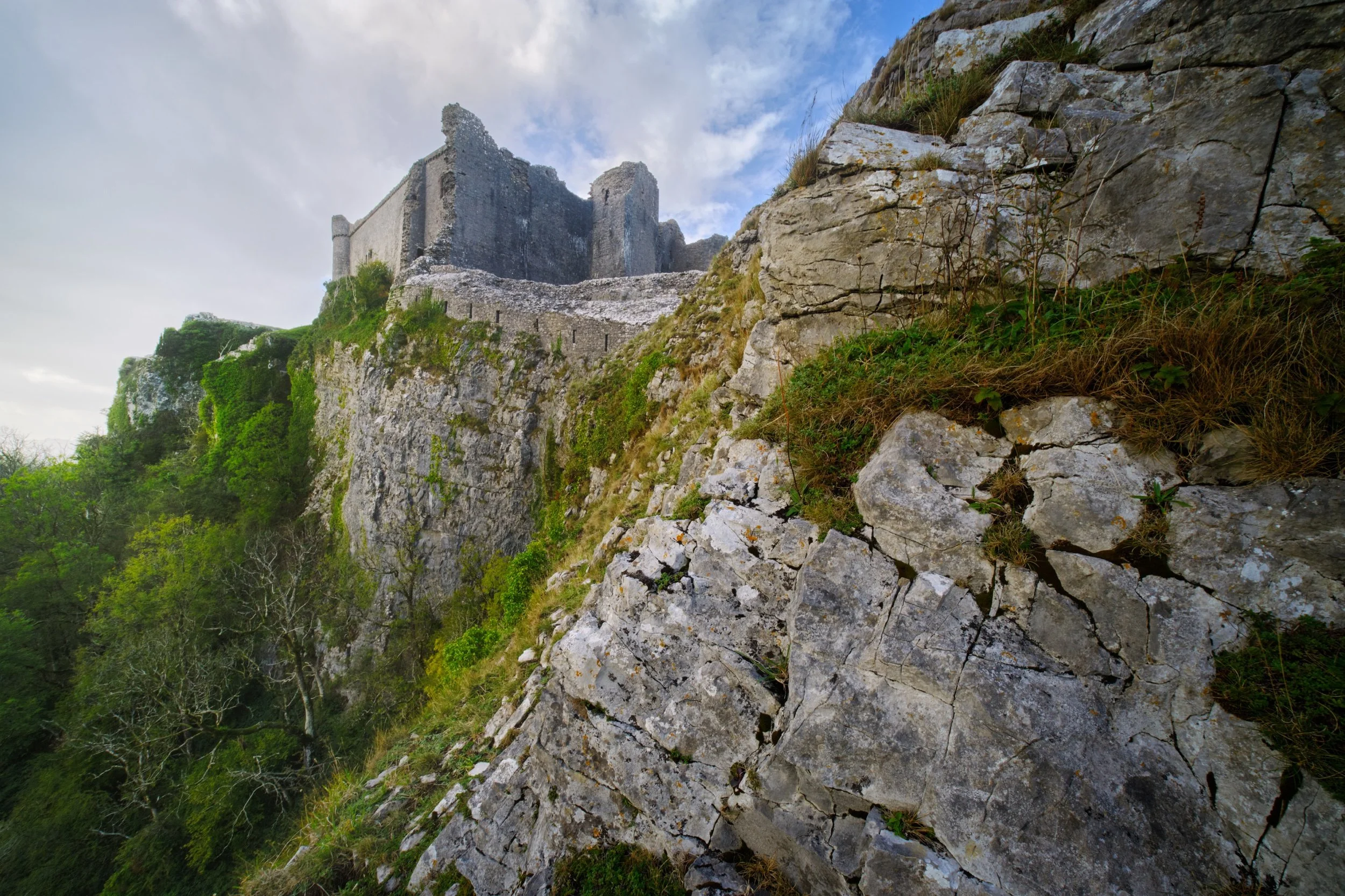
For our second trip for the day, we drove south east of Llandeilo into the Brecon Beacons National Park. Here one can find the impressive ruins of Castle Carreg Cennen, perched atop a high and might limestone crag above the River Cennen.
Rather then head straight into the ruins, Lisabet and I opted to scout around the shoulders of the crag. That’s how we found this ridiculous scene, with the castle perched on the limestone crag and a sheer 300ft drop down.
During our afternoon visit here the weather was much more inconsistent, alternating between brilliant bursts of light and sudden downpours. Whilst I was negotiating my way through the ruins, the sun once again burst through the racing clouds, illuminating this scene.
Castell Carreg Cennen was built in the 12th century, much like Dinefwr Castle, and similarly was claimed by the English through the conquest of King Edward I of England. These days the castle and its land is privately owned by the farm underneath it.
Frankly, one of the most stupendous and visually arresting castles I’ve ever seen.
Back at the farm beneath the castle ruins, a small herd of English Longhorn cows came to graze. Incredible creatures.
A beautiful shaggy coat with those imposing curling horns.
Did you enjoy these photos?
Barkbooth Lot, Lake District, Spring
Welcome back to Barkbooth Lot!
Welcome back to Barkbooth Lot!
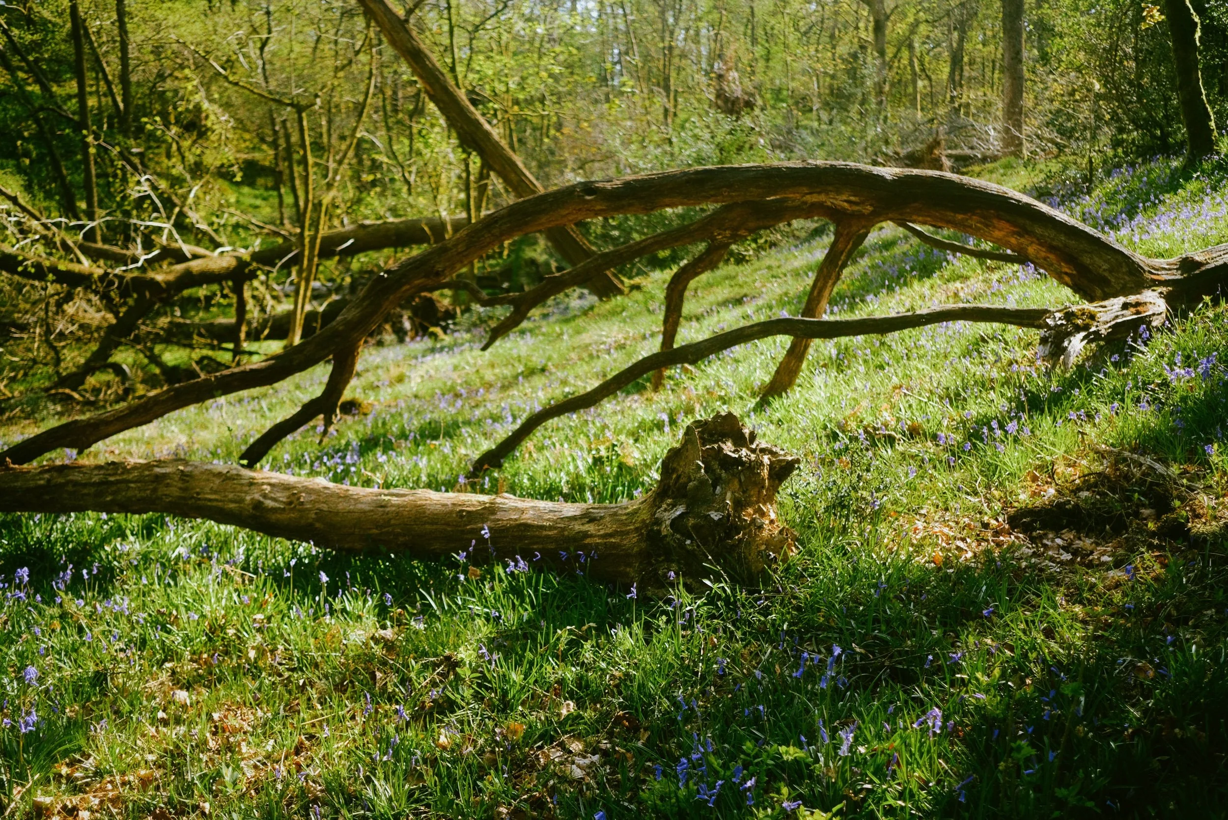
We're starting to see those beautiful bluebells appearing in woodlands across Cumbria now, so over the weekend we enjoyed a wander around our new favourite bluebell spot, Barkbooth Lot.
There's another good three weeks or so before all the bluebells are fully out and in their prime, but the sights were still glorious. Plus, it were a bonny day. Why not get out and enjoy it?
All photos shot on my Fujifilm X-T2 using two of my prime lenses: a Fujinon 23mm f/2.0, and an adapted Pentax SMC 55mm f/2.0. Images developed using RNI Films' Portra 400 film emulation.
The way into the woodland is clear and immediately we can see that the bluebells were out.
The late afternoon light was absolutely crackin'.
A survivor from Storm Arwen. Lots of other trees weren't so lucky.
Fantastic shapes, like two dancers in the sunlight.
Two trees share a trail of bluebells between them.
There's so many more bluebells to come in the next couple of weeks.
This way for more bluebells.
Ferns unfurling. A sign that summer is coming.
Some of the casualties from Storm Arwen.
Down at the gentle beck, gurgling its way through the woodland.
Forest bathing is a true healing salve for the soul.
A remnant from an older storm.
Probably one of my favourite shots from the whole walk.
Torn in half. The sheer force of Storm Arwen.
Out onto the fell side of Barkbooth Lot, the Lyth Valley fells in the distance.
Ennerdale, Lake District, Winter
Compared to Buttermere’s clear blue skies, Ennerdale could not have been more different.
Compared to Buttermere’s clear blue skies, Ennerdale could not have been more different.
I think the last time we were at Ennerdale was in April 2017. Goodness. That’s coming on to 5 years now. It’s one of my favourite places in the Lake District, with a distinctly unique “vibe” compared to any other area in the National Park.
Ennerdale is a long valley by Lake District standards, measuring around 10-miles long. There are no settlements here, save for the Low Gillerthwaite Field Centre, Ennerdale YHA, and Black Sail Hut right at the head. Ennerdale Water sits at the foot of the dale, offering views all the way down the valley towards some of the Lake District’s biggest peaks: Great Gable, Steeple, and (one of my favourites) Pillar.
In 2003 the major landowners of the valley—United Utilities, the National Trust, and the Forestry Commission—joined forces to create the Rewilding Ennerdale partnership and project. The project’s stated goal is:
“[…]to allow the evolution of Ennerdale as a wild valley for the benefit of people, relying more on natural processes to shape its landscape and ecology.”
Ennerdale does have a massively different feel compared to the rest of the Lake District. It feels more Scottish in a way.
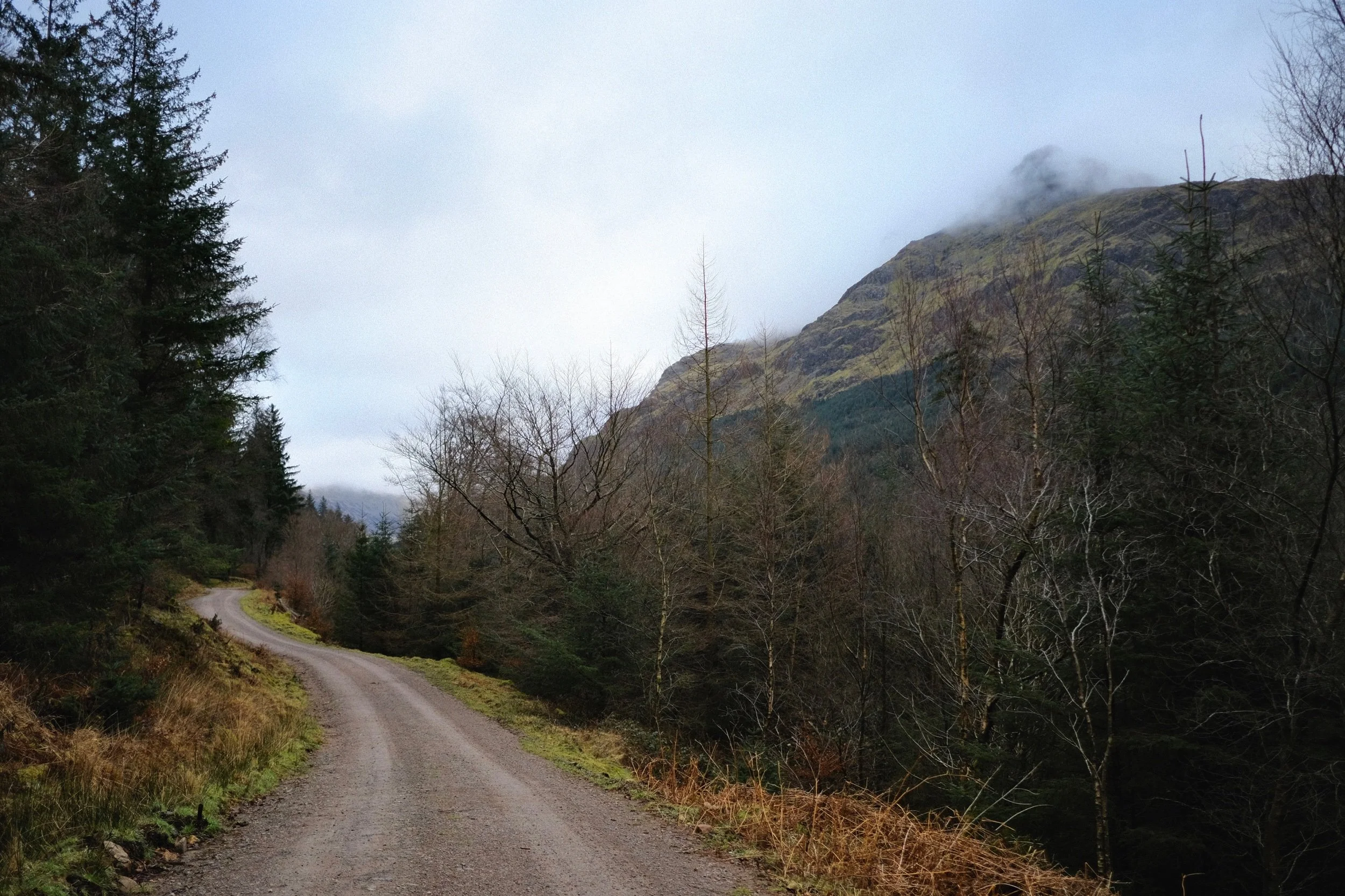
Although on this hike we didn’t see much of the sun, the low clouds did interact with the high fells beautifully, creating gallons of drama for us to photograph.
All photos shot on my Fujifilm X-T2 using my three prime lenses: a Fujinon 23mm f/2.0, a Laowa 9mm f/2.8, and an adapted Pentax SMC 55mm f/2.0. Images made 95% in-camera using Øyvind Nordhagen’s “Modern Negative” Fujifilm recipe.
Following the road from the car park, the views open up and reveal the huge Ennerdale fells tussling with the clouds above.
Across Ennerdale Water, Crag Fell slopes down to an abrupt toe known as Angler Crag, before plunging into the deep lake.
This was the most sun we saw all day. Worth it though. Caw Fell, Haycock, and Scoat Fell fight with the clouds.
A closer view of Angler Crag. It is technically possible to complete a circular hike around Ennerdale Water, but the difficulty is in navigating around this awkward crag.
The cloud cover starts to lift a little bit, with Steeple’s shadow suggesting an appearance.
Lots of trees near the lake shore are covered in thick carpets of moss. Beautifully eldritch.
Beautiful light highlights the reaching arms of this moss-covered tree.
Near the Low Gillerthwaite Field Centre, the forest cover recedes a little and we get out first glimpse of the mighty Pillar. My excitement levels build.
We followed the winding forest track towards Middle Bridge, which cross the River Liza. This would signal our way back down the other side of the valley. Pillar gets closer…
Swirling clouds wrestle with the summit of Pillar.
Like a lot of the Lake District, Storm Arwen took casualties in Ennerdale too.
These trees managed to survive…
…but these two giants didn’t, completely uprooted and tossed aside by the powerful winds of Storm Arwen. Incredible.
Middle Bridge offers beautiful views looking all the way down the rest of Ennerdale.
The River Liza tumbles down the valley here in a series of cascades and falls, each with its own sublime turquoise and azure plunge pools. The water clarity was astonishing.
We crossed the Liza via Middle Bridge, and took the official Liza Trail back towards the foot of Ennerdale. But not without another look back at the crystal clear river and its falls.
Navigating the Liza Trail alongside the river back to the Forest path was tricky, given that several chunks of it had been washed away by Storm Arwen. But views like this from the forest trail made up for it.
Ancient sheep enclosures have long been left to be reclaimed by nature.
Ennerdale Forest, growing taller everywhere.