Haddon Hall, Derbyshire, Autumn
Towards the end of Peak District foray, we decided it was time for something more historical.
Towards the end of Peak District foray, we decided it was time for something more historical.
Lisabet had zeroed in on a grand building near Bakewell known as Haddon Hall. It has been described as “the most complete and most interesting house of its period”. The origins of the hall are from the 11th century, with additions at various stages between the 13th and the 17th centuries, latterly in the Tudor style. Due to the building becoming uninhabited for two centuries until the 1900s, a lot of its tudor and medieval heritage has survived the modernisation of the Georgian and Victorian periods.
It’s been used extensively as a location for filming, including in Treasure Houses of Britain; The Princess Bride; the BBC's adaptation of The Silver Chair; Jane Eyre; Elizabeth; Pride & Prejudice; A Tudor Feast at Christmas; Time Crashers, and Gunpowder.
It’s definitely not a cheap place to visit, but the grounds and hall are absolutely fascinating and incredibly well preserved. I had a lot of fun with my 14mm ultra-wide lens.
All photos taken on my Sony α7ii using my Rokinon 14mm f2.8 ED AS IF UMC ultra-wide prime lens. RAWs developed in Lightroom using Cobalt Image’s Fuji Classic Neg profile.
Haddon Hall, Derbyshire, Autumn by Ian Cylkowski is licensed under CC BY-NC-SA 4.0![]()
![]()
![]()
![]()
The entrance to Haddon Hall’s Lower Courtyard. The main entrance to the Banqueting Hall, built in the 1300s, can be seen to the left.
The way in to the Banqueting Hall, where tour guides are ready to present the story and history of Haddon Hall to visitors (including us).
The main kitchen, west of the Banqueting Hall. It dates from around 1370 CE. The multiple fireplaces would’ve baked bread and spit roasted meats.
The pantry, located in between the kitchen and Banqueting Hall, also built in the 14th century. You can imagine carcasses being hung up on tenter hooks, another being butchered on the wooden slab, whilst butter was being churned elsewhere.
The Buttery, also built in the 14th century. Stone floor and walls would’ve kept the room cool enough to all manner of dairy products to be made and stored here.
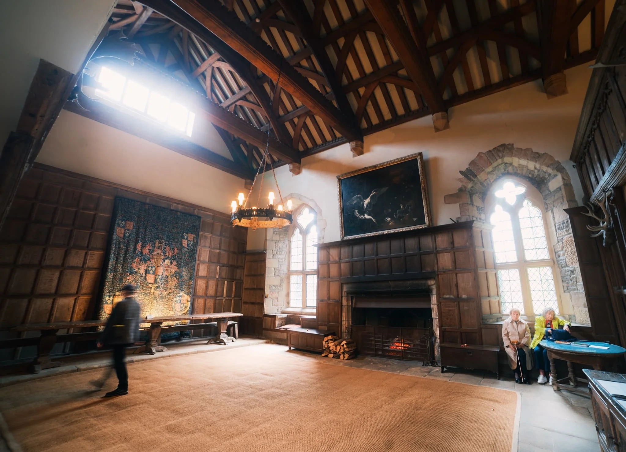
The Banqueting Hall, built in 1370 CE, so it is truly medieval. It remains furnished with its original Dais table, behind which hangs a tapestry gifted to the family by a visiting Henry VIII.
The Great Chamber was a Solar or Solarium, otherwise known as "an upper chamber of a mediaeval house". It was completed between 1540 and 1567 and served as a drawing room. It has a 16th Century plaster frieze round the top of the walls, bay windows overlooking the gardens and Flemish tapestries depicting woodland scenes.
A small little study in between the Great Chamber and the Long Gallery.
The Long Gallery of Haddon Hall, perhaps the most filmed part of the entire building. In contrast to the Tudor and Medieval Rooms below, the light and airy first floor Elizabethan rooms culminate in this spectacular 110ft Long Gallery, reputed to be one of the most beautiful rooms in England.
Above the fireplace, a painting of Haddon Hall itself, situated in the landscape. The Long Gallery dates back to about 1600 CE and its panelled walls and plaster ceiling are decorated with the coats of arms of the Vernon and Manner’s families.
The way to the Ante Room and State Bedroom. The panelling and carving above the door frame shows the Manners Peacock, standing proudly over the pediment and one of the crests.
Looking back down the Long Gallery in all its light and airy splendour.
The Ante-Room in between the Long Gallery and the State Bedroom. Tapestries decorate the walls. The walls all throughout Haddon Hall would’ve been covered in tapestries. However, the family’s most prized tapestries were stored in the stables, which is where a huge fire started in 1926, destroying most of them.
Now no longer in use as a bedroom, instead an intricately carved handmade snooker table sits in this room, decorated with tapestries and flooded with light.
The terraced 17th century gardens. Often regarded as an English interpretation of a 16th century Italian garden. Haddon Hall’s Elizabethan walled gardens are a rare survival of the 16th century.
The Hall’s walls around the gardens are covered in a wide variety of climbing roses.
Not a bad little place for a spot tea, hmm? The doorway is our next entrance, towards the Parlour.
For less formal occasions, the Parlour would be the dining room instead of the Banqueting Hall. Large windows were regarded as a costly luxury in mediaeval times. Large areas of glass could not be viably produced other than by combining smaller, often diamond-shaped, pieces held together with lead beading. These days the Parlour can be booked for weddings.
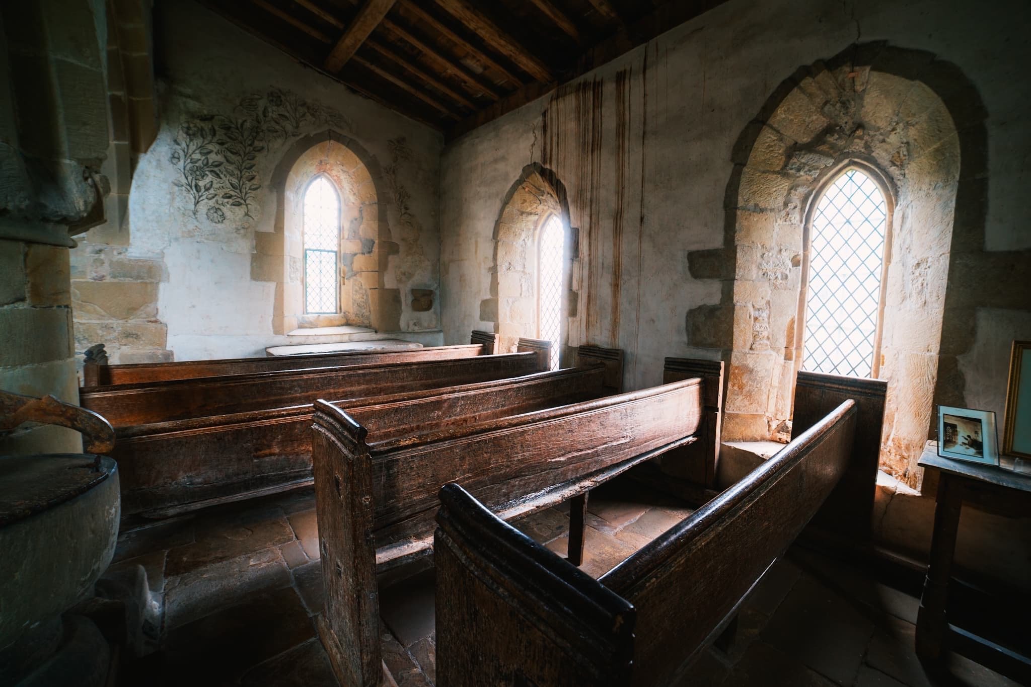
Making our way back to the Banqueting Hall, we crossed the Lower Courtyard to the Chapel of St. Nicholas. It’s a small humble building with Norman origins. The present building was finished in 1427 CE.
The chapel boasts a rare series of medieval wall paintings, most likely commissioned in the early 15th century. The paintings were whitewashed during the Reformation, but became visible in the 19th century and were restored in the early 20th century.
Exquisite and very rare 15th century fresco seccos adorn the walls of the Medieval Chapel.
One last look back across the footbridge to Haddon Hall. You can imagine a horse and cart, carrying esteemed guests, making their way towards the Hall.
Did you enjoy these photos?
Buxton, High Peak, Derbyshire
Buxton. Spas. Spring water.
Buxton. Spas. Spring water.
A certainty on our itinerary when holidaying in the Peak District was to explore the historical spa town of Buxton.
Though almost slap-bang in the middle of the Peak District, Buxton isn’t actually in the National Park. Look…

Buxton, in the Peak District area
Image courtesy of VisitBuxton.co.uk.
This means Buxton has excellent links to other parts of the National Park.
Buxton has been inhabited since the Stone Age, but the first major development of the area came courtesy of the Romans. They named the settlement Aquae Arnemetiae, that is, "Baths of the grove goddess".
Various peoples throughout history have treasured Buxton for its natural geothermic spring, which constantly gushes water out at a steady 28ºC. The town grew in the 18th century due to the Dukes of Devonshire, but it was really in the Victorian era where Buxton drew the crowds. Touring Victorians were attracted to the reputed healing powers of the natural spring.
We enjoyed a long and pleasant meander around the town, on what turned out to be a wonderfully clear autumnal day. Buxton really showed off what it had to offer.
All photos taken on my Sony α7ii using my Sony FE 28–70mm f3.5–5.6 OSS zoom and Rokinon 14mm f2.8 ED AS IF UMC prime lenses. RAWs developed and edited in Lightroom for iPad using Digistock’s Ektar 100 profile.
Buxton, High Peak, Derbyshire by Ian Cylkowski is licensed under CC BY-NC-SA 4.0![]()
![]()
![]()
![]()
We first wandered around Buxton Park before entering the town proper. Beautiful autumn colours were really starting to pop all around the park. Geese were plentiful, too, and clearly very accustomed to humans.
A fellow tourist takes in the view across one of the many ponds and lakes in the park. In actuality, these ponds are all part of the River Wye, which was heavily landscaped in the 19th century.
The park and Pavilion Gardens were opened in 1871, designed by Edward Milner, a well-known landscape architect. He also developed three parks in Preston, Lancashire, amongst many others.
Another lovely English scene, full of ducks, meticulously maintained landscaping, and Victorian architecture.
Buxton Opera House was designed by Frank Matcham in 1903. It’s reportedly the highest opera house in the country. Matcham also designed several London theatres, including the London Palladium, the London Coliseum, and the Hackney Empire.
Buxton saw a decline as a spa resort in the early 20th century. The Opera House re-opened in 1979 with the launch of the Buxton Festival, and the town saw rejuvenation as a base for exploring the Peak District.
Part of the Pavilion Gardens is this 19th century conservatory. Originally, the building was used as a small concert hall, complete with organ. In 1982 it was remodelled as a greenhouse conservatory, with tropical plants and a fish pond.
The Conservatory now houses many beautiful plants, several of which are extremely rare to find anywhere else in the UK.
A visit of Buxton is not complete without checking out St. Ann’s Well and the Pump Room. The room was built in 1894 to dispense the well's water from taps for drinking. Now restored and managed as a Tourist Information Centre, I shot this 10-shot panorama to really take in the Victorian architecture.
Buxton Town Hall, opened in 1889, was designed in the style of a French château. It now houses the offices of High Peak Borough Council.
Around the corner from the Opera House, we found this wonderfully preserved piece of living history: a Victorian chemists’. The shop assistant even showed us a ledger they’ve kept of patients and their prescriptions all the way back to the Victorian times.
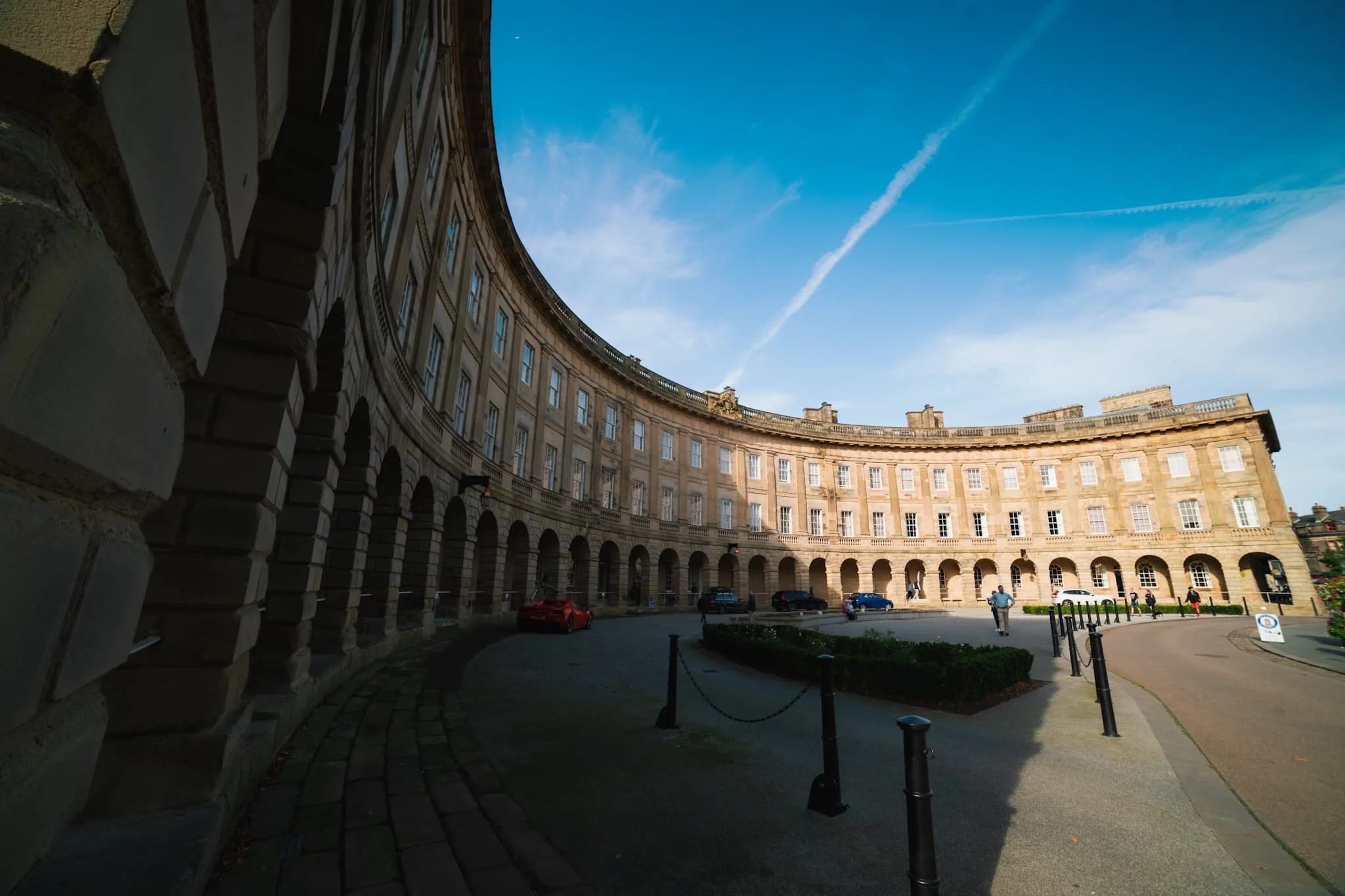
The crowning jewel of Buxton: the Crescent. It is often compared to the more famous Royal Crescent in Bath, but some argue that Buxton’s is “more richly decorated and altogether more complex”.
The Crescent was built in the late 18th century for the 5th Duke of Devonshire. His plan was to elevate Buxton into a popular Georgian spa town. It was built as a unified structure incorporating a hotel, five lodging houses, and a grand assembly room with a fine painted ceiling. By the mid-1980s the last part of the Crescent that was still functioning as a hotel closed due to the high cost of necessary repairs. Then, the whole building was closed when major structural problems were discovered in 1992.
What followed was a couple of decades of the building changing hands, fundraising for essential repairs and upgrades, and consulting on its future. Finally, in October 2020, Ensana reopened the hotel following 17 years of refurbishment.
Did you enjoy these photos?

Lawson Park, Coniston, Lake District, Autumn
We had opportunity this weekend to visit somewhere a little different.
We had opportunity this weekend to visit somewhere a little different.
As we move from Summer to Autumn—with the increase in stormy downpours apparent—the quality of light improves drastically. But before the legendary Lake District autumnal colours arrive, we’re in peak fruit and berry harvesting season. What better way to observe and learn about growing fruit and vegetables than a tour of Lawson Park above Coniston Water?
A small dwelling has been sited on Lawson Park since the 14th century, when the Cistercian order of monks at Furness Abbey emparked the land here and leased out their building to charcoal burners for use in iron smelting.
The ownership of the building and land has changed hands multiple times over the centuries. By the late 1800s and early 1900s, a succession of tenant farmers lived in the farmhouse, kept livestock and worked the hard uneven land around Lawson Park. The last tenant farmer here vacated the property in the 1950s. England’s Forestry Commission bought the property and house in 1947. Liverpool Community College leased the house from the 1970s for use as outdoor and agricultural educational visits.
By 2000, Grizedale Arts director Adam Sutherland leased the farmhouse with his partner Karen Guthrie. At that time the place was little more than a spartan stone house filled with bunk beds including no central heating. They began the process of renovating the farmhouse and creating the gardens that now lushly surround the area, including the help of Japanese rice farmers in 2007.
It’s a fascinating story and I felt very honoured to have the opportunity to photograph it.
Photos taken on my Fujifilm X-T2 using my Vivitar “Series 1” 28–105mm f2.8–3.8 zoom and Laowa 9mm f2.8 prime lens. RAWs converted with Capture One for iPad, developed in RNI Films, and finished in Affinity Photo for iPad.
Lawson Park, Coniston, Lake District, Autumn by Ian Cylkowski is licensed under CC BY-NC-SA 4.0![]()
![]()
![]()
![]()
Lawson Park has no large-scale parking so we had to park at Brantwood ½ mile away and walk along the narrow East of Lake Road before taking the track up towards Lawson Park. That meant we got to enjoy lovely views of Coniston Water and the Coniston Fells in gorgeous light.
Upon locating the forestry track we climbed higher and higher towards Lawson Park. The views over Coniston Water towards the Coniston Fells, and the Old Man of Coniston (802 m / 2,632 ft) in particular, get better and better.
The light and especially the atmospheric clarity were astonishing. I almost felt I could reach across the lake and touch the fells.
Active coppicing around Lawson Park is still very much evident.
The ferns are beginning to turn colour into their autumnal rust.
Inside Lawson Park house. They’ve done a magnificent job bringing up the building to spec.
Not a bad place to spend a dark evening in.
Above the living room is a study room with books galore. Visitors were free to peruse through what they liked.
Of course, the house enjoys magnificent views towards the Coniston fells.
The flowers around the farmhouse were teeming with pollinators.
Karen Guthrie, Residential Warden of Lawson Park. It’s her learnings and vision that have shaped the gardens and land around Lawson Park into the thriving, sustainable, and environmentally-friendly place it is now.
Her guided tour around the land of Lawson Park and her work managing it was fascinating. This included these boardwalks laid to navigate through some of the bogs, made with local larch.
Karen and the other Grizedale Arts folk were keen to onboard and involve young and precocious artistic talent for various projects around Lawson Park, such as this hut built by art students.
A conifer, Picea alcoquiana, native to Japan and very reminiscent of Japanese bonsai trees.

These hydrangea were humming with insect pollinator activity. Even Karen was surprised.
Lawson Park’s vantage point is sensational, here picturing Yew Pike above Coniston village. To the right, an arts sculpture known as The Err, reminiscent of the Bowderstone above Borrowdale.
A simple larch archway in the farmhouse gardens, which will eventually be covered in creeping vines.
Two young lads make drawings of the view before them.
The Kitchen Gardens complete with polytunnels. Fruit and veg grown here feeds the residents and visitors of Lawson Park and supplies ingredients to nearby Farmer’s Arms in Lowick.
The public footpath back through the woods towards Brantwood, the former home of John Ruskin.
The Yewdale fells catch some of the reappearing late afternoon light as we head back to Brantwood.
Did you like these photos?
Trollers Gill & Parcevall Hall, Yorkshire Dales, Spring
Happy belated Easter everyone. Did you have a good 'un?
Happy belated Easter everyone. Did you have a good 'un?
Usually for Cumbria, and the Lake District in particular, Easter signals the first tourism wave of the season. With that in mind, and no obligations to serve, Lisabet and I booked a couple of nights away in a beautiful B&B set in bonny Pateley Bridge, in the Nidderdale Area of Outstanding Natural Beauty.
We took the scenic route to Nidderdale from Cumbria, as we didn't need to check in until the evening. So, first we stopped off at the impossibly pretty Yorkshire Dales village of Burnsall for lunch and some light photography. Afterwards we continued east and stopped off near Grimwith Reservoir for the day's main activity: Trollers Gill.
This place has been on my radar, otherwise known as my Pinterest, for years.
It did not disappoint.
All photos shot on my Fujifilm X-T2 using my three prime lenses: a Fujinon 23mm f/2.0, a Laowa 9mm f/2.8, and an adapted Pentax SMC 55mm f/2.0. Images made 80% in-camera using the Astia film simulation, then finished off in Lightroom and Affinity Photo.
Burnsall
After coffee and a bacon butty near the river, we snapped some shots of Burnsall as we made our merry way back to the car. The 5-arched Burnsall Bridge here is a Grade II listed building, originally constructed in the 17th century with some 19th century improvements.
I'm not sure it's possible to get more Yorkshire than this scene. The Red Lion, built in the 16th century, and recently taken over by Thwaites Brewery.
Like many Yorkshire Dales villages, there's plenty of historical sandy limestone buildings decorated with beautiful greenery, flowers, and the distant hills.
Burnsall Primary School. Originally the old Grammar School founded in 1602 by William Craven of Appletreewick, who later became Lord Mayor of London.
Trollers Gill
After Burnsall, I identified a handy little parking area off the B6265 that would serve as the starting point of our hike to, and up, Trollers Gill. The day was bright and sunny whilst also hazy, lending a wonderful sense of intrigue and distance to photographs. Up on the moorland high above Appletreewick, views extended for miles and miles.
The path down the moorland was easy enough to follow, and soon the characteristic karst limestone landscape of the Yorkshire Dales became apparent.
The main signs pointing to Trollers Gill invite walkers to enter the ravine at the top and scramble their way down. Instead, we elected to take the trail around the western side of Middle Fell. This would eventually lead us to the bottom of Trollers Gill.
The anticipation and excitement builds as we near the bottom of the deep ravine.

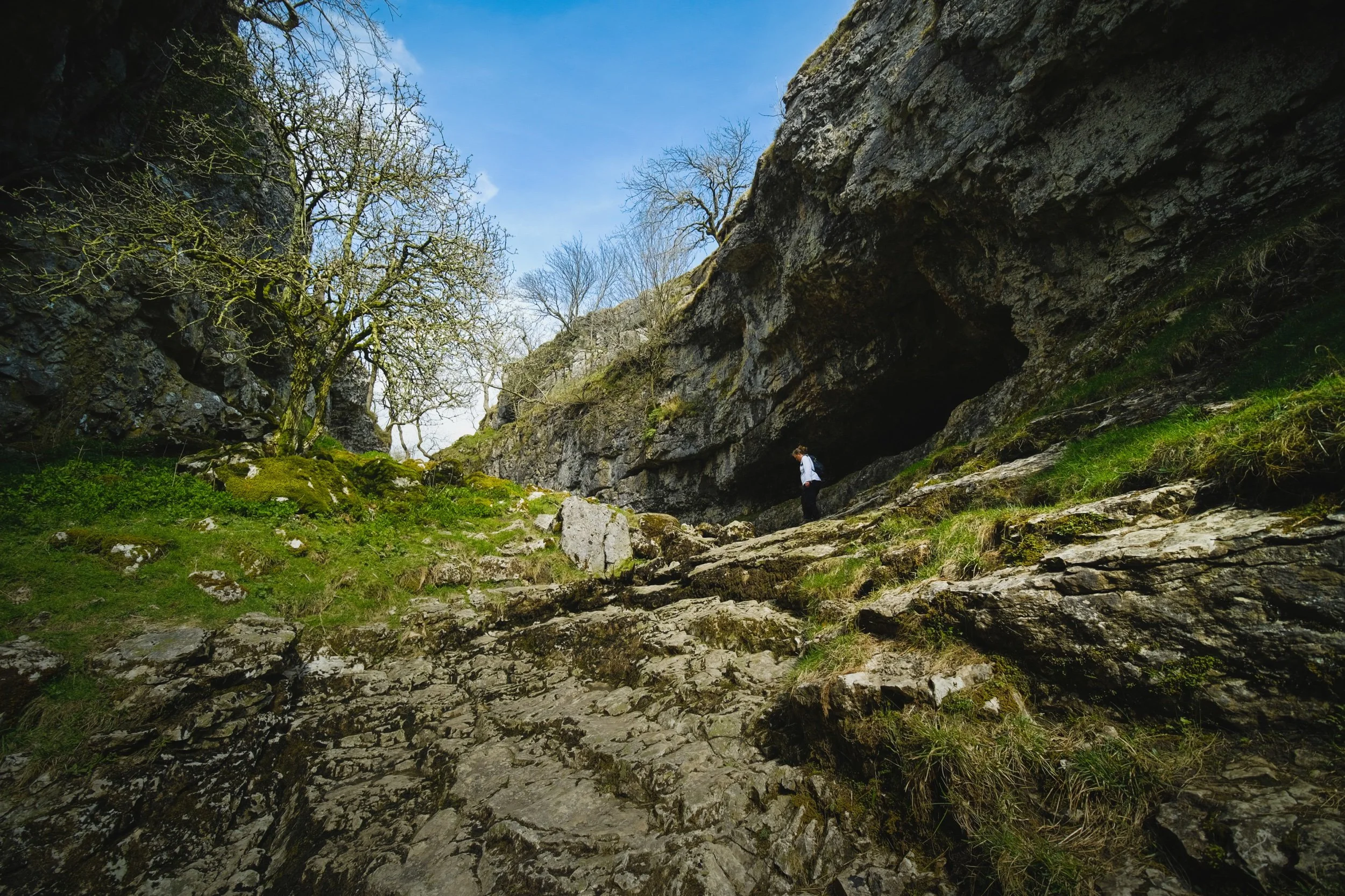
At the bottom of Trollerdale, we followed the minor path north to start the climb up Trollers Gill. But first, I simply had to snap this glorious scene.
The entrance to Trollers Gill, largely dry for most of the year. Historically this would've been the site of a thunderous ravine with several waterfalls and cascades crashing down the gill. Thousands of years of erosion in a limestone landscape means the beck at the top of the gill now goes underground before entering the ravine, later reemerging at the bottom of Trollerdale.
Looking back at our way into Trollers Gill. Fellow hikers gingerly navigate the way down the ravine. Can you imagine this gorge full of water?
As with many other places in the Yorkshire Dales that features sheer limestone walls, Trollers Gill is a favourite for rock climbers.
Rock climbers assist each other as they ascertain routes up the sheer sides of Trollers Gill.
An ultra wide composition looking up from the bottom of what would've been a powerful waterfall. The meaning of the name "Trollers Gill" comes in two parts. "Gill" is already quite well known and used in Yorkshire and Cumbria, sometimes alternatively spelled as "Ghyll". It means a deep ravine or gully, and is cognate with the word gullet. "Trollers" is split into two: "troll" meaning, well, troll, the mythical beast (not the internet variety), and ears meaning "arse". This gives us "the Troll's arse". You're welcome.
Near the top of Trollers Gill, where the beck mysteriously disappears into the unfathomably twisted caves underneath.
Climbing out the gill and up onto the moorland, we realise that the haze has nearly cleared, giving us a fairly clear shot of Simon's Seat.
The deep drop into Trollers Gill that we had just climbed out of.
The single lane "New Road" that connects with the B6265.
A clear sign that a moorland is particularly and consistently wet: rushes everywhere.
One last look back at the farm track that guided us down into Trollers Gill.
A great discovery! Hanging on a branch near our parking spot was this beautifully preserved sheep's skull, probably a Swaledale. We took it home. Isn't it beautiful?
Parcevall Hall & Gardens
After returning to the car, we realised looking at the map that we were very near Parcevall Hall & Gardens. Fancy a quick visit and a wander? Why not?
Parcevall Hall is a Grade II listed Manor House that includes 24 acres of sculpted and maintained gardens. They were created in 1927 but fell into decline after 1960 following the death of Sir William Milner, 8th Baronet of Nun Appleton. Restoration work commenced in the 1980s.

People can visit and explore the gardens between April and October. It enjoys fabulous views and beautiful displays.
Lisabet and I particularly enjoyed this peaceful statue.
The Gardens, amongst other things, are known for their wonderful view of Trollers Gill, so we followed the route uphill.
Still plenty of daffodils around.
And there it is. Trollers Gill to the right and Middle Fell in the centre, daffodils blooming below. What a fantastic scene.
Cherry Blossom in full bloom at the entrance to the Gardens. What a full and gorgeous day.

Berwick-upon-Tweed, Northumberland, Summer
Here’s the final collection of work from our week-long summer jaunt around Northumberland.
Here’s the final collection of work from our week-long summer jaunt around Northumberland.
Berwick-upon-Tweed is a town steeped in history and filled with curiosities. It’s England’s northernmost town, right in the northeastern corner of the country. In fact, it’s slightly further north than Copenhagen in Denmark as well as the southern tip of Sweden.
Berwick’s name comes from the Old English berewíc, meaning “corn/barley farm”, which I guess gives you an idea of the town’s origins. During a period of about 400 years, Berwick changed hands between England and Scotland a dozen times or so. Richard of Gloucester retook Berwick for England for the last time in 1482. More than 200 years later, the Kingdom of Scotland joined the Kingdom of England in 1707, forming the Kingdom of Great Britain, and ending the border quarrelling between the nations.
A persistent legend exists about the town “technically” being at war with Russia. The myth goes that because Berwick had changed hands several times, it was regarded as a special, separate entity, sometimes referred to in proclamations as "England, Scotland and the town of Berwick-upon-Tweed".
For the declaration of the Crimean War against Russia in 1853, Queen Victoria supposedly signed the proclamation as "Victoria, Queen of Great Britain, Ireland, Berwick-upon-Tweed and all British Dominions". When the Treaty of Paris was signed to conclude the war, "Berwick-upon-Tweed" was left out. This meant that, supposedly, one of Britain's smallest towns was officially at war with one of the world's largest powers – and the conflict extended by the lack of a peace treaty for over a century.
In reality, Berwick-upon-Tweed was not mentioned in either the declaration of war or the final peace treaty, and Berwick-upon-Tweed was legally part of the United Kingdom for both.
Regardless, the town is fascinating and you can feel the dual-nationality personality of the place. During our wandering, a sea fret obscured most of the coastline, lending a misty foggy atmosphere to our photography.
All photos shot on my Fujifilm X-T2 using my three prime lenses: a Samyang 35mm f/1.2, a Laowa 9mm f/2.8, and an adapted Pentax SMC 55mm f/2.0. Developed using RNI Film’s Astia 100f profile.
The Royal Tweed Bridge as the sea fret rolled in. It was constructed in the 1920s, designed to take on the increasing numbers of traffic away from the old Berwick Bridge, which had stood since the 1600s.
The nice thing about the Royal Tweed Bridge is you can get right underneath it and see its “guts”, so to speak. An incredible piece of engineering.
One of our favourite shops in Berwick, Slightly Foxed. The interior of the shop is almost made out of books, there’s so many.
The weird leaning/curved building is the old Granary, now serving life as the Granary Gallery.
An unusually empty Berwick, as we make our way towards the sea.
As we approach the North Sea, a look back reveals the three bridges of Berwick, which cross the Tweed.
Old riverside properties as the Tweed pours out into the North Sea.
We decide to venture out towards Berwick Lighthouse, England’s most northerly lighthouse. It was built in 1826.
Time to whip out my 9mm ultra-wide lens to capture the entirety of the lighthouse.
And lurking behind the lighthouse, a fisherman investigating opportunities in the North Sea.
We decide to exit the pier and continue up northwards along the Berwick coastline, see what’s what.
Welp, this was an unexpected find. The bloated carcass of a whale, long dead and washed up on the shore of Meadow Haven. I couldn’t tell you what type of whale it was.
Further up the Berwick coastline we came across an unexpected and delightful find: a raised platform of rocks and boulders known as Meadow Haven and Bucket Rocks. Let’s explore compositions!
I’m always fascinated by how geometric geology like this comes to be formed.
We pop up through the dunes away from the sea to find a way through the golf course and back into the town.
A lovely clump of Red Valerian amongst the reeds and sand dunes, Centranthus ruber.
Story time! As we made our way back through Berwick town, we stopped outside someone’s house to admire their front garden filled with flowers. Lisabet took some photos. As she did, an old gentleman enquired approached us to ask about our activity. After learning we were just admiring his garden, he simply invited us through to their back garden, which was even more fecund and filled with all sorts of flowers and vegetables. The “lady of house” was very enthusiastic about her gardening, and was more than happy to meet us and run through the garden with her. I snapped this quick portrait of her. What a wonderfully welcoming and friendly pair they were!
Her garden was, indeed, glorious.
After the Surprise Garden Tour we made our way towards the old town walls and military fortifications that surround Berwick-upon-Tweed. Local kids enjoy a game of footie sent against the 500-year old fortifications.
Walkways have been constructed around the old walls and fortifications, but there are still sections that have been preserved.
This area of the walls are known as the Elizabethan ramparts, which were essentially 16th-century upgrades to the existing 14th-century construction.
And back down the old cobbled street.
Shibden Hall, West Yorkshire, Autumn
There are some seriously old buildings in Britain.
There are some seriously old buildings in Britain.
We didn’t have an exact itinerary for our recent mini-break but we were given a strong recommendation—by my employer—to check out Shibden Hall, just outside Halifax in West Yorkshire.
Turns out that was an excellent suggestion.
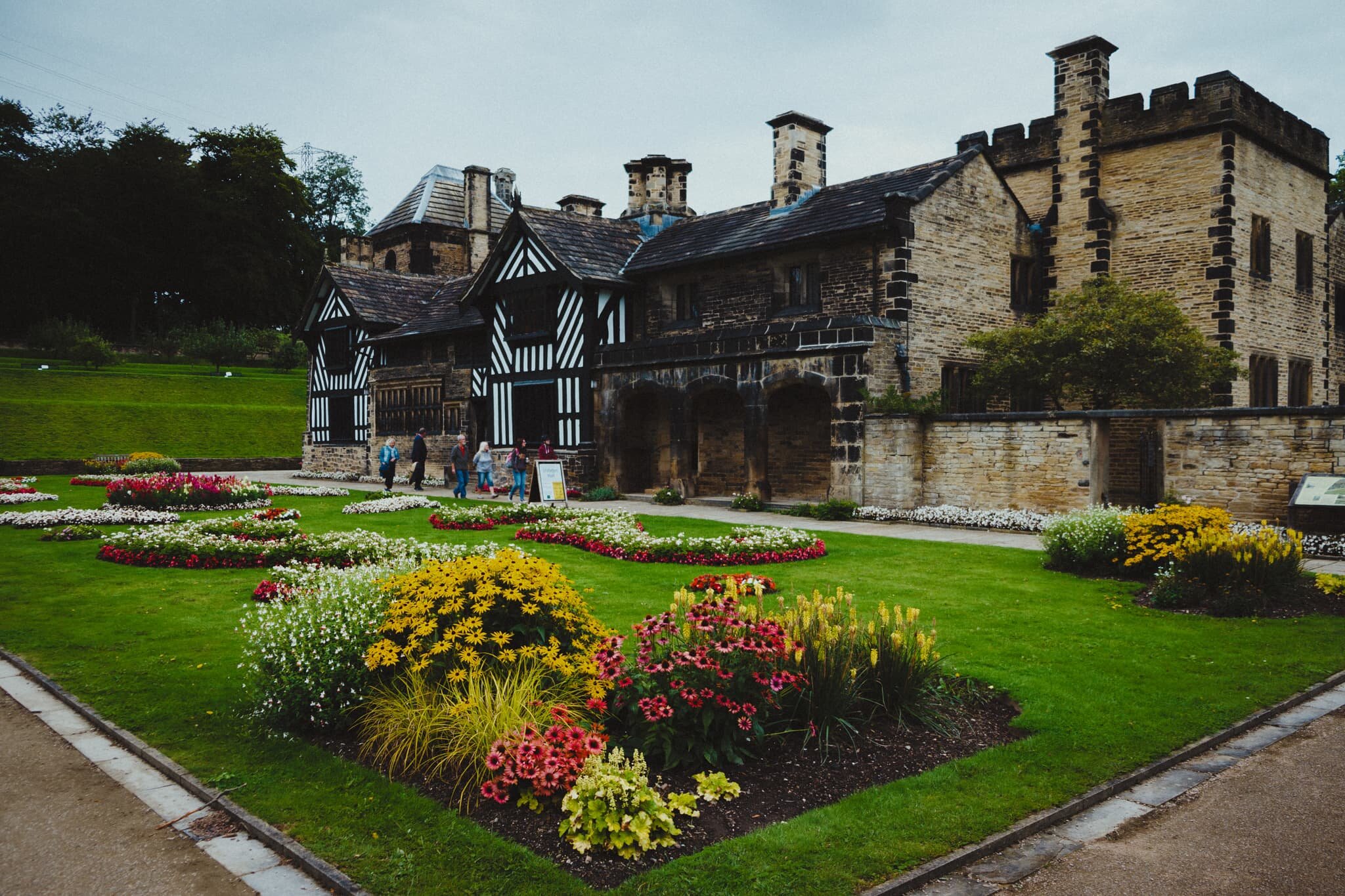
Shibden Hall dates back to around 1420AD when it was recorded as being owned and lived in by the Otes family, making the house around 600-years old. The house passed between families until 1615 when the Shibden estate came into possession of the Lister family, wealthy mill-owners and cloth merchants, who then continuously lived in and inherited the house for the next 300 years.
Perhaps the house’s most well-known inhabitant was Anne Lister, who took charge of the place from 1826 until her death in 1840. She made numerous improvements and additions to the house in her time but more than that she became known as a prolific diarist, writing almost 4 million words. Amongst her recording of daily life in Shibden Hall, as well as current events of the time, a sixth of her diaries were written in a simple code she devised from a combination of algebra and greek letters. These coded entries, later translated by the last inhabitant of Shibden Hall (John Lister), detailed her lesbian identity and sexual relations she enjoyed.
As a result, she is nowadays often cited as the “first modern lesbian” for her honest identity and lesbian lifestyle, despite the openly hostile societal norms of the time.
The history of the families, especially of the Listers, seems almost embedded in the very fabric of the house.
All photos shot on a Fujifilm X-T2 with a Fujinon 18–55mm f/2.8–4.0 lens using a customised Classic Chrome film profile.
Not long after taking charge of the property and estate, Anne Lister hired landscaper Samuel Gray in 1830 to make dramatic improvements to the house and gardens. Now in public ownership, the gardens around the house have been lovingly restored. Despite 600 years of changes and improvements the Tudor-era half-timbered frontage remains its most iconic feature.
The Study, one of the additions Anne Lister made to Shibden Hall.
The Dining Room. One thing that struck me about Shibden Hall was how much wood was used. And also the sheer level of detail in the intricate carvings on the chair backs.
The Guest Bedroom, which overlooked the lawn.
The Red Room. This became Ann Walker’s bedroom, who was Anne Lister’s longest and last partner. They underwent the first same-sex marriage, without legal recognition, in 1834 at the Holy Trinity Church in York. After Anne Lister died, Ann Walker locked herself in this room, fearing eviction; she was shortly declared “unsound of mind” and removed from the house.
The Oak Bedroom. On the bed is a Bed Warmer. Before central heating houses were often cold and damp in the winter. The warming pan was used in beds to warm them and get rid of the damp. It was filled with hot charcoal or ashes from the fireplace and then pushed into the bed.
Behind the house one can access the courtyard containing the original Aisled Barn and the Folk Museum, set up to house and reflect the on-site workrooms that employees of the Shibden Estate worked in. This was the Saddler’s room, who worked with horse equipment.
Around the back of the Brew House, with old carriages.
The Cooper’s workshop. A cooper is a person trained to “make wooden casks, barrels, vats, buckets, tubs, troughs and other containers”.
A Wheelwright’s workshop, who were largely occupied with building and repairing wooden wheels for carts, wagons, traps, coaches, and carriages.
The Apothecary. These days you would call them a Pharmacy (or we tend to say a “Chemist’s” in modern Britain).
This is an example of a Victorian Estate Worker’s cottage. Literally one-up/one-down, these two rooms would house large working families of 7–10 people.
The magnificent frontage and setting of Shibden Hall. What an incredible history.