
Tarn Hows, Lake District, Summer
Summer is upon us.
Summer is upon us.
It’s been a month without any rain, and the temperatures are now consistently in the late teens/early 20s. Rivers and lakes are starting to dry up.
Before things got too crispy and baked, we took a free evening out to Tarn Hows via Tom Gill. Always a good walk, and provides an alternative route to the popular destination that is Tarn Hows. It involves hiking up alongside Tom Gill, occasionally veering off the path to take in a couple of waterfalls. However, they were both almost completely dry.
Tarn Hows was looking incredibly lush and resplendent in its summer finery. One of those evenings that makes you glad to be alive.
All photos taken on my Sony α7ii using my Sony FE 28–70mm f3.5–5.6 OSS zoom lens. RAWs developed in Lightroom for iPad, then edited and finalised in Affinity Photo for iPad.
Tarn Hows, Lake District, Summer 2023 by Ian Cylkowski is licensed under CC BY-NC-SA 4.0![]()
![]()
![]()
![]()
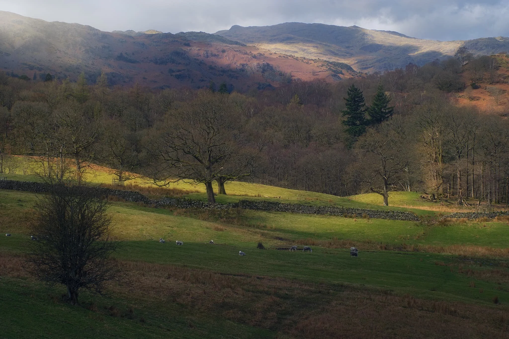
From the upper path around Tarn Hows’ eastern side, my eye catches this fence as a leading line down to the tarn and the Langdale Pikes beyond.
Gorgeous evening light bathes the land and Coniston fells in golden light. In the shade, Herdwick sheep continue their blissful nibbling of the growing grass.
The upper path soon joins the lower one, where we would return back around Tarn Hows. The Grasmere and Fairfield fells peak above the woodland around the tarn.
A panorama, made from 5 vertical images stitched together left to right. I wanted to get all of the dead trees in the frame with the path leading into the distance.
We exited Tarn Hows west via a minor road, and then too came off this road onto a public bridleway, giving us glorious valley views of the Coniston fells.
The road that takes us back home.
Did you enjoy these photos?
Rydal Water, Lake District, Spring
The Lake District is known for many things.
The Lake District is known for many things.
Its lakes, of course. The fells. All the valleys. But also William Wordsworth, who was born in Cockermouth and called the Lake District home for much of his life. It was in the Lake District, wandering along the shores of Ullswater, that Wordsworth took inspiration from the plethora of daffodils along the lake’s shoreline, which ultimately resulted in his most famous poem, “I Wandered Lonely as a Cloud”.
Conscious that the end of daffodil season was approaching, Lisabet and I embarked on a wee circuit around Rydal Water, which I knew to be home to plenty of daffodils. It did not disappoint. Spring is here.
On a separate note, this is also the last set of images taken on my trusty Fujifilm X-T2. With my 40th birthday fast approaching, my Dad did the unthinkable and got me a friggin’ camera for my birthday! A Sony α7ii. Full-frame goodness, here we go.
These photos were taken on my Fujifilm X-T2 using my Vivitar “Series 1” 28–105mm f2.8–3.8 zoom and Laowa 9mm f2.8 prime lenses. RAWs developed in Capture One for iPad, then edited and finalised in Affinity Photo 2 for iPad.
Around Rydal Water there are plenty of areas to choose from when it comes to picking out daffodils for compositions. After one failed attempt behind a bench where I went slip-sliding in the mud, I found this wee clump of yellow beauties and lined up a photo.
Lovely golden light slithers across the rolling fields and the Grasmere fells above.
Below Loughrigg Terrace, a dilapidated barn provides a nice subject looking back to the Ambleside fells.
Did you enjoy these photos?

Kinlochleven, Lochaber, Scotland, Winter
Where to go on the final day of our week long Scottish Highlands getaway?
Where to go on the final day of our week long Scottish Highlands getaway?
We had a few options, but ultimately settled on an area we’d only visited once, the very first time we explored Glencoe in Autumn 2014: Kinlochleven.
Kinlochleven is a small village situated at the eastern end of Loch Leven and completely surrounded by massive mountains. The Loch Leven valley feels more like a Norwegian fjord; a small ribbon lake with mountains rising sheer from the water.
Last time we visited, we barely scratched the service of what there was to offer, largely because of how unfit I was. That situation is a bit different these days, so we embarked on a more more strenuous and adventurous hike.
It were glorious. A great day to end the week.
All photos taken on my Fujifilm X-T2 using my Vivitar “Series 1” 28–105mm f2.8–3.8 zoom lenses. RAWs converted in Capture One for iPad, developed using RNI Films’ Kodachrome film profiles, finalised in Affinity Photo 2 for iPad.
Kinlochleven, Lochaber, Scotland, Winter by Ian Cylkowski is licensed under CC BY-NC-SA 4.0![]()
![]()
![]()
![]()
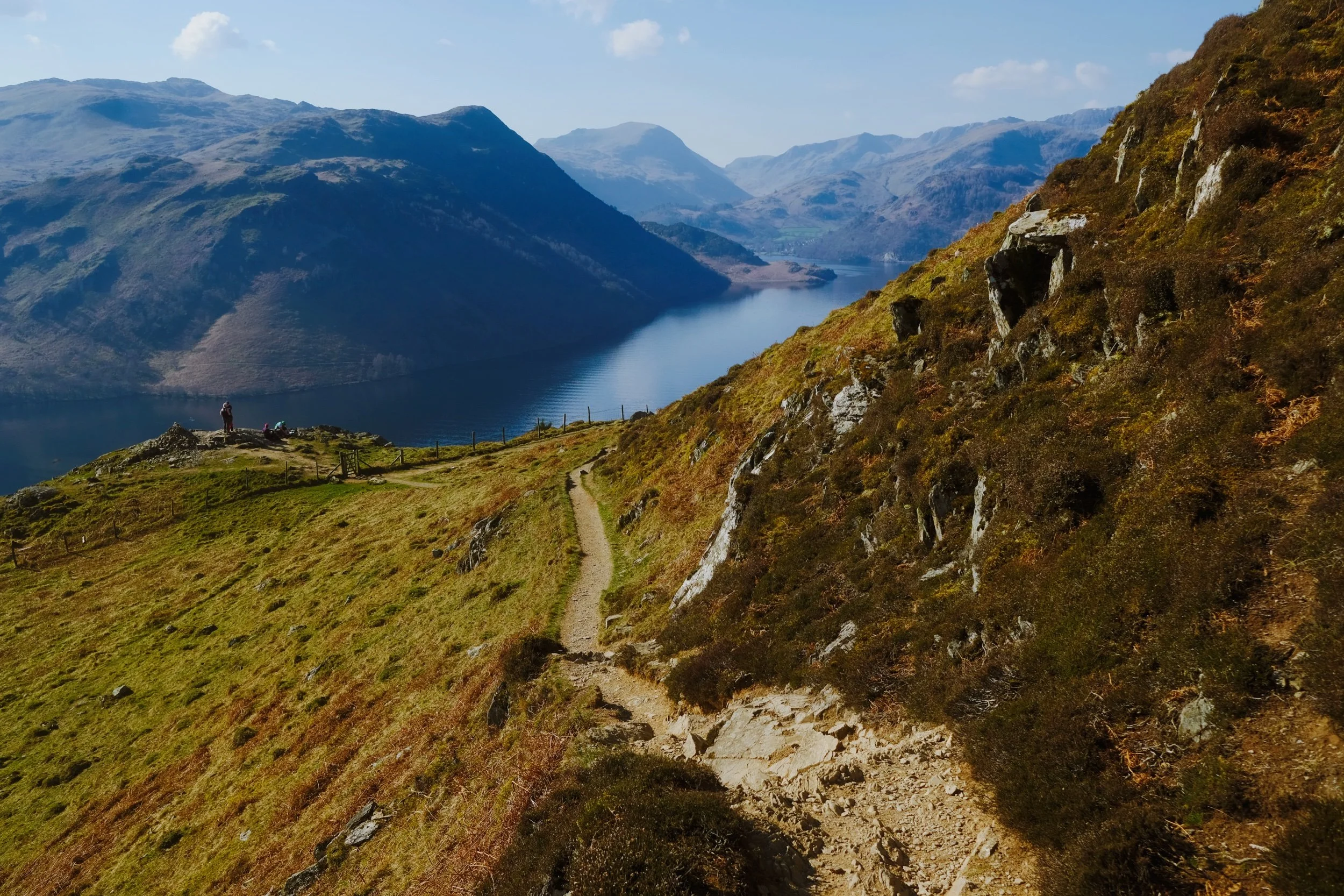
One aspect of the Kinlochleven area we completely missed all those years ago was a large and very accessible waterfall. So this was the first thing to tick off the list. This is Grey Mare’s Tail, which plunges nearly 50m in a single drop. This scene, with a tiny Lisabet gazing upon the falls, put me in mind of some of the photographs I’ve seen of some of the Yosemite waterfalls.
After gingerly picking our way around the falls, it was time to begin the steep ascent up the flanks of Leachd na h-Aire to seek views of the loch and the mountains above it. It didn’t take long before we could see the magnificent shape of the Pap of Glencoe above the loch like a wizard’s hat.
Zooming in for a tighter composition of the Pap, using some of these lovely Scottish pines to the frame the scene.
After a slight wrong turn we used this deviation to our advantage by climbing up onto a small knoll that offered this spectacularly clear view of Loch Leven and her mountains. What a sight. The Pap of Glencoe to the left, and Beinn na Caillich on the right.
A small cluster of Scots pines provide a nice compositional aid, pointing upwards to the magnificent Pap of Glencoe. As the day went on, the light got better and better.
Our goal was to locate the now abandoned Mamore Lodge hotel, which has apparently been left to rot for a decade or so now. Along the way, I snapped one more composition of the Pap.
We finally arrived at the former hotel, and scanned around its perimeter. The lodge was originally built in 1903 for Capt. Frank Bibby, who made his fortune in the Liverpool shipping industry. The aluminium works company, whom essentially created the village Kinlochleven, apparently built the lodge in return for the grant of additional land to house workers back down in the village. Sad to see this.
From the abandoned Mamore Lodge, we were able to locate the small road and follow it all the way back down to the loch, happily snapping compositions along the way.
Beinn na Caillich catching some golden wintersun as we followed the winding road down to the loch shore.
Did you enjoy these photos?
Gowbarrow, Lake District, Spring
Spring has changed very quickly in the UK.
Spring has changed very quickly in the UK.
A couple of weeks ago temperatures barely rose above 10ºC, often settling in at around 5–7ºC. Within the last week, temperatures have suddenly risen to 15ºC with clear skies and barely a breeze. Today, the weather nearly hit 20ºC.
Spring is very weird in the UK these days. That gradual transition from winter to spring doesn’t seem to happen anymore. Instead, after months of sub-5ºC conditions and plenty of rain, you’ll get a week in March or April where it feels a switch has been flicked and temperatures suddenly leap 10 degrees.
Weird.
Well, with a rare free day in current circumstances, Lisabet and I decided to get up early and head to Ullswater for a steep but rewarding hike up Gowbarrow Fell. The last time we visited this fell was back in April of 2021. The weather could not have been more different.
Thankfully, on this occasion, all of my batteries were fully charged and working. What a glorious morning’s hike we had.
All photos shot on my Fujifilm X-T2 using two of my prime lenses: a Fujinon 23mm f/2.0 and an adapted Pentax SMC 55mm f/2.0. Images made 80% in-camera using the Velvia film simulation, then finished off in Affinity Photo.
A dead tree provides a wonderful subject and contrast against the deep blue sky. A flock of Swaledales wearily judge us in the distance.
One of the many deep cascades along Aira Beck at High Cascades, before the river then plunges down the spectacular Aira Force.
These Swaledale yows moved a comfortable distance away from us for a good hard stare.
Beyond High Cascades the path turns east and climbs sharply up the fellside of Gowbarrow. Herdwick sheep were everywhere. I’ve missed those faces.
Unlike Swaledales, Herdwicks aren’t too fussed about being too near humans. I managed to snap this composition of some Herdwicks chilling in the glorious spring sunshine with the Ullswater fells in the distance.
The going was steep, but the views grew increasingly spectacular as we climbed up the fellside.
Aaaaaand summit! The summit of Gowbarrow Fell is known as Airy Crag, appropriately named, and reaches 481 m (1,578 ft) above sea level. The views here are all-encompassing, especially look southwest towards the Helvellyn fells.
I snapped on me 55mm lens for some tighter, zoomed in compositions. From the summit of Gowbarrow Fell and clear view towards Blencathra (868 m/2,848 ft) above Keswick can be appreciated.
After the summit it was a simple task of following the narrow winding footpath around Gowbarrow’s northern and eastern shoulder. In places, the drop from the footpath is rather precipitous.
Lisabet pauses to check on my progress, so I snapped this composition. Truly glory awaits us around the corner…
Hundreds of metres below us the Ullswater Steamers begin the first of many travels across the lake.
And there it is. In my view, one of the grandest views in all of the Lake District. Ullswater and the Helvellyn fells.
Who can resist pausing for a rest and some photos, with a view like that?

Buttermere, Lake District, Winter
It’s time for a mini-break.
It’s time for a mini-break.
We were planning for a Christmas break away in Scotland. But after the emergence and subsequent rise of the SARS-CoV-2-Omicron variant, we decided to cancel it.
One month on, with the situation more clear—and Lisabet transitioning between jobs—we decided to book a few days off and enjoy a long weekend around West Cumbria. We’ll be based near Cockermouth, but on the way we decided to take the scenic route via the Newlands Pass and into Buttermere. A walk around Buttermere’s gorgeous lake was in order.
And what a decision that was! We were greeted with clear blue skies, no wind, gorgeous light, and crystal-clear reflections. A fantastic way to start out mini-break.
All photos shot on my Fujifilm X-T2 using my three prime lenses: a Fujinon 23mm f/2.0, a Laowa 9mm f/2.8, and an adapted Pentax SMC 55mm f/2.0. Images 95% made in-camera, finished for web in Pixelmator and Darkroom. I used Øyvind Nordhagen’s Modern Negative Fujifilm recipe.
The way down into Buttermere after navigating the beautiful Newlands Pass. With the High Stile range in view, excitement levels build.
Honestly, some church builders have a wonderful sense of setting. This is St. James’ Church in Buttermere. The original chapel was built in 1507, with the more modern construction dating from 1840 and restored in 1930.
First thing’s first, we needed to get down to the shores of Buttermere. But when we did, goodness me… I mean, look at it!
From Buttermere’s southern corner, the views back across the lake to the Grasmoor and Newlands fells were astounding.
Looking down Lorton Vale towards Mellbreak, the main fell that overlooks Crummock Water.
Directly across Buttermere, the Robinson fell crags of High Snockrigg and Goat Crag are illuminated in the late-morning wintersun.
Directly above us, the High Stile range looms over our heads.
Buttermere is ringed by so many distinctive fells, but arguably the one that commands your attention the most is Fleetwith Pike, seen here perfectly reflected in Buttermere’s waters.
I decided to play around with some compositions using my ultra-wide 9mm lens.
The path starts to open up as we near the edge of Burtness Woods directly beneath the High Stile range.
The way ahead, with Fleetwith Pike glowing like one of the Pyramids of Giza.
Across the water from Buttermere’s southwestern shore, Hassness Country House is a veritable beacon in the low wintersun.
The point where we turn away from Fleetwith Pike, towards Buttermere’s northeastern side.
The outflow of Warnscales Beck, looking back towards the Crummock Water fells.
High Crag looming above the Buttermere trail. Though not busy, there were a fair few folk wandering around various parts of the trail with us.
At Gatesgarth Farm, the trail becomes the road around the lake, before eventually rejoining the footpath around the northern shore of Buttermere. Before turning away, I get another look at beautiful Fleetwith Pike.
Couldn’t miss the opportunity to nab a composition of this delightful farm cottage set against the High Stile range.
From Buttermere’s northeastern side, the profile of the High Stile range becomes more apparent. There are three main peaks: High Crag, High Stile, and Red Pike.
One of my favourite compositions and views to be found around Buttermere.
A lone tree along the northeastern shore of Buttermere catches the light, a contrast against the deep shadows of the High Stile range.
The shingle beach of Hassness Crag Wood offered a lovely leading line towards Mellbreak in the distance.
A field of Herdwick, happily grazing underneath the craggy wall of the Robinson/Hindscarth Fells.
A clear view of Mellbreak and its reflection.
In order to carry on walking around the northern shore of Buttermere, you need to navigate through Hassness Tunnel.
Popping out of the tunnel, the view back towards Fleetwith Pike and Haystacks was exquisite.
Time for my ultra-wide lens to nab some compositions of the High Stile range, with the sun setting behind them.
With previous cameras and lenses, I was never able to get a good shot of all three of High Stiles’ peaks. Now, with my 9mm ultra-wide, I was able to get all three of them in and more!
My 55mm was able to zoom right in and capture some of the gorgeous detail on Mellbreak.
One last look at Fleetwith Pike in the sunset light.
What a gorgeous day.
Loch Katrine, Loch Lomond & the Trossachs, Scotland, Autumn
The rain finally ceased. So we set our sights on one of our “bookmarks” for this Loch Lomond holiday: Loch Katrine.
The rain finally ceased.
So we set our sights on one of our main “bookmarks” for this Loch Lomond holiday: Loch Katrine.
In particular, our true goal was a small yet isolated hill high above the loch called Ben A’an (461 m/1,512 ft). It’s a very popular hill walk and for good reason: it offers one of the grandest and most spectacular views in all of Scotland (check out the Wikipedia view here).
Unfortunately, at least for us personally, the car park and trail for the hill are being upgraded until the end of December 2021. It’s understandable; both the car park and the trail must take a battering every year.
Instead, we ventured on a loch shore walk along Loch Katrine’s northern and northeastern shore, breaking off every now and then for various compositions.
Despite the lack of ascent, the clarity of atmosphere and glorious conditions more than made up for it. Loch Katrine is 13 km long and only 1 km at its widest point, a true ribbon lake typical of a post-glacial make up. It’s ringed by various peaks all around except for the eastern shore. In particular, Ben Venue (729 m/2,392 ft) looms constantly above the loch’s southern shore, demanding your attention.
All photos taken on my Fujifilm X-T2 using my two prime lenses: an adapted Pentax 55mm f/2.0 and a Laowa 9mm f/2.8 lens. Developed using RNI Films’ Fortia SP film profile.
The booking office, should you wish to go on a delightful cruise down Loch Katrine.
Folk getting ready for a lovely boat ride on the loch. The coats and hoods are to protect against the cold; the day turned out to be gloriously sunny.
Y’know what’s better than a boat? A boat with bunting.
Autumn colours around Loch Katrine are looking proper lush.
Once you move beyond the Trossachs Pier area, the loch opens up and Ben Venue immediately draws your attention. I shot this photo as a vertorama, five separate images top to bottom.
Towards Loch Katrine’s eastern shore reside many small islands. They are noteworthy as being able to look back in time for an idea of what a fully forested valley this would’ve been.
We managed to drop down to the loch shore near Silver Strand for some compositions across the loch. I used my 9mm ultra-wide lens to get this composition looking towards Ben Venue.
Across the loch from Silver Stand is Eilean Molach, or Ellen’s Isle.
Autumn fern popping up amongst the lush forest colours, my Lisabet striding purposefully ahead.
One of many beautiful little cascades that flow into Loch Katrine from the many hills that surround it.
We eventually reached a spit of land—variously known as either Brenachoile Point or Ruinn Dubh Aird—that protrudes out into the loch, affording us fantastic views all the way up and down Loch Katrine. Looking east, the unmistakeable profile of Ben A’an comes into view and I shot this photo; a mental bookmark to return to this area again and summit that hill.
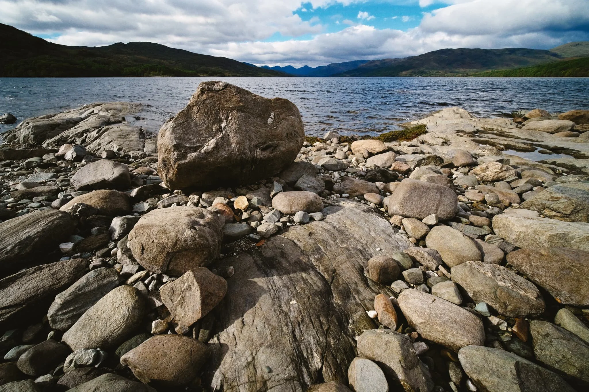
We clambered down to the eastern shore of this spit of land, and I was of course delighted to find various boulders strewn around. On went my ultra-wide lens, and I began making compositions.
In addition, the loch’s water level still hasn’t quite recovered from this year’s remarkably dry summer. As a result, various wave-sculpted rock formations are still visible above the water.
Another sculpted boulder provides an interest foreground subject as contrast against the dark mountains in the distance,
Above the spit’s eastern shore, the last of the year’s heather bloom and a fantastic rock formation give another chance at a different composition.
The boulder in question.
Back onto the loch shore road, I keep my 9mm ultra-wide lens on to nab some compositions looking deep into the forest that looms above the loch.
Beautiful autumnal fern and the looming forest of pines above.
A wonderfully craggy tree that almost seems to grow from the boulder itself.

Further along the loch road, silver birch make an appearance as stark paint brush strokes amongst the autumn palette.
After returning to Trossachs Pier, we moved the car a short distance to the Ben Venue car park. We weren’t about to tackle Ben Venue itself; despite being “only” 700 m high or so, it’s notoriously steep. Instead, a considerably smaller crag—Creag Noran, only a 10-minute walk or so—promised lovely views to Ben A’an, Ben Venue, and across to Loch Achray. It did not disappoint. This is Ben A’an’s southern profile from Creag Noran.
Well, this is glorious. A nine-image panorama of Loch Achray from the top of Creag Noran. Bloody lovely.
My lovely Lisabet, amongst the heather and trees on the summit of Creag Noran.
Looking southwest from the summit of Creag Noran to Ben Venue. Lisabet has the perfect hair for this kind of photo.