Bowderdale, Howgills, Cumbria, Summer
Today required… flexibility.
Today required… flexibility.
My initial plan for the day was to get up early and head to Kentmere for a lovely walk around the valley and its fells. It’s usually a trial to access Kentmere; the road to it from Staveley is long and narrow with few passing places. Then, once you’re at Kentmere, the only place to park is outside the church, fit for maybe 4–5 cars.
Welp, after an interesting challenge driving the narrow road all the way to Kentmere—dodging and manoeuvring past cars and tractors—I arrived at the church to find it completely full of cars.
At 9 o’clock in the morning on a work day.
So that scuppered those plans. What to do instead? I contemplated trying for Longsleddale instead, but that’s an even longer valley with a narrow one-in-one-out road.
I realised that we’ve reached the time of year where the Lake District is always going to be busy, no matter where you go or when. So instead I navigated back to Kendal and took the A685 towards the Howgills. As I was approaching them, thinking of where to explore, I remembered the Bowderdale valley in the northern Howgills. It’s been a long time since I walked in that valley; time to revisit! In fact, it has been exactly four years to the day since I last explored Bowderdale.
Bowderdale is a long north-to-south valley in the northern part of the Howgills. It’s very quiet compared to the Howgills near Sedbergh. It’s also the source of the River Lune, which winds its way north out of the valley, turns sharply west, then gouges its way south where it has carved out the impressive Lune Gorge that now houses the M6 motorway.
I initially fancied a simple hike down the valley bottom. However, the closer to the valley I got, the more I was attacked by a variety of biting flies and insects. I quickly abandoned this idea and retraced my steps back to where the trail connects with the Dales High Way. This would take me up and over West Fell and I would see what I could see of Bowderdale from above.
Turned out to be a good idea! The weather was glorious.
All photos taken on my Fujifilm X-T2 using my Vivitar “Series 1” 29–105mm f2.8–f3.8 zoom lens. Images made 90% in-camera using the Velvia film simulation, finished off in Affinity Photo.
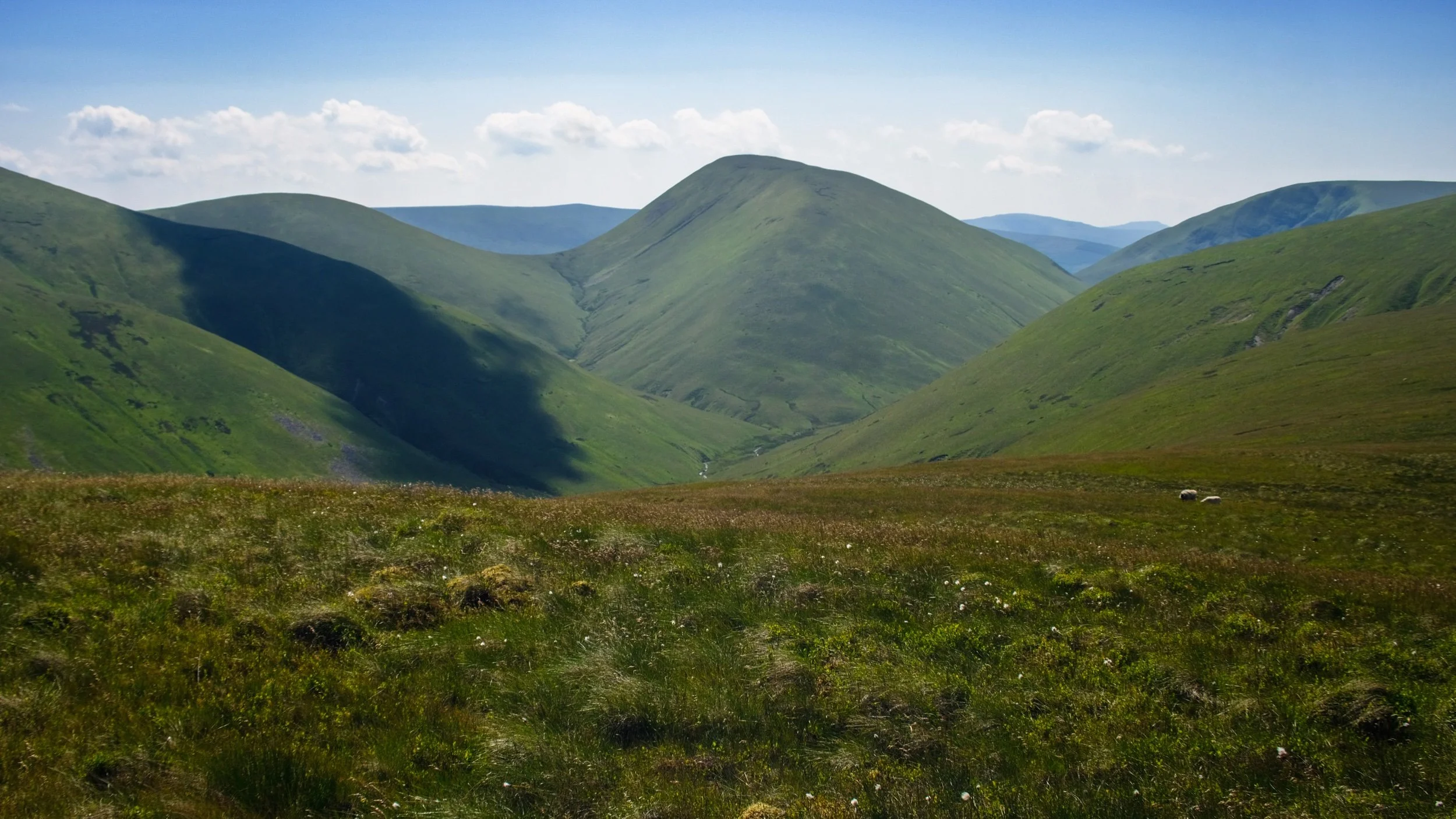
From my car outside Bowderdale village, the scenery was already looking bucolic.
The country lane to Bowderdale village and ultimately Bowderdale itself. The fell in the distance is West Fell (542 m/1,778 ft), which flanks the western side of the valley.
As I was passing through Bowderdale village I could hear some scuffling on the road behind me. I was being followed by a small flock of sheep! I wonder if they were mistaking me for a local farmer or shepherd?
It felt like I was playing a game of Grandma’s Footsteps/Red Light, Green Light/Statues with the sheep. I would turn to look at them, and they’d stop and suddenly find the grass very interesting.
Leaving Bowderdale village, the path climbs up and I catch my first glimpse of Yarlside (639 m/2,096 ft), all the way down Bowderdale.
This was as far as I got on the trail towards the valley bottom, before I was mobbed by biting insects. Time to retrace and look for a different route.
I instead elected for the Dales High Way, which take me up and over West Fell above Bowderdale. Here’s the scene looking back at my progress.
As I near the summit of West Fell, the views west towards Bush Howe above the Langdale valley open up.
On the West Fell ridge, Yarlside comes into view again and the temptation to get a better look proves strong.
Above Yarlside a solitary puffy cloud catches my eye.
Another cloud makes its presence known above Randygill Top.
I neared the eastern edge of West Fell to get a sense of the drop down to Bowderdale.
On the western side of West Fell, East Grain and West Grain join underneath Cobles (534 m/1,751 ft) to become Langdale Beck, which has carved out this beautiful valley.
Looking back north along the shoulder of West Fell to admire the view and track my progress.
It must be noted that this route is probably best tackled in the summer. The trail from the village to West Fell isn’t properly paved, and the fell top shows signs of bogs. This will be a wet and muddy experience in any other season.
Another look west towards Langdale before I crest the summit of West Fell and examine the scene.
The trail drops off West Fell and carries on towards Hazelgill Knott (578 m/1,896 ft) and beyond to the rest of the Howgills. That would be for another day. It was getting awfully hot.
Yarlside in full, which marks the head of Bowderdale. The path at the bottom of Bowderdale skirts around the western flank of Yarlside before dropping down Cautley Spout, one of England’s tallest waterfalls.
I returned to Bowderdale village, and ultimately my car, via the same route, snapping this beautiful bucolic scene.
Bowderdale, Howgills, Cumbria, Summer by Ian Cylkowski is licensed under CC BY-NC-SA 4.0![]()
![]()
![]()
![]()
Did you like these photos?
Great Langdale, Lake District, Summer
It has been far too long since I’ve been to Great Langdale.
It has been too long since I’ve been to Great Langdale.
In fact, from what I can make out, the last time I visited Great Langdale was November 2020. That’s bad.
And a shame. Great Langdale is one of my favourite places in the whole of the Lake District.
Thankfully I have some time off whilst I transition between jobs, and the UK summer is in full swing. It was time to reacquaint myself with some of the Lake District’s most recognisable peaks.
Great Langdale did not disappoint. My goodness.
All photos shot on my Fujifilm X-T2 using my Vivitar “Series 1” 28–105mm ƒ/2.8–3.8 zoom lens. Images made 90% in-camera using the Velvia film simulation, finished off in Affinity Photo.
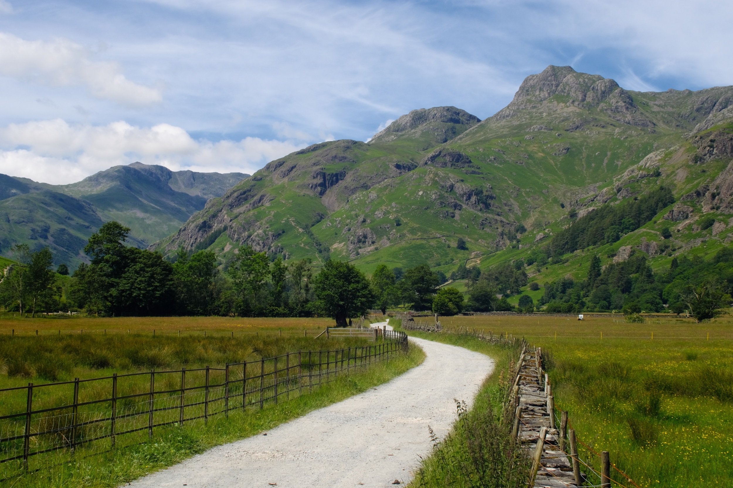
I managed to get some parking at the LDNPA’s official car park, right in the heart of the Great Langdale valley. Merely stepping out of the car park offers you scenes like this.
A true Lake District scene: towering craggy fells, stone walls and cottages, green grass, Herdwick sheep.
There were plenty of ewes and their lambs freely milling around the roads and lanes in the valley.
The first leg of the hike I wanted to explore was to head east towards Oak Howe. This part of Great Langdale is heavy with summer meadows and at this time of the year they’re brimming with flowers. Plus, you get panoramas like this.
I threw my lens wide open and got down low to snap the Langdale Pikes high above the fields and fields of buttercups.
Oak Howe cottage, with Oakhowe Crag towering above, itself a subsidiary top of Lingmoor Fell.
One of my favourite spots in Great Langdale, shot near Oak Cowe cottage next to Great Langdale Beck. The Langdale Pikes looking as epic as ever.
For the second leg of the hike, I traced my steps back west, capturing compositions of the Langdale Pikes along the way.
The fist-like crags of the Langdale Pikes to the right, Bowfell to the left.
Whitegill Crag stands protectively over the valley floor and its inhabitants.
Rossett Farm with Thorn Crag and Loft Crag above, like axe heads thrust into the sky.
The western aspect of Great Langdale features its highest fells, accessible via the fell in the middle of this photo known as “The Band”. To the left is Crinkle Crags (859 m/2,818 ft) and to the right is Bowfell (902 m/2,959 ft).
Some kind of rose, I think? I couldn’t tell you which one but it were pretty, just sitting there in the hedgerow.
As I head closer to Stool End Farm, Pike o’ Blisco (705 m/2,313 ft)—south of Crinkle Crags—makes its presence known.
A pied wagtail (Motacilla alba yarrellii) sits atop a drystone wall long enough for me to focus and nab this shot.
A side valley that branches off the main Great Langdale valley, Mickleden, features this great wall of rock known as Rossett Crag, peaking at Rossett Pike (651 m/2,136 ft).
The road to Stool End Farm, which marks the beginning of many popular ascents up to the likes of Bowfell, Crinkle Crags, and beyond.
The western aspect of the Langdale Pikes peaks at Pike o’ Stickle (709 m/2,326 ft), before dropping sharply down to the valley floor.
Heading back east towards the car, this part of the Langdale Pikes is very popular with rock climbers who fancy tackling some tricky climbs.
I love this place.
Did you like these photos?

Great Langdale, Lake District, Autumn
Do you know what one of my favourite areas in the Lake District is?
Let’s take a break from my recent run of Isle of Skye images.
Do you know what one of my favourite areas in the Lake District is? It’s Great Langdale.
We recently invited my Dad over to come stay with us, as he’s in our support bubble and lives on his own. On the Saturday I took Dad to explore Great Langdale, which he had never seen before. It’s good to know there’s still places in the Lake District I can let my Dad experience for the very first time.
It is an awe-inspiring place. Great Langdale is a fairly flat-bottomed valley that features a northern wall of some of the finest and most recognisable crags and peaks in the Lake District: the Langdale Pikes.
Judging from the amount of photos, I think Dad found it inspiring too.
All photos shot on my Fujifilm X-T2 using both my Samyang 35mm f/1.2 and Laowa 9mm f/2.8 lenses (with some additional help from Dad’s 55-200mm f/3.5–4.8). I used a customised Provia Standard film profile.
It was prime tupping season in the valley bottom of Great Langdale. Plenty of Herdwick yows (ewes) around with one or two tups (rams) doing their… duty.
We experienced some wonderful play of light streaming across the Langdale Pikes. I borrowed Dad’s 55-200mm lens to really zoom on those famous crags. Stickle Ghyll, the series of cascades and falls to the right of the photo, was in full spate.
There were plenty of puddles on the trail, which enabled to shot a composition of the Langdale Pikes I’ve been after for a long time.
More beautiful late afternoon light, picking out the contours and crags of the Langdale Pikes.
To the east of the Langdale Pikes is a wall of fells peaking at Broad Crag and Raw Pike, with a beam of light shooting across the face of the wall.
The trail closed in on Great Langdale Beck and provided me with a lovely leading line towards the glowing tips of the Langdale Pikes.
Nearer the Pikes the swollen beck was reflecting some wonderful light bouncing off the red fells above us. I closed the lens up to get this longer exposure of the flow of the river.
Here’s something I didn’t know about in Great Langdale! Near the Stickle Ghyll Barn Dad and I spotted a small stile that allowed one access over the fence towards these wonderful cascades. I whipped out my 9mm ultra-wide lens for some compositions of these cascades and Whitegill Crag above.
It’s not the Lake District without some idyllic cottages scattered about the valley.
Herdwick sheep are so bloody cute.
A final panoramic look back at the Great Langdale valley; Langdale Pikes to right, and Crinkle Crags to the left.