
The Northern Reaches of Lancaster Canal, Cumbria, Spring
A wet Bank Holiday weekend finally gave way to a glorious evening.
A wet Bank Holiday weekend finally gave way to a glorious evening.
With little time off left, we decided on familiar jaunt that nevertheless is always a pleasure to do: Lancaster Canal’s Northern Reaches.
The Northern Reaches is a part of Lancaster Canal that’s cut off from the rest of the UK’s canal network. In the 1960s, the construction of the M6 motorway north of Carnforth bisected the northern section of the Lancaster Canal, isolating the Tewitfield terminal and leaving the disconnected remnants of the canal to be reclaimed by the natural environment.
For this simple hike we elected to take the route south from Millness Bridge to where the M6 cuts off the canal near Duke’s Bridge. This route offers foliage galore, waterfowl, insect heaven, and fantastic views towards the imposing shape of Farleton Knott.
All photos taken on my Sony α7ii using my Sony 24-240mm F3.5-6.3 OSS zoom lens. RAWs developed in Lightroom, tonemapped in Photomatix, and finalised in Photoshop.
The Northern Reaches of Lancaster Canal, Cumbria, Spring by Ian Cylkowski is licensed under CC BY-NC-SA 4.0![]()
![]()
![]()
![]()
The section of the trail between Millness Bridge and Moss Side is rather muddy and greasy, especially after all the rain we’ve had. However, once you emerge from the tunnel at Moss Side, this lovely view to Farleton Knott finally opens up.
A swan couple, busy feeding from the bottom of the canal, their fresh-faced cygnets milling about aimlessly.
Across the canal, this horse impassively stairs at us.
Nearer Duke’s Bridge, a load of local cows have found their way to the canal for a wee drink.
I zoomed in tight on this beaut, giving us The Eye.
My favourite view anywhere on the Northern Reaches of Lancaster Canal. I managed to capture this reflection of Farleton Knott as the sun started to dip behind us.
A little further up a small gap in the overgrown foliage allowed for another composition of Farleton Knott.
The low evening light catching the tops of the foliage and the bridge. A delightfully idyllic scene.
This dark and shaggy horse posed for me near Marsden Farm underneath Farleton Knott. Couldn’t say no, really.
Did you enjoy these photos?

Oxenber & Wharfe Woods, Yorkshire Dales, Spring
It’s been nearly a month since my last post.
It’s been nearly a month since my last post.
I must apologise for that. Times, they are a’ changin’.
To start, we moved house! That in itself has consumed most of my time and energy, as house moves usually do. Thankfully we’re now all settled in and getting down to the important things in life, like looking at curtain textiles and measuring all the things.
With things settling back down a little, and the British weather drastically improving, we thought we’d try to capture the last of this year’s bluebells. Over the years we’ve found some proper lovely places to photograph bluebells, such as:
This time we tried somewhere new, to us, based on personal recommendation: the woods of Oxenber and Wharfe near Feizor.
And we were absolutely blown away.
Carpets of bluebells, some in ancient woodland, some out in the open with spectacular views to the likes of Moughton Scar and Ingleborough.
Happily, this was also my first full outing with my newly acquired Sony 24-240mm F3.5-6.3 OSS, courtesy of my Dad. This lens easily replaced five other lenses I had, which has significantly reduced my carrying load.
I hope you enjoy these photos as much as I enjoyed taking and editing them.
All photos shot on my Sony α7ii using my Sony 24-240mm F3.5-6.3 OSS zoom lens. RAWS edited in Lightroom, edited in RNI Films, and finalised in Photoshop.
Oxenber & Wharfe Woods, Yorkshire Dales, Spring by Ian Cylkowski is licensed under CC BY-NC-SA 4.0![]()
![]()
![]()
![]()

Our hike started from Austwick and we were soon on the easy well-defined trail towards the elevated Oxenber and Wharfe woods.
A beautiful Holstein Friesian lady, basking in the glorious sunshine.
We followed Wood Lane as the trail started to ascend. Looking back across the segmented fields towards Robin Proctor’s Scar and the Norber Erratics.
The signage was clear enough as to where we needed to go.
Soon enough we began the short and sharp ascent off Wood Lane and into Oxenber Wood. Bluebells everywhere.
This area of woodland and pasture was once an important quarry and source of timber for Austwick. Now it’s marked as an SSSI and largely left to its own devices.
Open areas of former pasture meant acres of bluebells, out in the open, enjoying views towards the likes of Moughton Scar and Ingleborough.
A carpet of bluebells with Moughton Scar on the left and Bargh Hill on the right.
Higher up, more former pasture land has given way to more bluebells. I found this solitary limestone boulder covered in moss that made for a lovely composition.
In addition to all the bluebells were tracts of limestone pavement, much to my delight!
Entering the denser woodland of Wharfe wood, a small trail branched off, giving views towards Moughton Scar.
Wharfe wood’s thicker coverage meant for beautiful soft light and trees covered in moss and lichen.
A small trail heads deeper into Wharfe Wood, with a hint of yet more bluebells beyond. Our route was to exit out of the eastern end of the woodland, but not before I chanced upon this mystical scene.
Popping out of Wharfe Wood, the unmistakable shape of Pen-y-ghent quickly makes itself known to us.
The route now followed the Pennine Bridleway towards Feizor. To the left are the shoulders of the limestone hills above Feizor.
This year’s spring lambs, of the Swaledale kind, quickly scampered to their mums.
On our descent to Feizor I spotted this little cottage and its field covered in buttercups.
The rest of the route back to Austwick was simple enough, just follow the Pennine Bridleway from Feizor to Austwick. This ancient country lane was lined with wild garlic (Allium ursinum) and its delicious smell.
The collapsed ruins of Meldings Barn, with a doorway still standing on its own.
Back at Austwick, the local cows gently made their way to Austwick Beck for a cool down and a drink to relieve from the warm spring day.
Did you enjoy these photos?
Oronsay, Isle of Skye, Scotland, Spring
We’ve only been to the tiny isle of Oronsay once before.
We’ve only been to the tiny isle of Oronsay once before.
This was back in autumn 2020, before the 2nd pandemic lockdown happened.
Conditions on that occasion were cloudy, flat, and grey. But still, the scenery and views were stunning and we vowed to return again.
And so we did, this time with bright spring skies. A world of difference!
Oronsay can be found in Loch Bracadale, along with lots of other little islands, sandwiched in between the Duirinish and Minginish peninsulas. It’s possible to access Oronsay on foot via a tidal causeway consisting of ankle-breaking fist-sized rocks.
Though only 44 acres in size, it features cliffs 240 ft high, which means it offers incredible views to either the cliffs and hills of the Duirinish peninsula, or the cliffs and Cuillins of the Minginish peninsula.
We didn’t see another soul.
All photos taken on my Sony α7ii using my Pentax SMC 28mm F3.5 prime and Vivitar “Series 1” 70–210mm f2.8–4.0 zoom lenses. RAWs developed in Lightroom using RNI Films’ Kodachrome film profiles, edited and finalised in Photoshop.
Oronsay, Isle of Skye, Scotland, Spring by Ian Cylkowski is licensed under CC BY-NC-SA 4.0![]()
![]()
![]()
![]()
From the mainland at Ullinish it’s a simple, if squelchy, walk from the settlement to the coast. The way to Oronsay then becomes clear; at low tide, the sea is parted by a causeway of boulders and rocks.
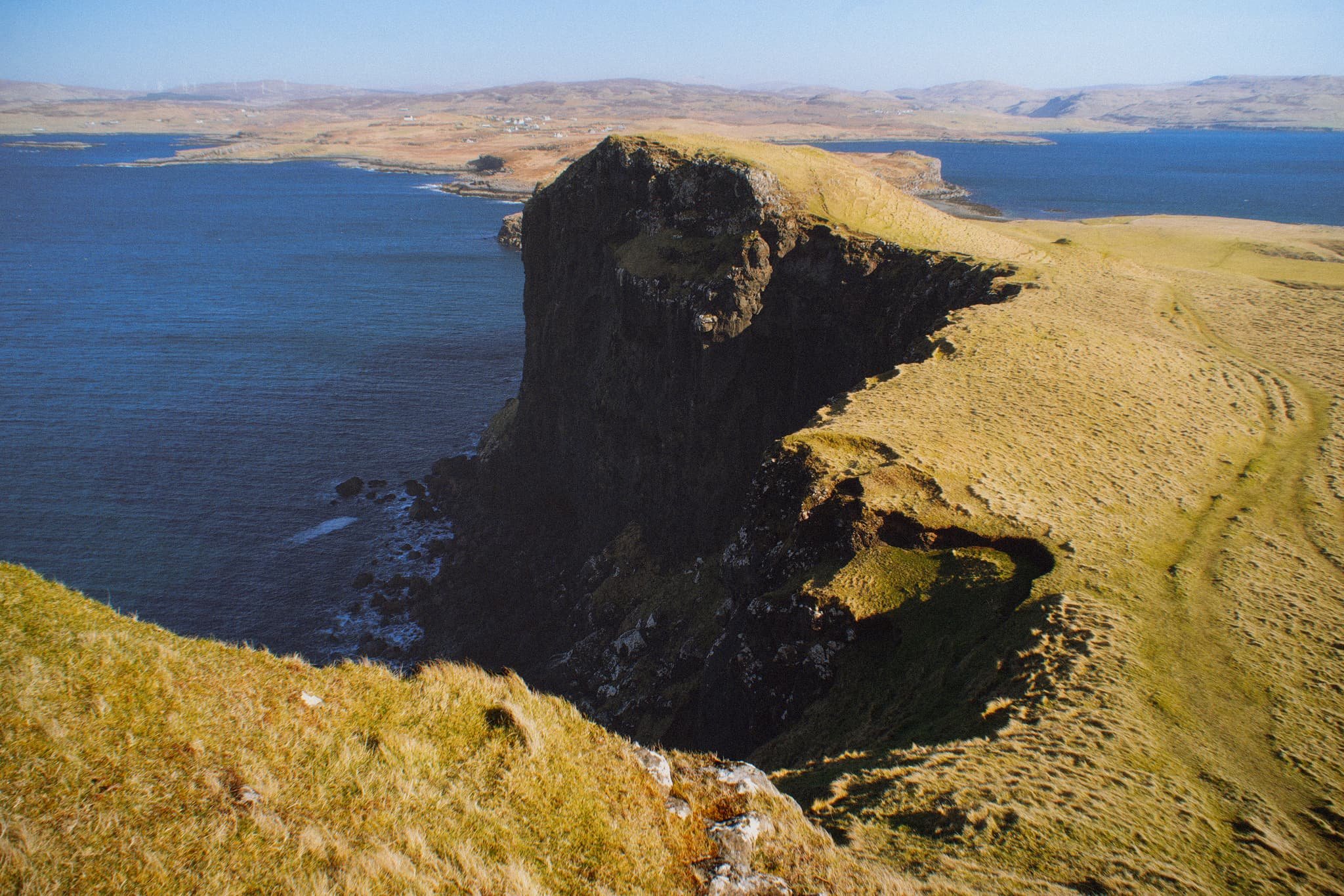
Once on the island it’s simple enough to navigate your way towards the highest cliffs. Once there, you get stunning views like this. Zoomed in, the island of Wiay is clear and you can even make out the cliffs and sea stacks of MacLeod’s Maidens.
Looking further east, the eastern end of Wiay gives way to the two distinctive flat-topped hills on the Duirinish peninsula, known as MacLeod’s Tables. The one on the left―MacLeod’s Table South or Healabhal Bheag―is 489 m/1,604 ft. The one on the right―MacLeod’s Table North or Healabhal Mhòr―is 469 m/1,538 ft.
From Oronsay’s tallest cliff, the view northeast down the island and across the loch all the way to Skye proper is just stunning.
Looking back at the tallest cliff, it’s contrasty shape and shadow is used to frame the distant island of Wiay and Duirinish cliffs.
My little Lisabet hiking her way up to the next cliff, whilst I shuffled as close as I dared to the precipitous edge for this monstrous view.
A simple leading line of Oronsay’s cliff edges, all the way back to Ullinish and the moorlands of Skye.
Returning to the lowest part of Oronsay, I venture around its more boggy eastern area for a view back to the craggy cliffs, again using the harsh light and shadow to aid in a leading line composition.
Did you enjoy these photos?

Grisedale, Lake District, Winter
Happy New Year, everyone! Here’s to a peaceful and gentler 2024.
Happy New Year, everyone! Here’s to a more peaceful and gentle 2024.
Though I’ve enjoyed time off work between Christmas and New Year, it’s not exactly been pleasant. Storm Gerrit washed across the UK, rendering most days miserably wet. There were even tornado warnings, largely unheard of in the UK.
On New Year’s Eve we learned that New Year’s Day promised much nicer conditions, and so we endeavoured to rise early and head into the Lake District for a solid yomp on the first day of 2024.
Conditions were certainly nicer, though you can never predict weather in the Lake District 100%. Hiking along the valley bottom of Grisedale towards the valley’s head, we were washed with wave after wave of fine drizzle. Thankfully, it never rained that hard, and in between the downpours we still managed to nab some glorious photos.
All photos taken on my Sony α7ii using my Pentax SMC 28mm F3.5 and Pentax SMC 55mm f2.0 prime lenses. RAWs developed in Lightroom using RNI Films’ Kodachrome film profiles, finalised in Photoshop.
Grisedale, Lake District, Winter by Ian Cylkowski is licensed under CC BY-NC-SA 4.0![]()
![]()
![]()
![]()
A sign of things to come. St. Sunday Crag (841 m/2,759 ft), rising above a sodden landscape with stormy clouds above.

Much of the first half of hiking into the valley comprised of dodging waves of drizzle. When one cleared up for long enough, I snuck this shot of Eagle Crag and Dollywaggon Pike (858 m/2,815 ft) battling with the low clouds.
Arriving closer to the turning point, we contemplated the condition of the trail on the other side of the valley. The hike in, on the south of the valley, is thankfully paved but had still been rendered in parts as a beck due to all the rain. I knew that the northern path back down the valley wasn’t in as good nick. So, from here, we turned back the same way we came in.
Thankfully, this was also when conditions started to clear up and the Helvellyn range of fells began to reveal themselves.
Eagle Crag with Nethermostcove Beck roaring down the fellside. A project was started in 2021 to return the valley’s main river, Grisedale Beck, back to its original “wiggly” form. To quote the Friends of the Ullswater Way: “As with many rivers in the UK, Grisedale Beck has historically been straightened and reinforced so that fields can be drained to improve grazing. This work was undertaken over 200 years ago and since then we have learned a lot about how straightened and reinforced rivers can negatively affect wildlife and increase flood risk. It should be noted that, despite the historic changes made to the river at the project site, this is still not particularly good grazing land, being very rough pasture and quite boggy in areas.”
Heading back down the valley, we kept turning back at the beautiful view at the head of Grisedale. Primarily to check on any incoming rain washing over the fells, but also to gawp at them. I enjoyed this composition as the trail seemingly leads across the image towards Nethermostcove Beck on the right. Pure mood.
One of the few pines left in the valley points a vibrant branch towards the beautifully cracked glacial erratic.
As the cloud cover finally starts to lift, Falcon Crag and Tarn Crag emerge from behind Dollywaggon Pike.
Light finally breaks through the clouds as we retreat further down the valley.
The beck streaming down from Blind Cove provides a nice leading line towards the vertical face of St. Sunday Crag.

The fells become obscured again. Another wave of rain heads towards us.
As another squall washes over us, I look across to the northern side of Grisedale and spot these bright becks cascading down the fellside. I very quickly nab a photo.
Soon, we near the foot of the valley and the rains were finally done for the afternoon. Look at that mountain backdrop.
Heading back towards the car, the hulking mound of Place Fell catches the warm winter light across its crags.
We elected for the scenic route back to Kendal, heading north out of Patterdale, through Matterdale, and onto the A65. That way we could turn off to head down St. John’s in the Vale and join the A591 back to Kendal. I kept my camera out, with the 55m attached to it, and grabbed this epic scene of Blencathra from the passenger’s side.
Down St. John’s in the Vale, I kept snapping happily, praying that at least one of the shots rendered sharp. Here, the deep cleft of Beckthorns Gill cuts into various crags of Clough Head.
Further south on the A591, near Thirlmere, Fisherplace Gill cuts a deep fissure within the crags of the Helvellyn massif. The farmhouses below look miniscule in comparison.
The distinctive shape of Browncove Crags, a subsidiary top of Helvellyn, with another deep gill caused by Helvellyn Gill.
Did you enjoy these photos?
Ulverston, Cumbria, Winter
It’s been a while since my last post.
It’s been a while since my last post.
Apologies.
I hope every one has had a nice and/or peaceful Christmas.
Following the arctic blast at the beginning of December, the UK has been wet. Two storms washed over the British Isles—Elin and Fergus—bringing with them intense winds and lots of rain.
Being in Cumbria, we got the bulk of the rain.
Finally, on Boxing Day, clear skies and cool temperatures greeted us. We immediately donned gear and head out to the Furness Peninsula of Cumbria. It was time to hike up the Hoad above Ulverston.
It felt good to finally get out and about.
All photos taken on my Sony α7ii, using my Pentax SMC 28mm F3.5 and Pentax SMC 55mm f2.0 prime lenses, plus my Vivitar “Series 1” 70–210mm f2.8–4.0 zoom lenses. RAW images edited in Lightroom using RNI Films’ Kodachrome film profiles, finalised in Photoshop.
Ulverston, Winter, Cumbria by Ian Cylkowski is licensed under CC BY-NC-SA 4.0![]()
![]()
![]()
![]()
Locating the path from Ford Park, we followed it gently up towards the Hoad. Along the way, this group of trees presented a wonderful framing composition of the Hoad.
The trail quickly grew steeper, which also provided fantastic views. From the shoulder of Hoad Hill, the wet autumn and December are evident in the flooded fields near the coast of the Leven Estuary.
Near the top of the hill, as the trail levelled out, we could start making out the Lakeland fells above the Furness hills. The particularly rounded fell centre-right is Wetherlam (763 m/2,502 ft).
Near the monument, outcrops of Bannisdale Slate gave me a wonderful opportunity for some compositions involving the Hoad.
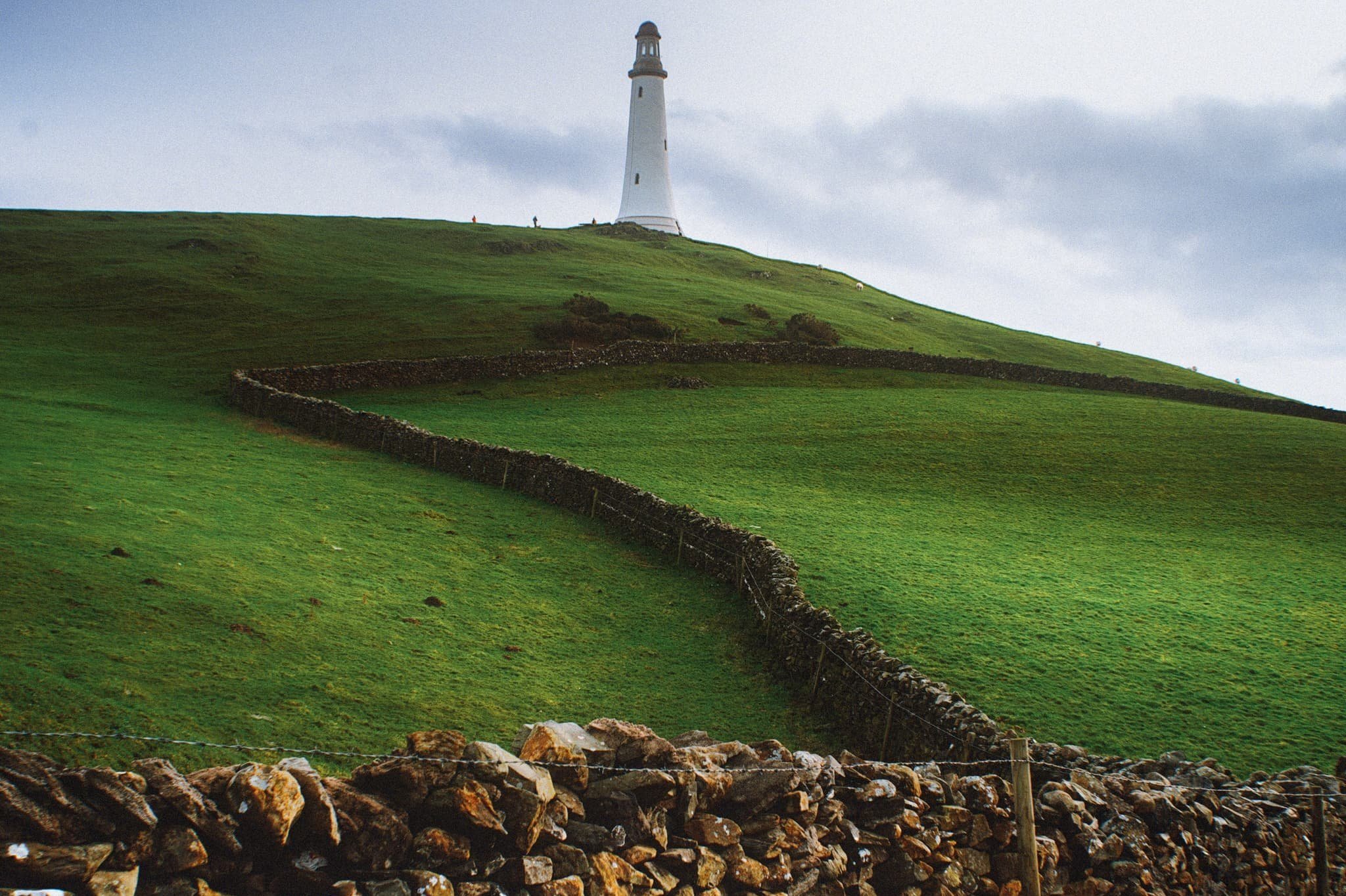
The Hoad goes by a few names. It’s officially known as the Sir John Barrow Monument, but is also known locally as “the Pepperpot”.
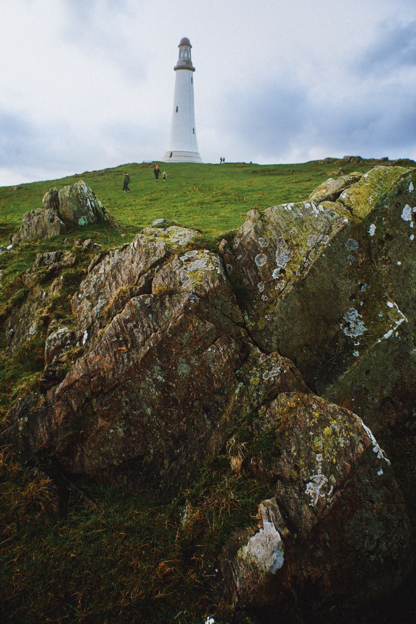
The Hoad was built in 1850 at a cost of £1,250, roughly £138,000 in today’s money. It was built to commemorate Sir John Barrow, who was a founding member of the Royal Geographical Society, and born in Ulverston. Though it looks like a lighthouse, it has never functioned as one.

The views from the Hoad are extensive and panoramic. Plenty of folk were out and about, enjoying a Boxing Day waltz and soaking in the views from the Hoad.
With my 70–210 mm equipped, I was able to pick small sections of Ulverston town. Here, looking southwest from the Hoad, the winding A590 road provides a focal point for the busy architectural landscape of Ulverston.
The view north from the Hoad couldn’t be more different. Rolling countryside, drystone walls, and sheep give way to the mighty Coniston Fells.
Northeast of Hoad Hill, another small hill provides sustenance to yet more sheep. In the distance, the Windermere fells partially obscure the Kentmere fells.
The way back to Ulverston town. You know me, I can’t resist a winding path.
A winding drystone wall catches my eye for a nice composition involving the Hoad.
Back in Ulverston, a wall mural tells the story of Sir John Barrow.
Did you enjoy these photos?

Kendal, Cumbria, Winter
Winter has arrived rather abruptly.
Winter has arrived rather abruptly.
After a week of near- and sub-zero temperatures, the weekend arrived and the snow fell. In Kendal, conditions didn’t seem too bad so we decided to hop int’ car and head into the Lake District proper for some lovely snowy mountain photography.
At Ambleside, we quickly decided we should turn back.
The further we drove into the Lake District, the heavier the snow was. We decided the sensible thing was to turn back and return home. Ultimately, this turned out to be the correct decision. The central and southern Lake District area was buried in snow. 5,000 people have been left without power, and cars have been dumped where they stand, with people seeking temporary shelter.
Today we woke up to a snow covered Kendal. So, we donned our winter gear and some sturdy boots to have a waltz around town whilst we got some errands done.
All photos taken on my Sony α7ii using my Pentax SMC 28mm F3.5 and Pentax SMC 55mm f2.0 prime lenses. RAWs developed in Lightroom using RNI Films’ Kodachrome film profiles. Finalised in Photoshop.
Kendal, Cumbria, Winter by Ian Cylkowski is licensed under CC BY-NC-SA 4.0![]()
![]()
![]()
![]()
My Lisabet, immediately digs in and cleans up for the good of the neighbourhood.
Virgin snow in the courtyard.
Looking back down the cobbled yard to our place. An almost timeless scene.
Families were out in full, making snowmen, throwing snowballs, and sledding on hills.
Abbott Hall, its grounds covered in snow. I love the symmetry of this composition.
The sky attempted to brighten up, but to no avail.
Pleasing shapes and lines created by fresh snow on a winding garden fence.
The picturesque Nether Bridge. I love how timeless this scene is.
Heading back home via Kirkland, the old part of Kendal town. The main road’s been cleared, but I’m sure lots of the minor country roads are still suffering.