
Portree, Isle of Skye, Scotland, Spring
For our 1st full day in Skye, we gradually eased ourselves in.
For our 1st full day in Skye, we gradually eased ourselves in.
Driving 7–8 hours can take it out of you.
So, with pleasing light conditions, we aimed straight for arguably the island’s main settlement, Portree. There’s a fairly well-known hike one can do from Portree, known as the Scorrybreac circuit. You head northeast out of town, take the coastal path below the cliffs of Ben Chracaig, navigate around the corner at Sgeir Mhòe, and follow the coastline towards Toravaig, with magnificent views down the Sound of Raasay and the cliffs of Sìthean a’ Bhealaich Chumhaing. Then it’s a question of hiking up the sharp ascent to Ben Chracaig and onto the path and road back down to Portree.
The views and light around the walk were stunning. Glamaig of the Red Cuillins was coated in snow and clear as a bell.
All photos taken on my Sony α7ii using my Pentax SMC 28mm F3.5 prime lens and Vivitar “Series 1” 70–210mm f2.8–4.0 zoom lens. RAWs developed in Lightroom, then edited and finalised in Photoshop.
Portree, Isle of Skye, Scotland, Spring by Ian Cylkowski is licensed under CC BY-NC-SA 4.0![]()
![]()
![]()
![]()
Upon our arrival at Portree, and parking up at the main car park, the views down Loch Portree towards the snowy Cuillins were already staggering. I quickly attached my longest lens and went snappy happy as the lighshow was constantly changing.
Our goal was to follow the coastal path below the left hill. But before we could get on that, this scene opened in front of me, putting me in mind of the fjords of Norway. I zoomed all the way to 210mm to get a real tight composition, involving the flanks of Ben Chracaig to the left, the crags of Ben Tianavaig to the right, and the hills of the Isle of Raasay in the middle.
On the trail, the sound of rushing water caught our attention. We quickly nipped off trail and followed the sound, locating this beautiful and totally unexpected waterfall! These unnamed falls belong to the River Chracaig as it tumbles down the hills above.
As we rounded the corner at Sgeir Mhòr, this magnificent view down the coastline to the illuminated cliffs of Sìthean a’ Bhealaich Chumhaing appeared.
We followed the trail further down the coastline until it abruptly turns inland near this area of flat land. The path then zigzags up the steep hillside of Ben Chracaig. Halfway up, lighting conditions changed and I quickly nabbed this dramatic shot.
Away from the cliffs and onto the moorland above Portree, this frankly ridiculous scene revealed itself to us. The Storr, lightly dusted in snow, with a thick and dramatic storm above, whilst the Portree moorlands and this house receive a strong burst of sunlight from behind us.
Back at Portree the light continued to change dramatically, with the clouds lifting above the Cuillins. I zoom in tight on this composition of Portree harbour as the light broke through the clouds enough to highlight the snowy Cuillins.
Did you enjoy these photos?
Holy Island/Ynys Gybi, Anglesey, North Wales, Spring
After getting some delicious mountain action, it was time to head back to the coast.
After getting some delicious mountain action, it was time to head back to the coast.
Anglesey is the largest island in Wales, and the 7th largest in Britain, separated from the North Wales by the narrow Menai Strait.
If you travel across the island all the way to its northwestern tip, you can cross the Cymyran Strait onto a much smaller island called Ynys Gybi, or “Holy Island” in English.
Ynys Gybi features a rocky coastline full of cliffs and rises to 220m/722ft at Holyhead Mountain. Much like Inception, there are an additional two islands off Ynys Gybi: North Stack and South Stack.
Our hiking for the day involved checking out Rhoscolyn Headland, then onwards to revisit the epic South Stack and its lighthouse.
The day was full of low cloud and a dramatic mood.
Photos taken on my Sony a7ii using my Vivitar “Series 1” 28–105mm f2.8–3.8 zoom lens. RAWs developed in Lightroom for iPad, then edited and finalised in Affinity Photo 2 for iPad.
Holy Island/Ynys Gybi, Anglesey, North Wales, Spring by Ian Cylkowski is licensed under CC BY-NC-SA 4.0![]()
![]()
![]()
![]()
Unbeknown to us, Rhoscolyn Head is world-renowned for its fascinating geology. As an amateur “rock nerd” myself, I was delighted with what I found. Here, I found a cliff edge covered in wildflowers, looming over Porth Gwalch.
Fascinating shards of rock like plates of armour line this cliff as a strand of light escapes the thick cloud cover.
Rhoscolyn Head is known for its exposures of the South Stack formation of rocks. These are Cambro-Ordovician metasedimentary rocks, which demonstrate unusual foldings at certain places, such as here.
The day was moody, thick with cloud and moisture, and this added to the dramatic scenes we explored at Rhoscolyn Head.
A resident of Ynys Gybi we did not expect to see! Goats.
Rhoscolyn Head is also known for two sea arches that have been carved out of the cliffs over the course of millennia. After sighting this one from above, we scrambled down the cliff side for a closer look. This is Bwa Gwyn, “the white arch”.
Further along the headland we find the vast gaping maw of Bwa Du, “the black arch”. In the far distances, on the left, is Holyhead Mountain, the highest point on Ynys Gybi at a gentle (220 m/720 ft)
The other side of Bwa Du, with the sun desperately trying to break through the dark cloud cover.
At Gromlech, this lovely little cottage enjoys extensive views across the Irish Sea and onto these folded metasedimentary rocks below. Pure drama.
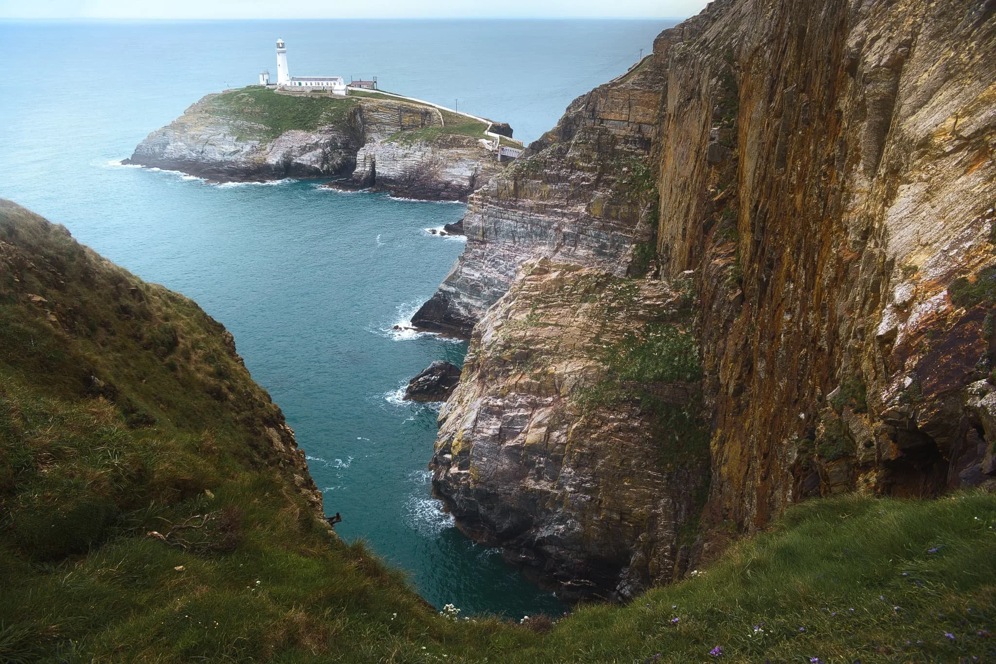
After circumambulating around Rhoscolyn Headland, we drove further up the coastline of Ynys Gybi to revisit a favourite of ours: South Stack. This is a tiny rocky island just off the cliffs of Ynys Gybi, and is home to a picturesque lighthouse. Access is via steep and winding steps that navigate down the sheer cliff face. Every now and then, you get incredible views across the cliffs as you head down the steps.
South Stack lighthouse, shot from higher up the steps. The lighthouse was constructed in 1809 and finally automated in 1983. To begin with, the sole means to traverse to the island was via a basket hung from a hemp rope. Subsequently, in 1828 an iron suspension bridge was constructed, which was then replaced in 1964 by a steel cable truss bridge. Nevertheless, in 1983 it became necessary to close the bridge to the public due to safety issues. Finally, after an aluminium bridge was built, the lighthouse was reopened for public access in 1997. At present, it has become a favoured tourist attraction, drawing many thousands of visitors annually.
Further south from the lighthouse, one can take the path from the RSPCB building down the cliff to Ellin’s Tower, then enjoy a wander along the cliff tops there. A sheer from near Ellin’s Tower gave me this dramatic composition looking back at South Stack and its lighthouse.
Elin’s Tower and, further, South Stack Lighthouse in the distance, with gorse (Ulex europaeus) flowering everywhere. Unusually, gorse in the spring has the strong scent of coconut. Elin's Tower is a Victorian stone tower. This castellated architectural extravagance, initially employed as a summer residence, was constructed between 1820 and 1850 for the prominent Stanley family of Penrhos. It derives its name from Elin (anglicised as "Ellen"), the Welsh spouse of the 19th-century statesman William Owen Stanley.
Did you enjoy these photos?
Conwy, North Wales, Spring
Conwy is a historical treasure trove.
Conwy is a historical treasure trove.
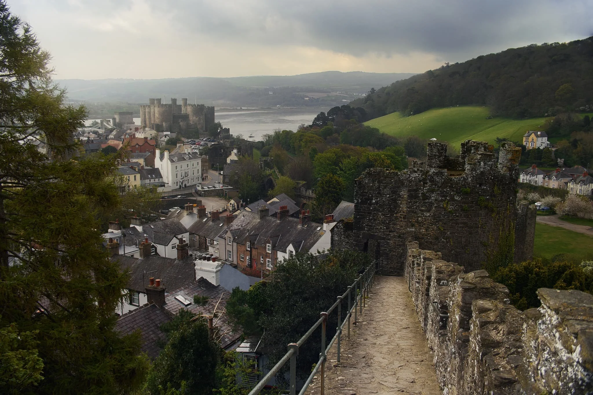
Situated above the river of the same name, Conwy is a walled town with most of those structures surviving to the present day. The town is perhaps best known for its castle, which was built along with the walls in the late 13th century.
We enjoyed getting lost around the myriad of small streets in the town, but eventually climbed up the town walls and followed the circular trail on top of the walls, which mostly surround the town. The walk offers unparalleled views of the town, the castle, and the estuary beyond.
Add a hazy day with localised and shifting spot lighting, you’ve got conditions set up for some gorgeous photos.
All photos taken on my Sony a7ii using my Vivitar “Series 1” 28–105mm f2.8–3.8 lens. RAWs developed in Capture One for iPad, edited and finalised in Affinity Photo 2 for iPad.
At the junction with Upper Gate Street, I zoomed in on this composition of Upper Gate tower, standing imperiously above the street’s housing.
The section of the walls heading towards the Quayside allow for fantastic views across Conwy’s rooftops towards the imposing 13th century Conwy Castle.
Approaching the Postern Gate, a view straight down Castle Street being lit by the brightening day proved irresistible.
At Lower Gate this beautiful house provided the perfect foreground subject to complement the light show happening across the Deganwy hills.
Heading down from the Watchtower, I find another composition that—to me—sums up Conwy nicely.
Did you like these photos?

Hodbarrow Nature Reserve, Cumbria, Autumn
Time for somewhere a little different.
Time for somewhere a little different.
For a little while now we’ve had our peripheral vision on a little-known nature reserve in southwest Cumbria: Hodbarrow Nature Reserve.
Today was the day to visit and explore it.
The nature reserve occupies the site of a former iron ore mine, which was in operation until the 1960s. The RSPB purchased the nature reserve in 1986, and are managing the area to sustain numbers of terns, wintering red-breasted mergansers, as well as wintering teals, coots, little grebes, redshanks and dunlins, and breeding great crested grebes. They are also looking to re-establish the nationally rare natterjack toad.
While parts of eastern Cumbria and North Yorkshire were looking cloudy and rainy, the southwest Cumbrian coast at Millom was thankfully sunny and clear, with gorgeous painterly high-altitude clouds aiding our photos.
Photos taken on my Fujifilm X-T2 using my Vivitar “Series 1” 28–105mm f2.8–3.8 zoom and Laowa 9mm f2.8 prime lenses. Images are 90% made in-camera using Shark & Palm’s “Kodak Ektar 100” film recipe. Finalised using Affinity Photo 2 for iPad.
Hodbarrow Nature Reserve, Cumbria, Autumn by Ian Cylkowski is licensed under CC BY-NC-SA 4.0![]()
![]()
![]()
![]()
What became immediately obvious to me and Lisabet upon our arrival was how quiet the nature reserve was. Absolutely delightful.
Beautiful “brush stroke” clouds decorated the skies above the flooded “lagoon” of the nature reserve.
The fell that commands your attention all around the nature reserve is Black Combe, an isolated Lake District fell of 600m high.
However, further into the distance are the Coniston fells, looking sublime as the clouds cast painterly shadows across the slopes of the fells.
An old abandoned lighthouse, possibly abandoned in favour of the newer one further southeast of the nature reserve. The little stub of a building in the distance to the right is the ruins of a windmill. The old windmill was used by Hodbarrow Iron Ore Mine to store gunpowder, used for blasting, between 1855 and 1880, when a purpose-built facility was built.
A clearer panorama of the Coniston fells.
A crackin’ composition I couldn’t resist. The old lighthouse reflected in the lagoon with the hump of Black Combe in the distance.
The crags of Hodbarrow Point, subject to constant erosion by the tides of the Duddon Estuary, itself connected to Morecambe Bay.
Beautiful strokes of painterly clouds adorn the skies above Black Combe. Attached to the nature reserve’s lagoon is the Hodbarrow Marina.
An old couple enjoy the views across the Duddon Estuary as feathery clouds streak across the sky.
As we approached the newer lighthouse, I noticed lots of large puddles nearby the enticed me to try my hand at a reflection composition. Not bad.
The “lagoon” of the nature reserve is protected from the sea by this beautiful sea wall, built in 1905.
Faded grandeur. Plus the streaky clouds enabled an ultra-wide composition as they “pointed” towards the lighthouse.
From the top of the sea wall, the ever-stretching expanse of Haverigg beach comes into view.
Looking along the sea wall all the way back to the Furness peninsula.
A simple scene, but beautiful nonetheless.
I enjoy the way the curve of the lagoon is mirrored in the curves of the clouds above.
After lunch, we re-emerged into the nature reserve with considerably more cloud cover. The Lakeland fells, however, were still looking magnificent.
The clouds grew larger and tighter around the sun. That would be it for the day.
Did you enjoy these photos?
Mumbles, Gower, South Wales, Autumn
A last burst of summer in autumn.
A last burst of summer in autumn.
For our second full day in South Wales we decided to check somewhere we’d never been to before on our previous South Wales explorations: Mumbles.
Mumbles (or Mwmbwls in Welsh) is a headland on the western edge of the Swansea Bay, right on the southern coast of Wales. It has an unusual name, don’t you think? There are different thoughts of where the name comes from:
Exploring French sailors may have named the two rounded islands off the headland les mamelles, meaning “the breasts”, which became corrupted over time;
It could come from the Latin Mamucium, taken from an older Brythonic name, with the mamm- aspect meaning, yes, “breasts”.
We started our hike at Bracelet Bay and the day greeted us with clear skies and a very warm sun. After wandering around the bay and hiking up the limestone crag above the bay—nabbing photos along the way—we carried on the Wales Coast Path west towards Langland Bay.
The views along the way were fantastic. It did not feel like October.
All photos taken on my Fujifilm X-T2 using my Vivitar “Series 1” 28–105mm f2.8–3.8 zoom and Laowa 9mm f2.8 prime lenses. RAWs developed in Capture One for iPad, edited and finished in Affinity Photo for iPad.
Mumbles, Gower, South Wales, Autumn by Ian Cylkowski is licensed under CC BY-NC-SA 4.0![]()
![]()
![]()
![]()
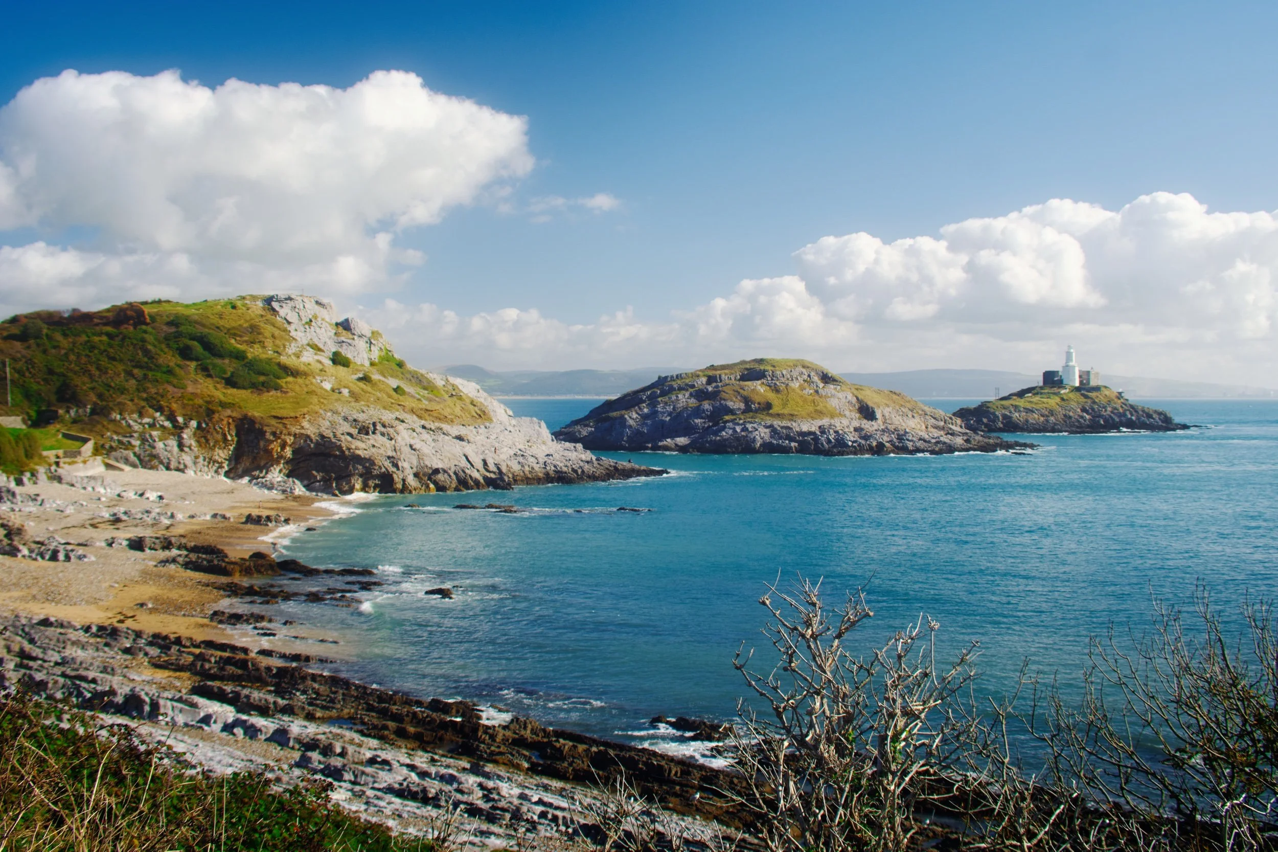
Bracelet Bay, with Mumbles Head to the left, Middle Head dead centre, and Mumbles Lighthouse to the right. You can see why breasts are historically mentioned often in the etymology of Mumbles.
A 9mm ultra-wide composition made from two focus stacked frames of some gorgeous rock samphire with Middle Head and Mumbles Lighthouse in the distance.
Wave-sculpted crags and boulders provided a lovely frame of the Mumbles islands.
I shot a multitude of ultra-wide frames for this composition here, seeking to find the “optimum” way the sea crashed around this sea stack.
We climbed up Mumbles Head for more expansive views of Middle Head, Mumbles Lighthouse, and beyond. Two other guys already there were deep in solemn conversation.
My lovely Lisabet high above the crags of Mumbles Head. Middle Head and Mumbles Lighthouse were starting to catch the sun as it appeared behind the clouds.
An alternative composition as we climbed further up Mumbles Head, with Middle Head attracting the full attention of the sun from behind the clouds.
With the sun dipping behind the clouds again, softer light caressed the shoulders of Mumbles Head and Middle Head. Although breasts are often evoked when viewing these islands, to my mind they’re more like whales of some nature.
Beyond Bracelet Bay we followed the Wales Coast Path west towards Langland Bay. It was turning out to be a corker of a day, the sea glowing a deep aquamarine.
At Rams Tor, looking into the distance at Snaple Point, Whiteshell Point, Pwlldu Head, and Oxwich Point.
Glorious Langland Bay, lined with beach huts and seafront villas. Clearly a popular holiday spot.
The crags of Rothers Torr below the cliffs of Langland Bay.
Allonby Bay, Cumbria, Spring
We’re taking a week’s break in Western Cumbria.
We're taking a week's break in Western Cumbria.
After arriving at the accommodation near Wigton, meeting the owners, and settling in, we decided an evening stroll at nearby Allonby Bay was in order.
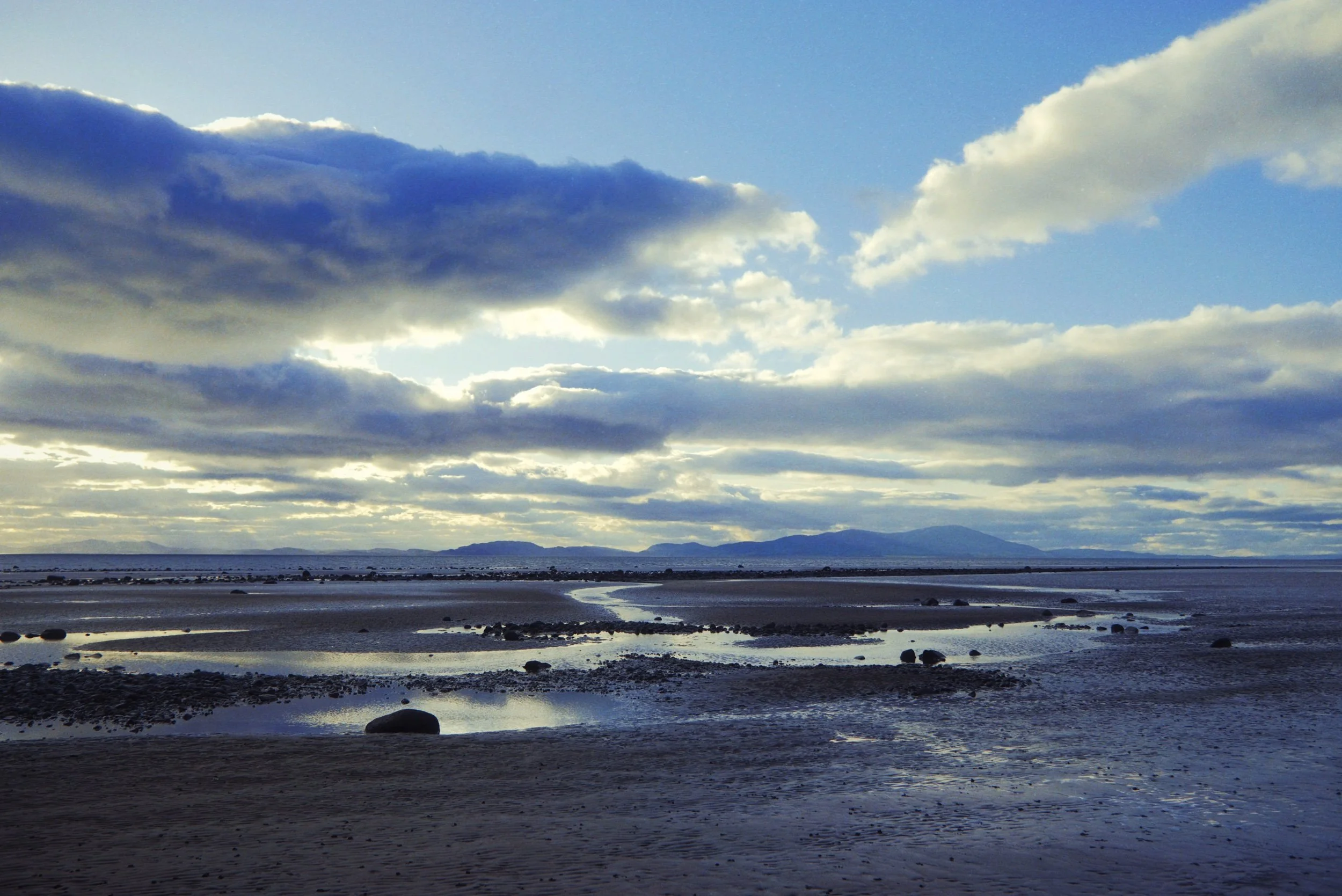
Allonby's a small coastal village on the western coast of Cumbria, roughly halfway between Maryport and Silloth. It's an unassuming place, once home to a small fishing fleet. Nowadays, knowing tourists can come off the main roads to find this little treasure near the Solway coast and its amazing views across the Solway Firth towards the Galloway mountains in Scotland.
Photos shot on my Fujifilm X-T2 using my three prime lenses: a Fujinon 23mm f/2.0, a Laowa 9mm f/2.8, and an adapted Pentax SMC 55mm f/2.0. Images developed using RNI Films' Agfa RSX II 200 film profile.
Across the sea, as the sun was setting, Criffel hill is clearly seen as it looms over the Scottish coast.
A winding channel snakes out from Allonby towards the bay.
Crepuscular rays emerge from the heavens and cast golden light on the sea.
One of my favourite compositions of the evening.
Looking south down Allonby Bay, the golden clouds serving as a wonderful leading line.
Little pools in the rippling sand made for beautiful reflections of light and colour.
Finally, the setting sun came out from behind the clouds strong enough to pull out the textures in the rippling sand.
As the sun started to disappear behind the clouds, we navigated away from the sands and back to the village. The coastline near the village is bordered by these reeds, which I needed to make a composition of.
The reeds were also home to some beautiful flowers that we didn't expect to see.
A gorgeous start to our break.