
Sleat Peninsula, Isle of Skye, Scotland, Spring
Skye’s Sleat peninsula often gets overlooked.
Skye’s Sleat peninsula often gets overlooked.
It’s understandable why. When the island contains wonders such as the Cuillins, the Quiraing, the Storr, the Fairy Pools and more, why would you go to the extreme south/south-west of the island?
In my experience, Sleat is where you take photos from, not of. While the peninsula does have some lovely coastline, arguably it’s finest aspect is the views you can get from its southern and northern shores.
Looking south across the Sound of Sleat one can enjoy immense views of the Knoydart mountains, such as Ladhar Bheinn, Meall Buidhe, and Luinne Bheinn.
Over the peninsula onto its northern shores, Sleat harbours beautiful beaches and craggy coastlines, punctuated by bonny little crofting settlements, such as Tarskavaig, Tokavaig, and Ord. These places get unparalleled views across Loch Eishort towards the entire Cuillins range.
My advice: Give yourself a day to explore Sleat. You won’t regret it.
All photos taken on my Sony α7ii using my Rokinon 14mm f2.8 ED AS IF UMC and Pentax SMC 28mm F3.5 prime lenses, and my Vivitar “Series 1” 70–210mm f2.8–4.0 zoom lens. RAWs developed in Lightroom then edited and finalised in Photoshop.
Sleat Peninsula, Isle of Skye, Scotland Spring by Ian Cylkowski is licensed under CC BY-NC-SA 4.0![]()
![]()
![]()
![]()
Just north of Armadale there’s a stretch of coastline known as Bàgh a' Mhuilinn (“Bay of the Mill”). Here, one can play around with incredible rock formations and the Knoydart mountains in the distance.
The geology around Armadale is largely comprised of Lewisian Gneiss, which are some of the oldest rocks on Earth; roughly 3.0–1.7 billion years old! In the distance the main peak in the Knoydart is Ladhar Bheinn (“peak of the hoof”).
From near Armadale you can take the single-track winding road over the Sleat peninsula towards its northern shores. Along the way, though, magnificent views of the Cuillins reveal themselves. We stopped to nab some photos from above Loch Dhùghaill because who can say no to this?!
Arriving at Tarskavaig Bay, Lisabet and I quickly wandered off to explore and photography. I found this fascinating person-high crag on the beach, and clambered within its nooks and crannies looking for compositions. These are Lewisian Gneiss again, but have been squashed and stretched so much that they've become very fine-grained and have lots of cracks. They also have minerals like chlorite and epidote in them.
Away from the massive crag I head towards the more expansive beach, with fantastic clear views towards the Cuillins. I find another otherworldly rock formation and seek to compose along with the winding channels towards the Cuillins.
Moving on from Tarskavaig, we continue up the northern shore of Sleat to Tokavaig. At Tokavaig Bay, one can find the ruins of Dùn Scaich castle, formerly owned by Clan MacDonald of Sleat, a branch of the Clan Donald or MacDonald. With my long zoom lens, I can really compress the distant views, capturing the ruins of the castle as well as the mighty Blàbheinn mountain in the distance.
Dùn Scaich castle sits atop a crag on the Tokavaig coast, given near 360 views of its surroundings. It would’ve once been possible to enter the ruins across the arched footpath, but the floor of it has collapsed. The fortress is alternatively referred to as the "Fortress of Shadows." It is famously associated with the legend of the warrior woman Scáthach, who is said to have resided there, giving the castle its name.
Further long the coastline from the castle ruins are several sheer cliffs that offer unimpeded views across Loch Eishort to the entire Cuillins range. Here, my Lisabet stands perilously close to the edge of one cliff, providing a sense of scale.
The view you can enjoy from Tokavaig’s cliffs. The small trio of islands in the loch are called Eilean Ruairidh, translating as “Isle of the Red King”. There was once a fort here too. From this view, it’s clear to view the geological differences between the Black Cuillins, towards the left, and the Red Cuillins towards the right. The Red being smoother and made of granite, and the Black being more jagged and made of gabbro.
Further along the coastline we arrive at Ord, where one can take the minor road back over the Sleat peninsula to its southern shores. Before we did, we explored the bay here too. At Ord, you can find crags on the beach where old rocks meet some younger rocks called quartzites, and the younger rocks are found underneath the older ones, which is a bit unusual. The quartzites have some cool features, like cross-bedding (patterns in the rock) and folding (where the rock has been bent).
From Ord I once again equipped my 70-210mm zoom lens for some tighter compressed compositions. I lined up the small rocky islands just off the bay to lead towards the Strathaird coastline and Blàbheinn looming above everything.
Did you enjoy these photos?
The Rest of Skye & Beyond, Scotland, Autumn
Happy Boxing Day everyone.
Happy Boxing Day everyone.
One of the nice things about editing these photos from Skye is that I get to revisit this wonderful place all over again. I can send my mind right back to October 2020, place my two feet in the scene, and immerse my visual memory in the whole experience.
That’s also why this post and series of photos saddens me.
These are my last lot of photos from our 2-week trip around Skye.
This post is a sort of mish-mash of photos from various different parts of Skye that we didn’t get an awful lot of time to properly explore. As a result, rather than publishing multiple posts with only 2–3 photos in each, I thought I would combine them all in this Farewell Skye post.
In this post you’ll find photos from the famous Neist Point, with its remarkable cliffs, coastline, and—in our experience—a dramatic storm system; Talisker bay, including its sea stacks, cliffs, waterfalls and mountains; and assorted shots from around the Sleat peninsula, which we managed to nab before constantly getting drenched.
There’s a couple of little extras too, that I hope you’ll like.
Thank you for visiting my website and experiencing my visual memories of Skye with me over the last couple of months.
Here’s to more UK travel if, and when, circumstances allow, in happier times.
Sleat Peninsula
The Sleat peninsula of Skye is arguable one of the least explored places on the island. The peninsula is the southernmost point of Skye and geographically different from much of Skye, which is why it’s often referred to as the “garden of Skye” for its rolling land and rich soil, compared to the rest of the island’s jagged peaks, craggy land, and cliffed coastline. Our first stop on Sleat was Tarskavaig Bay at Gillean Beach. A view across the sea allows you to pick out some of the peaks of the Black Cuillins. The drama in this photo is testament to the stormy conditions we experienced on this peninsula.
My eye quickly round some rather interesting rock formations around Gillean beach. I endeavoured to make some compositions whilst it was vaguely dry enough to shoot. The hill on the left is Sìthean Beag.
Lots of formations of volcanic origin around Gillean Beach.
A hint of the Black Cuillins in the distance as a break in the thick cloud cover allows some dramatic spotlighting.
Moving further north and east around the Sleat Peninsula, we stop off at another small settlement, Tokavaig. Lots of proper Viking names around here. At Tokavaig one can find what’s left of Dùn Scaich castle. This was once a fort belonging to the Clan MacDonald of Sleat, before being wrestled for power many times over the centuries. Clan MacDonald eventually abandoned the castle in the 17th century. It’s named after a mythical figure, “Scáthach the Shadow”, a legendary Scottish warrior woman and martial arts teacher, who trained the hero Cú Chulainn in the arts of combat.
Talisker Bay
Further to the northwest of Skye, beyond the Black Cuillins, is Talisker Bay, a favourite of ours. You may be familiar with the name as one of Scotland’s well-known whiskies is named after it (in fact, Talisker Whisky is made further inland at Carbost).
The northern side of Talisker Bay features sheer cliffs and a delightful waterfall dropping right into the sea. The waterfall is the outflow from a small loch just above the cliffs, Loch an Sgùirr Mhòir.
On the southern side of the Bay is the sea stack known as Talisker Point, here catching some morning light.
This is the path one takes to reach Talisker Bay from further inland. The remarkable knuckly hill is Preshal More (324 m/1,062 ft).
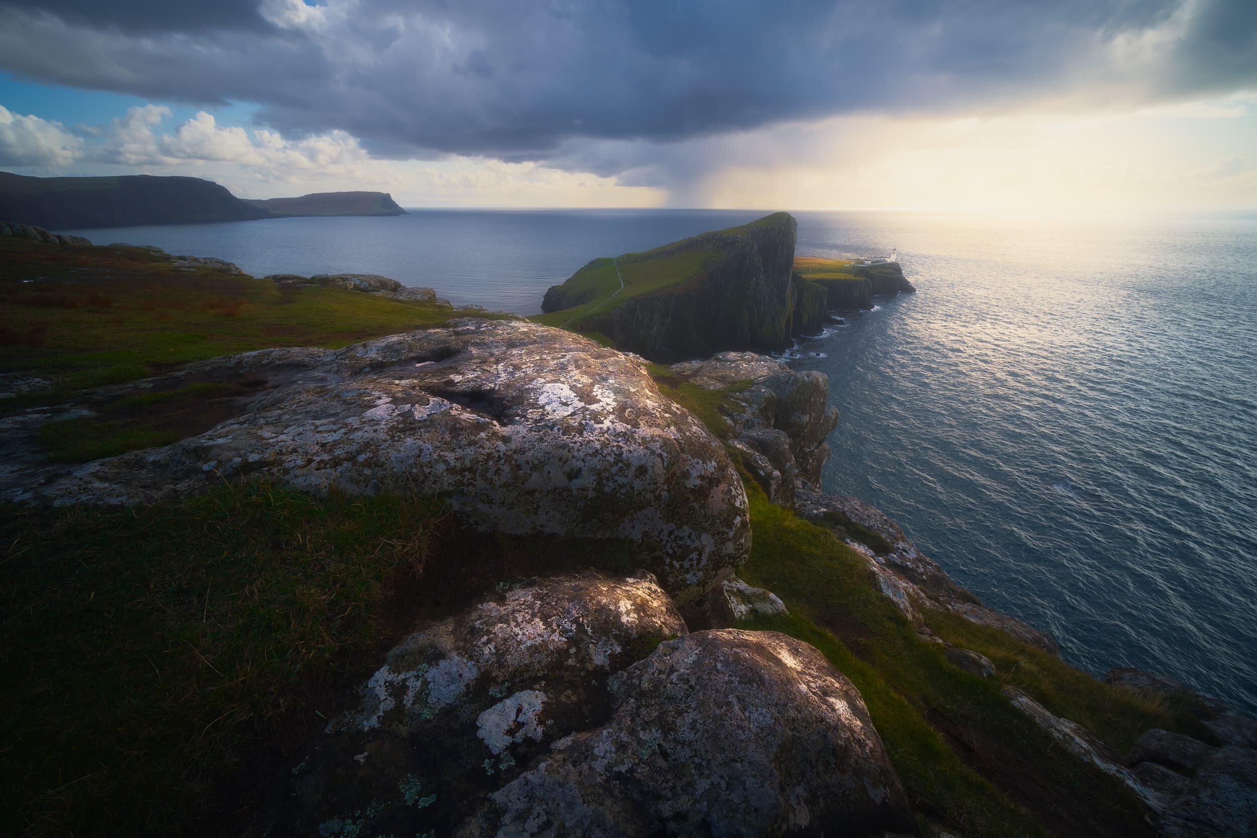
Neist Point
We managed a brief visit to Neist Point during a day spent running away from various wet weather systems. The area is known for its views towards the Neist Point cliffs and its lighthouse, but one shouldn’t ignore the vast cliffs of Waterstein Head, reaching 882 ft high.
With my 9mm ultra-wide Laowa lens I was able to capture this vast panoramic view of Neist Point, its lighthouse, as well as the Ramasaig cliffs. We watched as a weather system approached us from across the sea, absolutely heaving it down into the waters.
Another ultra-wide composition, shot vertically, showing Neist Point’s cliffs and lighthouse, with the storm quickly approaching us.
Bonus
One of our “bookmarks” for October 2020’s Skye holiday was the Falls of Rha. These are a pair of powerful waterfalls located near Uig, north Skye. The falls are found in a wooded glen—relatively rare on Skye—and are almost disappointingly easy to get to. Nevertheless, they are an impressive site.
As we left the Isle of Skye on the final day we hopped back onto mainland Scotland and took a small detour to capture this incredible view. These are the Five Sisters of Kintail, a 5-mile long pointy mountain ridge. They are Sgùrr na Ciste Duibhe (1,027 m/3,369 ft, meaning “Peak of the Black Chest/Coffin”), Sgùrr na Càrnach (1,002 m/3,287 ft, meaning “Peak of the Stony Place”), Sgùrr Fhuaran (1,067 m/3,501 ft, meaning “Peak of wells/fountains”), Sgùrr nan Saighead (929m/3,048 ft), and Sgurr na Moraich (875 m/2,873 ft).

Armadale, Sleat Peninsula, Isle of Skye, Scotland
Even though we’ve been to Skye a few times now, we’d never actually explored the Sleat peninsula of southern Skye until recently.
Even though we’ve been to Skye a few times now, we’d never actually explored the Sleat peninsula of southern Skye until recently.
See more beautiful photos of the Isle of Skye, Scotland.
Sleat is rather unlike the rest of Skye. Whereas most of Skye is mountainous, rugged, lined with cliffs, punctuated with moorland, Sleat is more about rolling hills and pastoral land. It also offers wonderful views across the Sound of Sleat towards the Knoydart mountains.
As well as checking out the peninsula’s coastline and views, we also explored the ruins of Armadale Castle and its grounds. It wasn’t the best day in terms of light and weather, but the scenery doesn’t really need it.
Photos taken on a Fujifilm X-T2 with a Samyang 12mm f/2 NCS.