
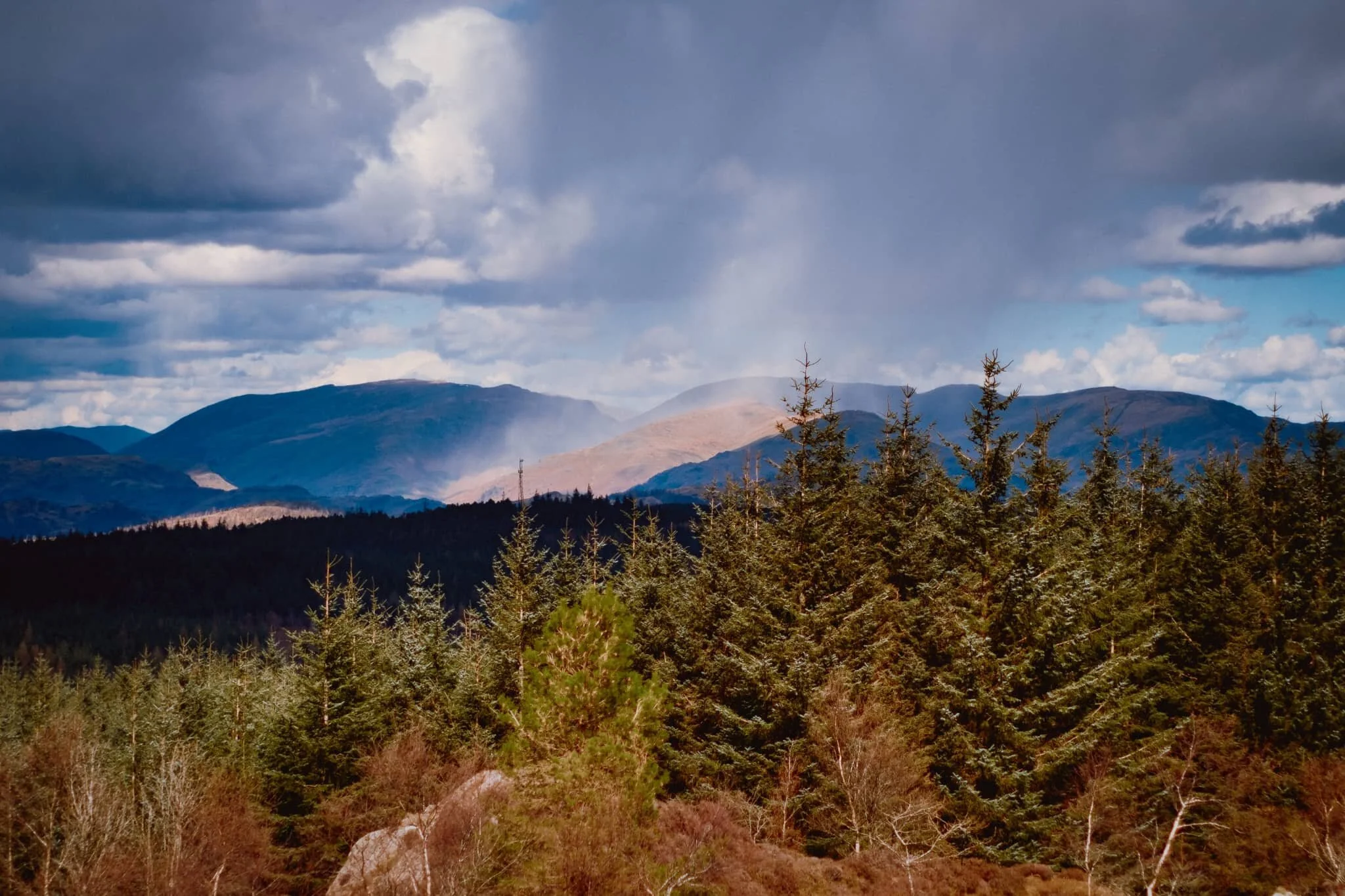
Reston Scar, Lake District, Winter
After the recent freeze, winter fog has descended over the land.
After the recent freeze, winter fog has descended over the land.
It’s been soupy thick and still, gently drenching everything and chilling bodies down to the bone.
Over the weekend, the outdoors called us—as always—and so we tried somewhere a little different. Above the village of Staveley, which also serves as the entrance to Kentmere, a small yet imposing fell dominates the skyline: Reston Scar. It may only be 834 feet (254 m) in height, but it’s relative isolation allows for cracking views…
If you could see them past the fog.
Still, it made for wonderfully moody and wintery photos.
All photos taken on my Fujifilm X-T2 using my Vivitar “Series 1” 28–105mm f2.8–3.8 zoom lens. RAWs converted in Capture One for iPad, processed in RNI Films’ Kodak Portra 400 profile, finalised in Affinity Photo 2 for iPad.
Reston Scar, Lake District, Winter by Ian Cylkowski is licensed under CC BY-NC-SA 4.0![]()
![]()
![]()
![]()
The southern aspect of Reston Scar drops steeply down to the village of Staveley, allowing for—potentially—extensive views.
Near the summit lies Kemp Tarn. I don’t know if it’s any good for wild/outdoor swimming, but on this day it was completely frozen over. I’d have got closer to its shore but the surrounding land was boggy, even in these temperatures.
The edge of Reston Scar, looking over to Craggy Wood/Piked Howe, before it drops right down to Staveley village.
I enjoyed the intersecting lines of the stone wall and the fell slopes.
The summit cairn of Reston Scar, with the merest hint of Ings village below.
In better light, I’d like come back to Reston Scar and explore more of these craggy formations I found. I’m sure there’s some rad compositions to be had.
For now, these will have to do.
Did you enjoy these photos?

Orrest Head, Lake District, Winter
Arctic conditions have returned.
Arctic conditions have returned.
After what’s seemed like an endless amount of rain, a dry and cold front has arrived over the British Isles, covering the fells in frost and snow.
Before family obligations in the afternoon, Lisabet and I got up early (for a Sunday morning) for a quick hike up the classic Orrest Head. It’s a quick way to get a good vantage point and drink in the views of all the snowy fells.
Thankfully, the light was also lovely.
All photos taken on my Fujifilm X-T2 using my Vivitar “Series 1” 28–105mm f2.8–3.8 zoom lens. Shot with the Eterna film simulation, RAWs developed in Capture One for iPad, finalised in Affinity Photo 2 for iPad.
Orrest Head, Lake District, Winter by Ian Cylkowski is licensed under CC BY-NC-SA 4.0![]()
![]()
![]()
![]()
From the parking bay off the main A591, we can immediately see the Coniston fells in their wintery glory rising above Windermere.
I’ve said it many times before, but snow makes the fells seem even taller.
Elleray Woods underneath Orrest Head shelter you from the biting winds whipping the fells. Plenty of rhododendron about with their evergreen leaves.
My favourite in Elleray Woods. It’s like the roots are slowly dripping down and covering the crags.
Low winter morning light catches the gentle curves of Sour Howes, with the higher peak of Yoke glowing in its winter coat.
The snowy fells rise above Threshthwaite Mouth, part of the Kentmere fells.
With light as fleeting as it is in the winter, you have to keep your eyes open for quick moments and smaller scenes like this.
And there, the famous view from the summit of Orrest Head, the view that Alfred Wainwright fell in love.
The summit of Orrest Head features these wonderful rock formations, and the low winter light really pulled out all the textures.
Not a bad place for a bench and a view, eh?
Light scans across the fields towards the frosty maw of Threshthwaite Mouth.
Zooming in on Threshthwaite Mouth as slivers of golden winter light sweep across the rolling fields below.
One or two people similarly made their way up onto Orrest Head and enjoyed the views and conditions on offer.
On our way back down from the summit, the day brightens up and the light evens out a little. A little hint of 2022’s autumn colours linger on.
Always nice to see the Gruffalo on the winding track back down to the car.
Did you enjoy these photos?

Llyn y Fan Fach, Brecon Beacons, South Wales, Autumn
If I had one main personal goal for this fortnight in South Wales we’re enjoying, it’s to get up one of the mountain ranges in the Brecon Beacons National Park.
If I had one main personal goal for this fortnight in South Wales we’re enjoying, it’s to get up one of the mountain ranges in the Brecon Beacons National Park.
There’s a few mountain/hill ranges in the Brecon Beacons National Park, the main two I was interested was either:
The Brecon Beacons, at the heart of the national park, which includes South Wales’ highest peak Pen y Fan (886 metres/2,907 feet)
The Black Mountain, sometimes known as the Carmarthenshire Fans.
On this occasion, we elected to hike up the Black Mountain range above the mountain tarn known as Llyn y Fan Fach.
The day promised to be glorious, with puffy white clouds and strong sun in the crisp autumn air. Though we were disappointed at the sight of Llyn y Fan Fach halfway up the climb (it seems to be in the process of being emptied), the views on the way up to the peaks were absolutely astounding.
All photos taken on my Fujifilm X-T2 using my Vivitar “Series 1” 28–105mm f2.8–3.8 zoom and Laowa 9mm f2.8 prime lenses. RAWs converted in Capture One for iPad, developed and finished in Affinity Photo for iPad.
Llyn y Fan Fach, Brecon Beacons, South Wales, Autumn by Ian Cylkowski is licensed under CC BY-NC-SA 4.0![]()
![]()
![]()
![]()
After exiting a busy car park we started the ascent up the Beacons Way path direct towards the tarn. Looking to the east I nabbed this quick shot of the criss-crossing hills towards Bryn Blaen-Wysg.
About halfway up the path is a small hut where the dam is. Above it are these fish hatcheries which were originally used as filter beds. The rounded hills at the bottom of the path are in stark contrast to the shapes of the Black Mountain, as you’ll see.
As we climb the views get ever more extensive. The last time we visited Llyn y Fan Fach, back in October 2018, there were few people around. This time the car park was full and cars had been dumped on the grass verges along the road leading to the car park. Apparently this area became vastly more popular after being featured in a 2020 TV series “Secrets of Britain”.
From the left, Fan Brycheiniog and Picws Du come into view, with their heavily glaciated and steep northern craggy faces. Morning sun was attempting to break through the clouds above.
Wow, am I right? After seeing the state of Llyn y Fan Fach, we quickly continued our ascent up the Black Mountain. The views looking back to the peaks were too incredible to ignore. The tallest peak, Fan Brycheiniog, is on the left, or strictly speaking its “nose”, Fan Foel. This is followed by Picws Du, Cefn Twrch, and Waun Lefrith.
The hike up the western slopes of the Black Mountain is steep, and the drop down to the tarn is sheer… but I mean, look at those views. The light got more intense, too, as the clouds started to dissipate and reveal the sun.
These peaks are primarily composed of Old Red Sandstone, laid down around 400 million years ago, with bands of Carboniferous Limestone. I wanted to find some of the exposed red sandstone as a contrast to all the grass.
More cracks of ruby red sandstone which I wanted to emphasise with a vertical composition towards the Black Mountain peaks.
My lovely Lisabet, being immensely more brave than I as she stands atop an exposed crag with a 500ft sheer drop beneath her.
This was about as close as I dared go to those crags, with the beautifully curved glaciated wall of Waun Lefrith in the distance.
Did you like these photos?
Grizedale Forest, Lake District, Spring
Welcome to Grizedale Forest.
Welcome to Grizedale Forest.
After a morning of joint optician appointments, the day was looking fine and ripe for some hiking. Where would we go? Lisabet suggested Grizedale Forest, which I immediately leapt on. She’s never been to the area, and the last I visited was so long ago that I cannot summon any memories of the place.
Grizedale Forest can be found south of the famous Lakeland village of Hawkshead, in between the lakes of Windermere and Coniston Water. If you’re curious about the name it originates from Old Norse, the language of the Vikings. “Grize” comes the Old Norse gris, meaning a “boar” or “pig”, and “dale”—from the Old Norse dalr—means “valley”, giving us “valley of the pigs”. The area stretches over 24 km² and features a number of trails for walkers and cyclists, small tarns and fells, and a fully-featured visitor centre.
We parked some distance away at Moor Top, hiked into Grizedale village, and hopped onto the Carron Crag Trail, with the aim of reaching the summit of Carron Crag at 314 m (1,030 ft).
The hike vastly exceeded our expectations and the views from the summit of Carron Crag were outstanding. The Coniston fells looked incredible and we could even make out a highly localised hailstorm falling over Seat Sandal!
Another crackin’ day.
All photos taken on my Fujifilm X-T2 using my three prime lenses: a Samyang 35mm f/1.2, a Laowa 9mm f/2.8, and an adapted Pentax SMC 55mm f/2.0. Developed using RNI’s Kodachrome film profiles.
The way down to Grizedale village.
On the trail we quickly gain height via the clearly-marked finger posts. Lisabet’s eagle eye spots some interesting minute details and goes in for some snaps.
Some of the trees near Carron Crag were covered in thick sheets of moss, which I couldn’t resist making some photos of.
Wonderful shapes and textures of all the trees and their branches absolutely coated in moss.
A side trail heading deep into the dark forest…
Just one of the many incredible views from the summit of Carron Crag! We could see a highly localised hailstorm drenching Seat Sandal above Grasmere.
The Old Man of Coniston (802 m/2,632 ft) from the summit of Carron Crag, clear as a bell.
More of the Coniston fells, catching some dappled light through the increasing cloud cover.
A wider panorama of the Coniston fells from Carron Crag, with the Old Man on the left.
Coming down the other side of the summit, Lisabet finds one of many sculptures dotted about the forest.
The way back down into the woods, with the Kentmere fells clearly visible.
There’s something unique and magical about woodland light.
Some interesting contraptions that mountain bikers can investigate on their woodland trails.
A gentle Ent, standing guard at the entrance of the Milwood Trail.

Latrigg, Lake District, Winter
It’s really starting to feel like winter in the Lake District now.
It’s really starting to feel like winter in the Lake District now.
As the weather improved over the Christmas Break, Lisabet and I decided to embark on a hike up a fell we’ve never done before: Latrigg.
Latrigg is a rather unassuming fell, measuring only 368 m/1,207 ft high. But what it lacks in height or stature it more than makes up for with the views it has to offer.
Technically Latrigg is part of the main Skiddaw massif, the mountain range that looms above Keswick town, disconnected by a depression that drops to 900+ ft. For those with limited mobility it’s possible to reach the summit of Latrigg via a car park near the peak. We decided instead to start in Keswick and hike up the Cumbria Way to the summit.
We certainly weren’t alone and we could easily see why. The day was ice-cold and clear, with gorgeous low winter light filtering through an atmosphere of ice crystals, resulting in shows of 22° halos around the sun and mist lingering around the fells. Skiddaw, Blencathra, and the Derwentwater fells also had plenty of snow on their peaks, adding to the sense of awe.
I hope these photos convey the beauty we experienced on this hike.
All photos shot on my Fujifilm X-T2 using both my Samyang 35mm f/1.2 and Laowa 9mm f/2.8 lenses. A variety of Fuji’s film profiles were utilised in the RAW developing.
As we ascended up the steep section of the Cumbria Way, the views looking back west and southwest grew more impossible to resist photographing. The sun was too weak to burn away the morning’s temperature inversion, leaving floating tufts of mist to meander around the fells.
As we broke off the Cumbria Way to take the path up towards the Latrigg summit, and patch of mist floated our way and obscured views back towards Skiddaw (931 m/3,054 ft). I quickly nabbed this 35mm composition of what turned out to be a fleeting moment.
We joined, at a distance, other groups of people near the summit of Latrigg, admiring the views and the incredible light show. The halo around the sun is known as a 22° Halo, caused by sunlight refracting through millions of hexagonal ice crystals in the atmosphere. The lake in the distance is Derwentwater.
From the summit of Latrigg, looking back towards the Derwentwater and Whinlatter fells as another patch of mist slowly creeps up the shoulders of the fell.
Plenty of dogs were enjoying the sights and smells of the fell too.
Away from the sun we continued on the summit track back down Latrigg’s eastern shoulder, affording us wonderful views of a snow-clad Blencathra (868 m/2,848 ft). More mist streamed in to partially obscure the views of the mighty fell.
Following, at a distance, other hikers back down the Cumbria Way, with extraordinary views towards the Whinlatter and Lorton fells.

Loughrigg, Lake District, Autumn
There are several Wainwrights that are considered key or “core” Wainwrights.
There are several Wainwrights—that is, Lake District peaks written about in Alfred Wainwright's seven-volume Pictorial Guide to the Lakeland Fells—that are considered key or “core” Wainwrights.
They include the likes of Catbells, Helvellyn, Scafell Pike, and the Old Man of Coniston.
You could also argue that Loughrigg Fell should be included as a core Wainwright, too. And in all my years of living in Cumbria I’ve never once been up this relatively small yet sprawling fell.
So, at 5:00am this morning, we changed that.
Loughrigg Fell, or just Loughrigg, is one of the smaller Lake District fells, measuring only 335 m or 1,099 ft (compare this to England’s highest peak, Scafell Pike, coming in at 978 m/3,209 ft). However, its mass covers a surprisingly large area near Central Lakeland. To its north are two lakes: Grasmere and Rydal Water. To its west the fell overlooks Loughrigg Tarn followed by Elter Water. East, the River Rothay runs through a shallow depression, and south of Loughrigg is England’s largest lake: Windermere.
Because the fell covers such a large area there are many ways to access its numerous crags and the summit. We arrived at a lay-by near the shore of Grasmere and set off for the fell at around 6:45am. We took the route through Penny Wood onto Grasmere “beach” and then up into Deerbolts Wood, before joining Red Bank and taking the steep pitched path up onto Loughrigg’s various nobbly crags.
The morning was clear and glorious, and we watched as the rising sun slowly lit up the various peaks you can make out from around the shoulders of Loughrigg, such as Wetherlam and the Langdale Pikes. By the time we hit the summit the sun had risen and was covering the rolling crags of Loughrigg in golden light.
What a cracking morning.
All photos shot on a Fujifilm X-T2 with a XF 18–55mm f/2.8–4.0 lens using a customised Classic Chrome film profile.
Looking back down the steep pitched path that was our route up to the summit of Loughrigg. Silver How (395 m/1,296 ft) starts catching the soft pre-sunrise light.
Loughrigg features lots of lovely crags from which you can take your pick of compositions towards the distant fells. Here I pointed the camera towards the Langdale Pikes as they started to glow.
I find another or Loughrigg’s crags, surrounded by autumnal fern, which I use to point towards Wetherlam as it glows pink.
Higher up we can better make out the Langdale Pikes and Crinkle Crags (859 m/2,818 ft) as more of the land is bathed in warm sunrise light.
Another crag offers a framing and leading device for a composition towards Dunmail Raise, north of Grasmere village.
My lovely Lisabet takes a pew on some crag and enjoys the views as more of the fells light up in the sunrise glow.
A beautiful Herdwick yow (ewe) stares at us curiously with its smiling face. Behind her are the glowing slopes of Lingmoor Fell (469 m/1,539 ft).
The Rydal Fells, which ultimately lead up to Fairfield (873 m/2,864 ft).
Looking up the undulating folds towards the summit of Loughrigg, marked by a trigpoint.
I wanted to capture the criss-crossing and layering of the land as the sun rose over the fells.
Looking back at the route up to the summit of Loughrigg. In the distance is Grasmere village and the fells north of it: Helm Crag, Steel Fell, and Seat Sandal.
From the summit of Loughrigg you can finally make out some of Windermere lake.
From the summit you can enjoy a clear view of Wetherlam (763 m/2,502 ft), which I shot from the summit’s crags.
Probably my favourite photo from the whole hike.
Another ewe enjoys the views from one of Loughrigg’s crags.
The rolling craggy landscape of Loughrigg as the walking trails meander towards Windermere.
Lisabet inches closer for a better snap of the ewe and her lamb.
Incredible views from Loughrigg towards Elter Water and Wetherlam above.
Up in the Lakeland Fells autumn has arrived as the fern on the fell slopes turn a beautiful rusty colour.
A lone Herdwick ewe munches on the bracken in a steep gully below the rolling crags of Loughrigg.
Near Loughrigg’s northeastern slopes you can find increasing evidence of quarrying. Here we found a deposit of slate, forming a little mound of its own.
Tracking the outcrops of rhyolite and basaltic andesite towards the Scandale fells.
Lisabet pauses to enjoy the views as we navigate our way down the slopes of Loughrigg.
Back onto the main path that circumnavigates Loughrigg, known as the Loughrigg Terraces, we find Rydal Cave. This is a man-made cave; created as consequence of quarrying slate for roofing material.
A pool has filled Rydal Cave, offering crisp reflections that I played around with.
We spotted teeny little fishes in the pool too! Couldn’t say what they were, though.
Back on the main path around Loughrigg and looking up at Ewe Crag.
Into the woods alongside the River Rothay we chanced upon a couple of Herons. One of them flew off almost immediately but this one, hunched up, stayed on its perch long enough for me to get this quick snap.
In Penny Wood we notice that Grasmere is offering some crisp reflections of Silver How, which clamber down to get shots of.
All in all a 10/10 morning.