
Brigsteer Park, Lake District, Spring
I wanted to see a lot of bluebells one last time for this year.
I wanted to see a lot of bluebells one last time for this year.
A work colleague tipped me off about Brigsteer Park, a woodland south of its village namesake, Brigsteer. The village sits underneath Scout Scar, and there’s a surprising amount of woodland underneath this fell.
So, Lisabet and I parked up at Helsington St. John’s Church and plotted a route down the fell slope, through a Bee Reserve and into Brigsteer Park for a ruddy good exploration.
All photos taken on my Fujifilm X-T2 using two of my prime lenses: a Fujinon 23mm f/2.0 and an adapted Pentax SMC 55mm f/2.0. Images developed using RNI Films’ Kodachrome film profiles.
The views from the car park Helsington St. John’s church are sublime. All the way across the Lyth Valley to the Lake District fells.
The southern shoulder of Scout Scar and the small road that allows access to Helsington St. John’s Church.
As we navigate the footpaths down the fell slope, Whitbarrow commands your attention directly across the Lyth Valley.
Couldn’t resist a shot of this gorgeous old house, covered in ivy.
A delightful little cottage on Park End Lane just before you enter Brigsteer Park.
Whoever lives at the cottage is a keen gardener. We had to look up what these weird and wonderful plants were. Turns out they’re probably Chilean Rhubarb, Gunnera tinctoria. Also, not actually related rhubarb though you can apparently consume Chilean Rhubarb as you would normal rhubarb.
Looking back at this impossibly idyllic scene before we head into the woods.
It turns out that Brigsteer Park is a proper woodland, thick with growth and full of old trees.
An old tree with its own “cane”.
Look at this old yew tree with its “ligaments” and textures. Isn’t it magnificent?
Another old yew, found further into the woodland.
As we neared the exit, I turned back to snap this scene. Unfortunately, I didn’t see any sign of carpets of woodland here at Brigsteer Park. Perhaps we were in the wrong bit?
Whitbarrow Scar once again commanding our attention from across the Lyth Valley.
After carefully navigating through some young cows and bullocks, we returned to Park End Lane. The gardener’s cottage here, cosily nestled in the woods of Brigsteer.
Everywhere is exploding in colour and wildflowers.
Brigsteer Causeway, which cross the wetter and more swamp-like part of the Lyth Valley.
Brigsteer is such a bonny village.
I mean, come on.
Not a bad place to do the rounds.
As we started climbing the road up back towards St. John’s Church, the views opened to us again. Here you can see right across the Lyth Valley and even the Kent Estuary towards Arnside Knott.
Not a bad way to spend the morning.
Did you like these photos?
Then support me.
Pandemic Peregrinations: Whitbarrow, Cumbria, Spring
I’ve often gazed longingly at Whitbarrow Scar from afar.
I’ve often gazed longingly at Whitbarrow Scar from afar.
Finally we decided to clamber around it.
Whitbarrow (215m/705ft) is a limestone hill, much like its neighbour Scout Scar, with whom I’m much more familiar with. Whitbarrow is further west of Scout Scar across the Lyth Valley, but covers a much larger area. When viewed from the A590 south of the fell, Whitbarrow presents some sheer and imposing cliff faces that I instantly fell in love the first time I saw them. I resolved to one day wander around the contours of Whitbarrow. Today was that day.
Whitbarrow is definitely not as easy to access as Scout Scar. Whereas Scout Scar can be reached with ease from the tiny car park near its northern edge (or walked to directly from Kendal), Whitbarrow has no official car park nearby and is surrounded only by tiny villages and hamlets. We elected to park in one of the laybys off the A5074, then walk into the village of The Row to find the footpaths up onto Whitbarrow.
We spent a good 2-3 hours around Whitbarrow and quickly got the distinct impression that this was a fell that we could return to time and time again, and still not see all of that. The fell is quite vast and varied. Its western flank drops down steeply to the valley floor at Whitbarrow Scar, but does so more smoothly compared to Scout Scar’s vertical cliffs. The eastern part of Whitbarrow is a protected Nature Reserve, featuring limestone shelves, limestone pavements full of clints and grikes, and lots of woodland.
We managed to summit the fell at Lord’s Seat and made a small loop back towards The Row. There is still a lot to more explore of Whitbarrow, and I look forward to returning again.
All photos shot on my Fujifilm X-T2 using my three prime lenses: a Samyang 35mm f/1.2, a Laowa 9mm f/2.8, and a converted Pentax SMC 55mm f/2.0. Developed using RNI’s Kodachrome film profiles.
As we started to ascend out of The Row, the views across the Lyth Valley towards the Far Eastern Lake District fells quickly opened up. We were blessed with another lovely day of weather.
There is considerably more woodland on and around Whitbarrow compared to Scout Scar.
From the woodland near The Row known as the Township Plantation, we branched off west towards the cliffs of Whitbarrow Scar. We wanted to see what the views towards the Lake District fells were like.
The way forward, with some runners up ahead. The sky was a lot more dramatic today, but still thankfully dry.
Now that’s a view. The Langdale Pikes towards the right, Wetherlam and the Coniston fells towards the left. Dappled light everywhere. Glorious scenes.
The cliffs north of Whitbarrow Scar with the Eastern Lake District fells in the distance.
Just amazing views of the Kentmere and Longsleddale fells.
Near Bell Rake the land drops away sharply, exposing these silver birch to the consistent westerly winds.
One of many glacial erratics around Whitbarrow, physical testament to the fell’s ice age history.
After summiting at Lord’s Seat we followed the “spine” south from the summit, taking in the views towards Morecambe Bay along the way.
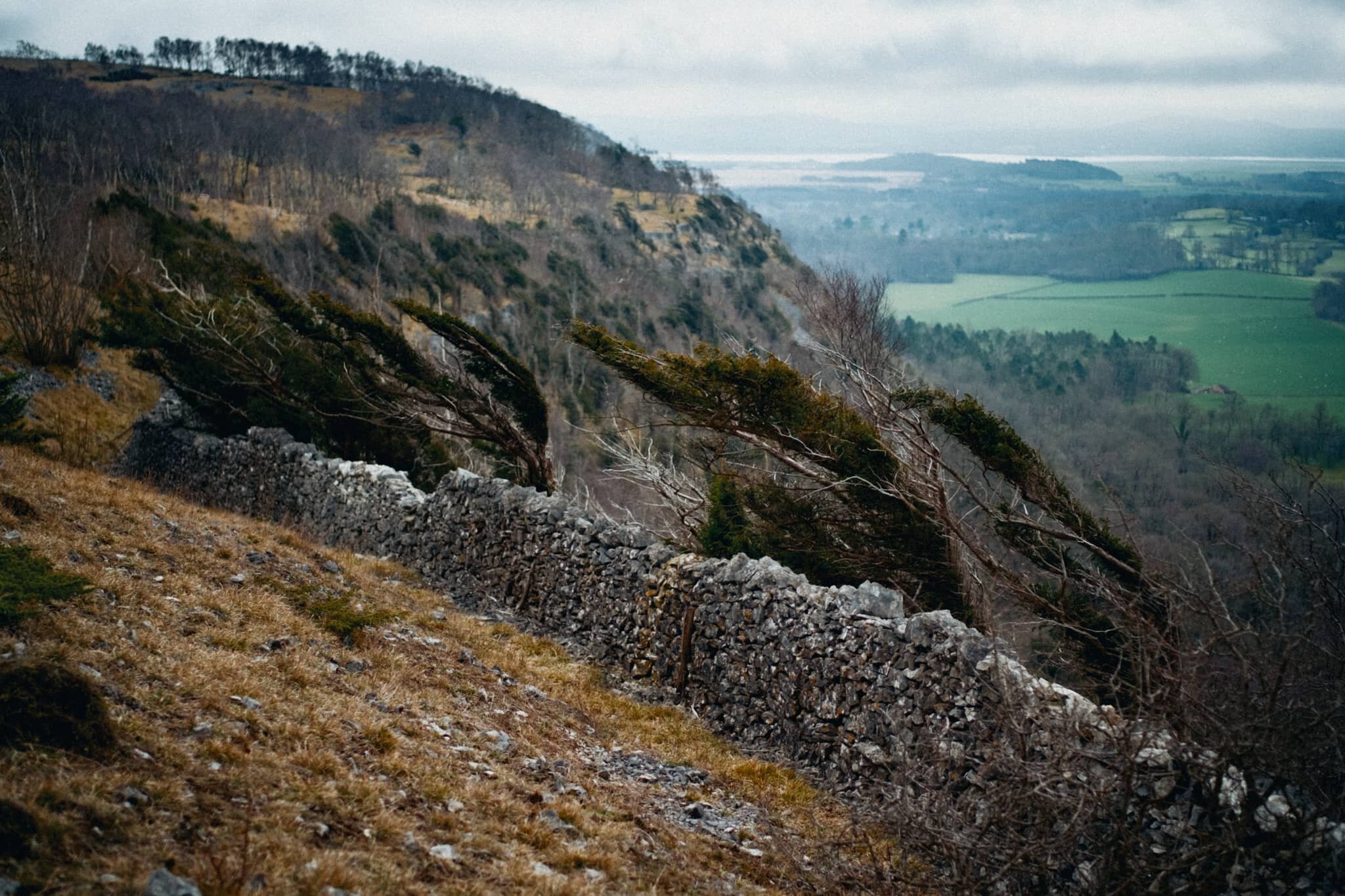
Getting closer to the precipitous drop of Whitbarrow Scar.
A wall prevents you from getting near the edge, lest you tumble towards the valley floor. Wind-blasted trees give an indication of what the conditions can be like on the fell.
More wind-blasted silver birch with moody skies.
Just one example of the almost impossibly perfect wall-like structure of the limestone pavements found near the Whitbarrow Nature Reserve.
Whitbarrow Nature Reserve is a limestone woodland, featuring all manner of flora that survives in the acidic soil conditions and changeable weather.
My ultra-wide 9mm lens had some fun following various tree trunks and branches for more unusual compositions.
We found this weird tree that appeared to have a separate tentacle-like trunk growing out of it. I got close and low with my 9mm lens to follow the line of this trunk.
A rather unusual tree, to my experience; the trunk is almost tendon-like in its structure. Google thinks this is Hesperocyparis macrocarpa, a Monterey cypress tree.
The way back to The Row through the Township Plantation. We’ll be back, Whitbarrow…