
Kirkby Lonsdale, Cumbria, Summer
In most seasons, Kirkby Lonsdale is lovely.
In most seasons, Kirkby Lonsdale is lovely.
But during summer, it’s impossibly pretty.
The last couple of weeks my focus has primarily been helping the Better Half recuperate after double Carpal Tunnel Relief surgery, hence the lack of content on this website. But, with the removal of stitches on the horizon, a gorgeous weekend was looking promising, so we made our way to beautiful Kirkby Lonsdale for a gentle walk around the town and its environs.
It’s hard to take a bad photo of Kirkby.
All photos taken on my Sony α7ii, using my Sony 24-240mm F3.5-6.3 OSS zoom and Rokinon 14mm f2.8 ED AS IF UMC prime lenses. RAWs developed in Lightroom, edited in Photomatix, and finalised in Photoshop.
Kirkby Lonsdale, Cumbria, Summer by Ian Cylkowski is licensed under CC BY-NC-SA 4.0![]()
![]()
![]()
![]()
One of the more iconic views of Kirkby Lonsdale, shot from near the top of Mitchelgate. Some of these cottages have been standing here since the late 17th century. Interestingly too, large parts of Mitchelgate in the early and mid-1900s were considered slums, and there was talk of taking some of these buildings down.
On the right, the Sun Inn, which has been around since the 1600s at the intersection of Market Street and Church Street. It retains a lot of its original features such as the overhanging first floor support by these huge limestone pillars.
This little area down Red Dragon Yard and Mill Brow is known as Swine Market because, historically, that’s what this area was. The pillar structure is the Old Market Cross, formerly located at the junction of Main Street, Market Street, and Mill Brow. It was relocated to Swine Market in 1822. The steps and crowning ball were a later addition.
Opposite Swine Market is a small road known as Horse Market because, again, historically this is what it was. Some of the houses down here still have horse insignia on plaques above their doors; again, some of these houses have been around since the late 1700s.
Tucked away from Mill Brow, Red Dragon Yard, and Horse Market is this gorgeous old property. I can’t find mention of it anywhere on the world wide web. The stone panels on the first floor have intricate masonry decorations too. I wonder what the history of this property is.
Looking down Mill Brow as it steepens, another wonderful view opens up towards Gragareth (627 m / 2,057 ft). Historically this fell formed the boundary between the West Riding of Yorkshire and Westmorland; there’s still a drystone wall up there that follows the old county boundary.
Another classic Kirkby Lonsdale view: Old Manor House on Mill Brow, with the Leck and Barbondale fells in the distance. And of course, during the summer, the House’s gardens burst into colour.
Old Manor House dates from around 1700, probably incorporating parts of an older structure.
Around Devil’s Bridge, cows were chilling and gently grazing on the full pastures around the river. A proper bucolic scene I wanted to capture.
Kirkby’s famous Devil’s Bridge, dating from around the 12th or 13th centuries. For centuries this was one of the few bridges for miles that crossed the River Lune. Nowadays modern traffic is diverted over Stanley Bridge from where this photo was shot. On a hot summer’s day you’ll always find people milling about the bridge, jumping into the river (even though they shouldn’t) and genuinely enjoying the natural delights around here.
From Devil’s Bridge, people swim and play in the river, and picnic on the rocks. What better way to enjoy a gorgeous summer’s day?
Stanley Bridge from Devil’s Bridge. Stanley Bridge is now what carries motor traffic over the Lune.
We took the riverside path along the Lune. Near the island, where the Lune temporarily splits in two, we stopped and hushed as we spotted a Grey Heron across the river. It was carefully watching the water, so I happily zoomed in tight and made a few compositions of this magnificent bird.
Further along the Lune and set back from the river, Lunefield Farmhouse demands your attention. A 19th century stone-built former coach house, it’s now been restored as holiday accommodation for up to 8 people.
At the end of the riverside path before heading up the Radical Steps, glassy reflections in the Lune make me stop and nab a composition of this trio of trees.
Up and beyond the Radical Steps, I equip my 14mm ultra-wide lens and frame this composition of St. Mary’s Church using the old gateway. Parts of the church date from Norman times.
Near where we parked our car, just outside of town, is Underley Lodge, a former gatehouse to the Underley Estate, now private tenanted accommodation.
Did you enjoy these photos?

Conistone, Yorkshire Dales, Summer
Time for somewhere new.
Time for somewhere new.
The weekend was looking massively busy in Cumbria, what with the Appleby Horse Fair, Dave Day, and the Great North Swim, amongst other things. So with a cool and windy Saturday in stall, we head east once again into the Yorkshire Dales to explore somewhere new, to us: Conistone.
Conistone is a tiny idyllic village in Upper Wharfedale, across the valley from Kilnsey and its famous Kilnsey Crag. Although we’ve meandered around Grassington and Kilnsey before, we’d never ventured around the Conistone area of Upper Wharfedale. What we found were two incredible and fascinating geological wonders: Conistone Dib—a dry and steep gorge—and the Conistone Pie, an isolated limestone crag outcrop that, yes, resembles a pie.
Due to the high winds, conditions and light were changeable, which made shooting all the more challenging and fun.
And some of the views we got from around the pie were just… something else.
All photos taken on my Sony α7ii using my Sony 24-240mm F3.5-6.3 OSS zoom and Rokinon 14mm f2.8 ED AS IF UMC prime lenses. RAWs were developed in Lightroom, edited in Photomatix, and finalised in Photoshop.
Conistone, Yorkshire Dales, Summer by Ian Cylkowski is licensed under CC BY-NC-SA 4.0![]()
![]()
![]()
![]()
The centre of Conistone village, looking impossibly idyllic. A few homes here had datestones from the mid-17th century.
Heading immediately east out of the village, a footpath can be picked up that takes you up the first part of Conistone Dib, known as Gurling Trough. Delicate flowers pepper the grasses around the trail. Our excitement builds.
Thousands of years after retreating glaciers and meltwaters have finished their work, life clings on in this gorge in beautiful ways.
The gorge winds its way uphill, in increasingly tight channels. Now we’re in summer, foliage and wildflowers adorn every possible nook and cranny. Up ahead, Lisabet gawps at the stunning walls of the gorge.
The only way up and out of the gorge, a tiny person-wide chute, evidence of where prehistoric water would’ve raged through this gorge.
Looking back down the chute, I picture in my mind how gallons of water would’ve created enormous forces as it was squeezed through this tiny gap.
After popping out from the squeeze at Gurling Trough, you are presented with this glorious view of the dry valley of Conistone Dib. To the right is the imposing crag of Bull Scar.
Further up the valley our next squeeze presents itself. A characteristic drystone wall acts as a leading line all the way towards the next gorge.
Halfway up the dry gorge of Conistone Dib. An old drystone wall leads the way up, as does the ankle-breaking loose limestone scree.
Near the top, Lisabet stops to photo some flora that her eagle-eye spotted. Two trees act as a kind of “gateway”, marking and maybe even guarding the exit.
We scramble our way up and out of the gorge, but not before I turn back around and nab this composition from behind one of the “guardians”, using them to frame the gorge back downstream.
From the top of the Dib, looking perilously down to the gate and the dry gorge below that we scrambled up.
From above the Dib, multiple trails criss-cross each other towards a multitude of destinations. We took a small diversion around the top of the gorge, and found this stunning composition of Conistone Dib gorge, with the Upper Wharfedale fells beyond.
Our next destination was to find the Conistone Pie. From the Dib, it didn’t take long to locate and follow the path northeast. We soon clambered towards the Pie, and I immediately scouted around its circumference, snapping compositions of its wonderful limestone crags with views towards the far reaches of Upper Wharfedale.
The views from the top of Conistone Pie! Not bad, eh?
My 24-240 mm zoom lens allowed me to really zoom in tight and crop in on these more intimate landscapes my eye can spot.
Another long zoom composition, showing the characteristic upland fell farming landscape of the Yorkshire Dales; land parcelled off with drystone walls. I waited as slivers of golden light scanned across the landscape, and picked my moment when the foreground barn was illuminated.
From the top of the Pie you can even make out, across the valley, the impressive sheer face of Kilnsey Crag, a famous and challenging climb.
At the full 240 mm zoom, I pick out the farthest reaches of Upper Wharfedale as golden evening light scans across the dale.
Before descending back down towards the village, I sought a composition that “described” the Conistone Pie well. This was the best I could do. You can see why it’s called a pie!
From the pie we retraced our steps towards the top of Conistone Dib and located the main path, called Scot Gate Lane, which takes you all the way back down to the village. Along the way, lambs and their mums bleat and scamper away from us, but not before I was able to zoom in and capture this timeless scene.
Nearing the bottom of Scot Gate Lane, an unusual yet welcome and unfortunately rare cacophony of sounds surrounded us: Curlews! I had never heard so many. As they cried and whistled around us, the low evening low picked out this incredible scene of Conistone Dib and the valley floor of Upper Wharfedale.
Back at the village, the evening light drenches the old buildings in soft amber.
Did you enjoy these photos?
Ulverston, Cumbria, Winter
It’s been a while since my last post.
It’s been a while since my last post.
Apologies.
I hope every one has had a nice and/or peaceful Christmas.
Following the arctic blast at the beginning of December, the UK has been wet. Two storms washed over the British Isles—Elin and Fergus—bringing with them intense winds and lots of rain.
Being in Cumbria, we got the bulk of the rain.
Finally, on Boxing Day, clear skies and cool temperatures greeted us. We immediately donned gear and head out to the Furness Peninsula of Cumbria. It was time to hike up the Hoad above Ulverston.
It felt good to finally get out and about.
All photos taken on my Sony α7ii, using my Pentax SMC 28mm F3.5 and Pentax SMC 55mm f2.0 prime lenses, plus my Vivitar “Series 1” 70–210mm f2.8–4.0 zoom lenses. RAW images edited in Lightroom using RNI Films’ Kodachrome film profiles, finalised in Photoshop.
Ulverston, Winter, Cumbria by Ian Cylkowski is licensed under CC BY-NC-SA 4.0![]()
![]()
![]()
![]()
Locating the path from Ford Park, we followed it gently up towards the Hoad. Along the way, this group of trees presented a wonderful framing composition of the Hoad.
The trail quickly grew steeper, which also provided fantastic views. From the shoulder of Hoad Hill, the wet autumn and December are evident in the flooded fields near the coast of the Leven Estuary.
Near the top of the hill, as the trail levelled out, we could start making out the Lakeland fells above the Furness hills. The particularly rounded fell centre-right is Wetherlam (763 m/2,502 ft).
Near the monument, outcrops of Bannisdale Slate gave me a wonderful opportunity for some compositions involving the Hoad.
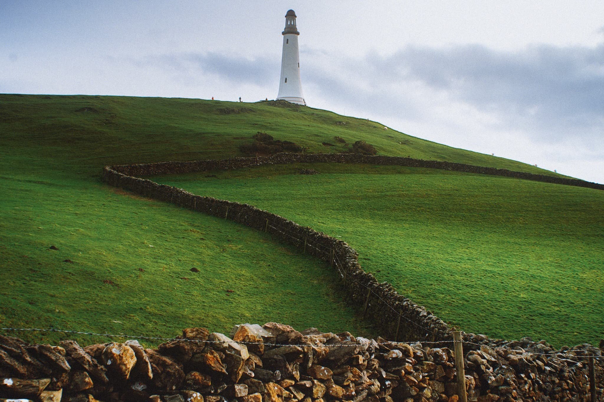
The Hoad goes by a few names. It’s officially known as the Sir John Barrow Monument, but is also known locally as “the Pepperpot”.
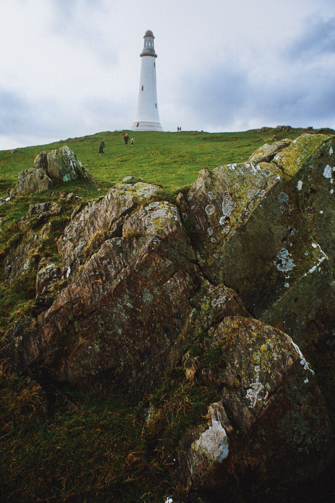
The Hoad was built in 1850 at a cost of £1,250, roughly £138,000 in today’s money. It was built to commemorate Sir John Barrow, who was a founding member of the Royal Geographical Society, and born in Ulverston. Though it looks like a lighthouse, it has never functioned as one.

The views from the Hoad are extensive and panoramic. Plenty of folk were out and about, enjoying a Boxing Day waltz and soaking in the views from the Hoad.
With my 70–210 mm equipped, I was able to pick small sections of Ulverston town. Here, looking southwest from the Hoad, the winding A590 road provides a focal point for the busy architectural landscape of Ulverston.
The view north from the Hoad couldn’t be more different. Rolling countryside, drystone walls, and sheep give way to the mighty Coniston Fells.
Northeast of Hoad Hill, another small hill provides sustenance to yet more sheep. In the distance, the Windermere fells partially obscure the Kentmere fells.
The way back to Ulverston town. You know me, I can’t resist a winding path.
A winding drystone wall catches my eye for a nice composition involving the Hoad.
Back in Ulverston, a wall mural tells the story of Sir John Barrow.
Did you enjoy these photos?
Durham, County Durham, Autumn
My first time in Durham.
My first time in Durham.
On the day of our anniversary proper, we woke up nice and early for a full day exploring the historical city of Durham.
I’d never visited the city before. Durham didn’t let me down. The day was bright and clear, bouncing golden light off Durham’s architecture, both modern and ancient.
Though our itinerary was kinda loose, a definite desire was to explore the epic Durham Cathedral, part of a UNESCO World Heritage site with Durham Castle.
Though our day was unfortunately cut short as I unexpectedly developed a stomach bug, what we did manage to see inspired to visit again.
All photos taken on my Sony α7ii using my Pentax SMC 28mm F3.5 and Rokinon 14mm f2.8 ED AS IF UMC prime lenses. RAWs were developed in Lightroom using Cobalt Image’s Sony profiles, with extra help from Photoshop and Photomatix.
Durham, County Durham, Autumn by Ian Cylkowski is licensed under CC BY-NC-SA 4.0![]()
![]()
![]()
![]()
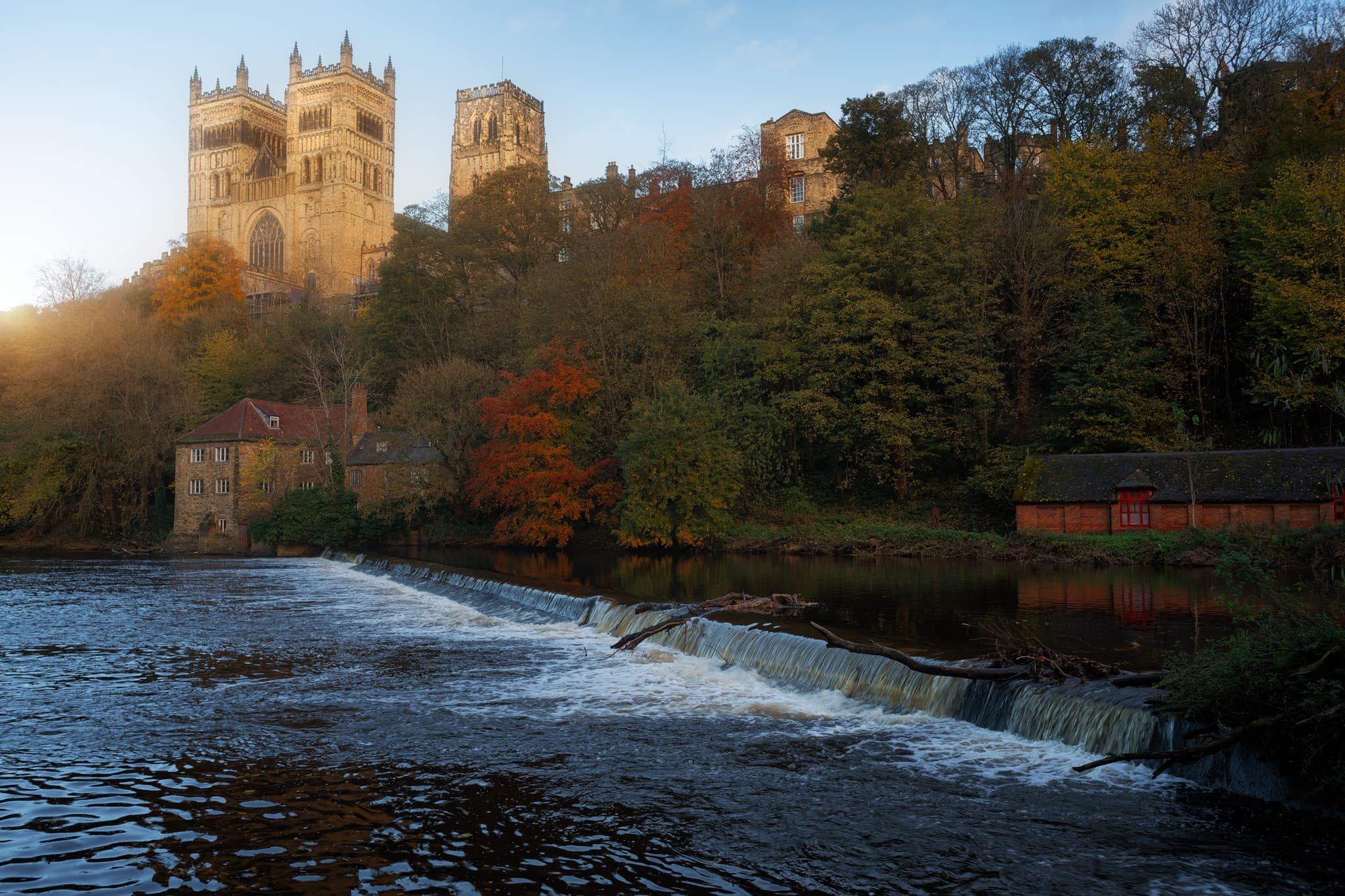
A weir at the River Wear. Clear and low autumnal light makes Durham’s buildings glow gold.
I moved into the shadows on Saddler Street, so I could pick out my compositions where the golden autumnal light was landing in interesting places. Saddler Street is one of Durham’s older roads, originally called Saddlergate.
Branching off Saddler Street is Elvet Bridge. There are numerous little “vennels”, or alleyways, that branch off Elvet Bridge. This was, Drury Lane, was home to a particularly picturesque cafe that we stopped for a brew at. I had to record this ridiculously timeless scene.
Soon we headed towards our main destination of the day: the massive Durham Cathedral, standing tall since the 11th century.
You enter the cathedral first via the Galilee Chapel. Constructed in 1170 CE, this part of the cathedral now serves as the resting place of St. Bede. Saint Bede (673-735) was an English monk and scholar renowned for his work Historia ecclesiastica gentis Anglorum, which provides invaluable insight into the history of Britain and the spread of Christianity among the Anglo-Saxon tribes.
After sorting out our entrance, we paid for the tower climb. Here you can ascend all 325 steps, 218 ft, to enjoy some immense views over Durham. I felt like a drone taking these photos! This is the view looking east.
The other side of the Central Tower gave us more extensive views looking west, pops of autumn colour here and there.
The nave of the cathedral, with its central ribbed vault obscured by the lighting fixtures assembled for an upcoming light show. The nave wouldn’t have looked much different compared to 900 years ago, except their wouldn’t be any seating.
Home to the Cathedra, the choir stalls, the organ, and the high altar, the Quire is where daily worship takes place.
This is the South Transept, from where you would access the Central Tower and climb its 325 steps. It features the Prior’s clock, constructed by Prior Castell in the late 15th or early 16th century.
The High Altar in the Quire. This would’ve been one of the earliest parts of cathedral to be constructed. Monks in the 11th century were seeking a place to hide from Vikings raids as they carried the relics of Saint Cuthbert.
The Chapel of the Nine Altars, built in the 13th century to accommodate the increasing number of pilgrims visiting the cathedral. Since St. Cuthbert’s shrine was seated here, Durham Cathedral has been an important place of worship for Christian pilgrims for centuries.
The Bishop’s Throne, built by Bishop Thomas Hatfield in the 14th century, with his tomb below it.
The light and stained glass windows around the Chapel of the Nine Altars was just astounding.
From around the Cloister, made more famous in modern times as one of the filming sets in the Harry Potter movies.

This is the Monks’ Dormitory, completed around 1404, and nowadays is home to the Cathedral Library, part of Durham Cathedral Museum. This was originally built as sleeping quarters for the Durham Priory monks.
The museum was truly fascinating and, much like the Faith Museum in Bishop Auckland, contained artefacts of faith and religious importance in the area from beyond Roman Times. This place lead to the Great Kitchen, which now houses a sacred part of the museum: Saint Cuthbert’s treasures and coffin.
Kingsgate Footbridge, completely resplendent in autumn colours. Our next goal was to locate the riverside footpath and take a wander along the river bend.
University boat racing was alive and well on the river as the sun began to set.
The woodland deep in the gorge was filled to the brim with incredible autumn colours.

From Prebends Bridge, the boat racing was in full flow, surrounded by vivid autumn foliage.
Putting Prebends Bridge in context of the river, the setting sun bursting from just above the trees.
And finally, Durham Cathedral from the riverside, catching the last of the light and glowing bright.
Did you enjoy these photos?
Bishop Auckland, County Durham, Autumn
An anniversary break.
An anniversary break.
Celebrating 11 years together, Lisabet and I enjoyed a lovely short break in County Durham area.
It’s a part of northern England that I guess can feel neglected or forgotten about. To the northwest you have the North Pennines and southwest are the Yorkshire Dales. Southeast is the North York Moors and further Northeast is the coast and Newcastle-upon-Tyne.
But there is an enormous amount of history in County Durham.
We stayed in Bishop Auckland, 10-minutes away from Durham. Bishop Auckland has a lot to offer, especially with the ongoing improvements courtesy of the ambitious Auckland Project. Upon arriving on the outskirts of the town, we head straight for its historic heart and took to exploring the Auckland Tower, the new Faith Museum, and the grounds of the castle.
We barely scratched the surface. But the just means more to explore for next time.
All photos taken on my Sony α7ii using my Pentax SMC 28mm F3.5 and Rokinon 14mm f2.8 ED AS IF UMC prime lenses. RAWs developed in Lightroom using Cobalt Image’s Fuji Classic Neg profile.
Bishop Auckland, County Durham, Autumn by Ian Cylkowski is licensed under CC BY-NC-SA 4.0![]()
![]()
![]()
![]()
Bishop Auckland Town Hall, with its unusual French-style mansard pavilions. It was opened in the mid-19th century, but by the 1970s it was abandoned then scheduled for demolition in the 1980s. Local campaigning saved the building and, after restoration work, it was reopened in the 1990s.
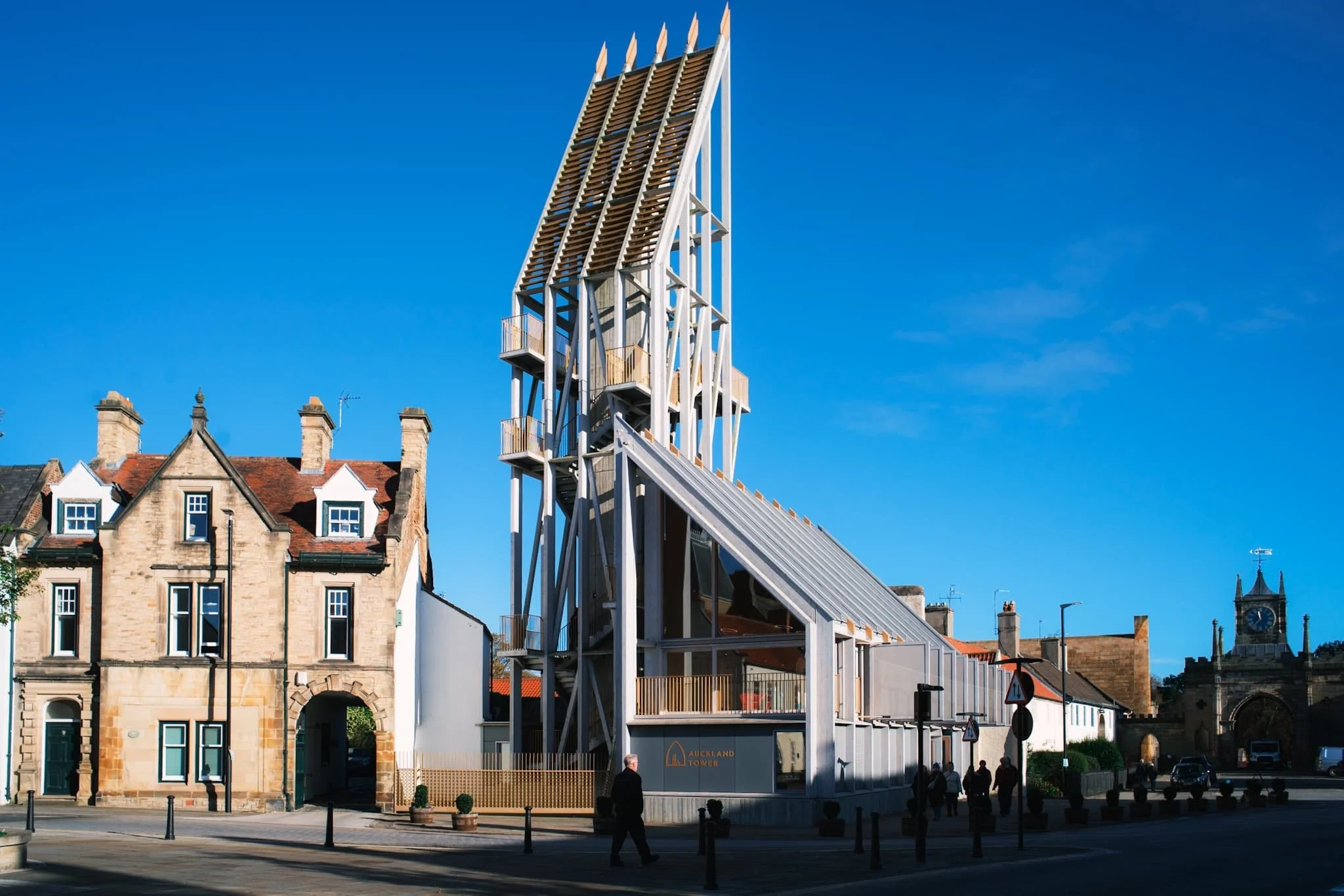
One of the new striking buildings courtesy of the Auckland Project. This is Auckland Tower. Its design is inspired by medieval wooden siege engines, which were propped against castle and fort walls to help invading armies breach defences. Adopting and inverting that same intention, the Auckland Tower borrows the design of those historic constructs to allow visitors to “breach” the castle’s history and allow people to freely explore.
A gallery on the 1st floor of the tower beautifully sets out the story and history of Bishop Auckland the surrounding area. The town was the seat of the powerful Prince Bishops of Durham since 1183 CE. Even before then, a Roman presence was in the area with a fort at nearby Binchester.
Visitors are encouraged to climb up the tower and enjoy the panoramic views on offer, which we duly did. St. Anne’s Church and the Town Hall are on the right, with the town centre through to the left.
From the top of the tower, a view to the east shows the castle gatehouse, built by Sir Thomas Robinson of Rokeby for Bishop William Trevor in 1760 CE. Beyond, the walled gardens and Auckland Park show the last of their autumnal splendour.
The grand entrance to the grounds of Auckland Castle. Inside the castle we paused for lunch in the new cafe, before seeking out the new Faith Museum.
The start of the journey into the Faith Museum. This place is fantastic, a real treasure for history geeks everywhere especially those who have an interest in the history of human faith. Being in County Durham, there is of course a lot of information about the beginnings and development of Christianity in the area, but there’s also heaps of artefacts and info about faith practised in the area during Roman times and before.
Punctuated along the main gallery were these wonderful archway tapestries that I couldn’t resist making a composition of.
Back outside, we soaked in the clear autumn air and explored the castle grounds.
We wandered around the town centre, where a different side of Bishop Auckland could be seen. Much like many other towns through the UK, the high street has seen better days. Hopefully, the Auckland Project will help rejuvenate things.
I love a pub with a mock Tudor facade. Though a pub has been on this site since the 16th century, this particular building was constructed in 1900.
Did you enjoy these photos?
Haddon Hall, Derbyshire, Autumn
Towards the end of Peak District foray, we decided it was time for something more historical.
Towards the end of Peak District foray, we decided it was time for something more historical.
Lisabet had zeroed in on a grand building near Bakewell known as Haddon Hall. It has been described as “the most complete and most interesting house of its period”. The origins of the hall are from the 11th century, with additions at various stages between the 13th and the 17th centuries, latterly in the Tudor style. Due to the building becoming uninhabited for two centuries until the 1900s, a lot of its tudor and medieval heritage has survived the modernisation of the Georgian and Victorian periods.
It’s been used extensively as a location for filming, including in Treasure Houses of Britain; The Princess Bride; the BBC's adaptation of The Silver Chair; Jane Eyre; Elizabeth; Pride & Prejudice; A Tudor Feast at Christmas; Time Crashers, and Gunpowder.
It’s definitely not a cheap place to visit, but the grounds and hall are absolutely fascinating and incredibly well preserved. I had a lot of fun with my 14mm ultra-wide lens.
All photos taken on my Sony α7ii using my Rokinon 14mm f2.8 ED AS IF UMC ultra-wide prime lens. RAWs developed in Lightroom using Cobalt Image’s Fuji Classic Neg profile.
Haddon Hall, Derbyshire, Autumn by Ian Cylkowski is licensed under CC BY-NC-SA 4.0![]()
![]()
![]()
![]()
The entrance to Haddon Hall’s Lower Courtyard. The main entrance to the Banqueting Hall, built in the 1300s, can be seen to the left.
The way in to the Banqueting Hall, where tour guides are ready to present the story and history of Haddon Hall to visitors (including us).
The main kitchen, west of the Banqueting Hall. It dates from around 1370 CE. The multiple fireplaces would’ve baked bread and spit roasted meats.
The pantry, located in between the kitchen and Banqueting Hall, also built in the 14th century. You can imagine carcasses being hung up on tenter hooks, another being butchered on the wooden slab, whilst butter was being churned elsewhere.
The Buttery, also built in the 14th century. Stone floor and walls would’ve kept the room cool enough to all manner of dairy products to be made and stored here.
The Banqueting Hall, built in 1370 CE, so it is truly medieval. It remains furnished with its original Dais table, behind which hangs a tapestry gifted to the family by a visiting Henry VIII.
The Great Chamber was a Solar or Solarium, otherwise known as "an upper chamber of a mediaeval house". It was completed between 1540 and 1567 and served as a drawing room. It has a 16th Century plaster frieze round the top of the walls, bay windows overlooking the gardens and Flemish tapestries depicting woodland scenes.
A small little study in between the Great Chamber and the Long Gallery.
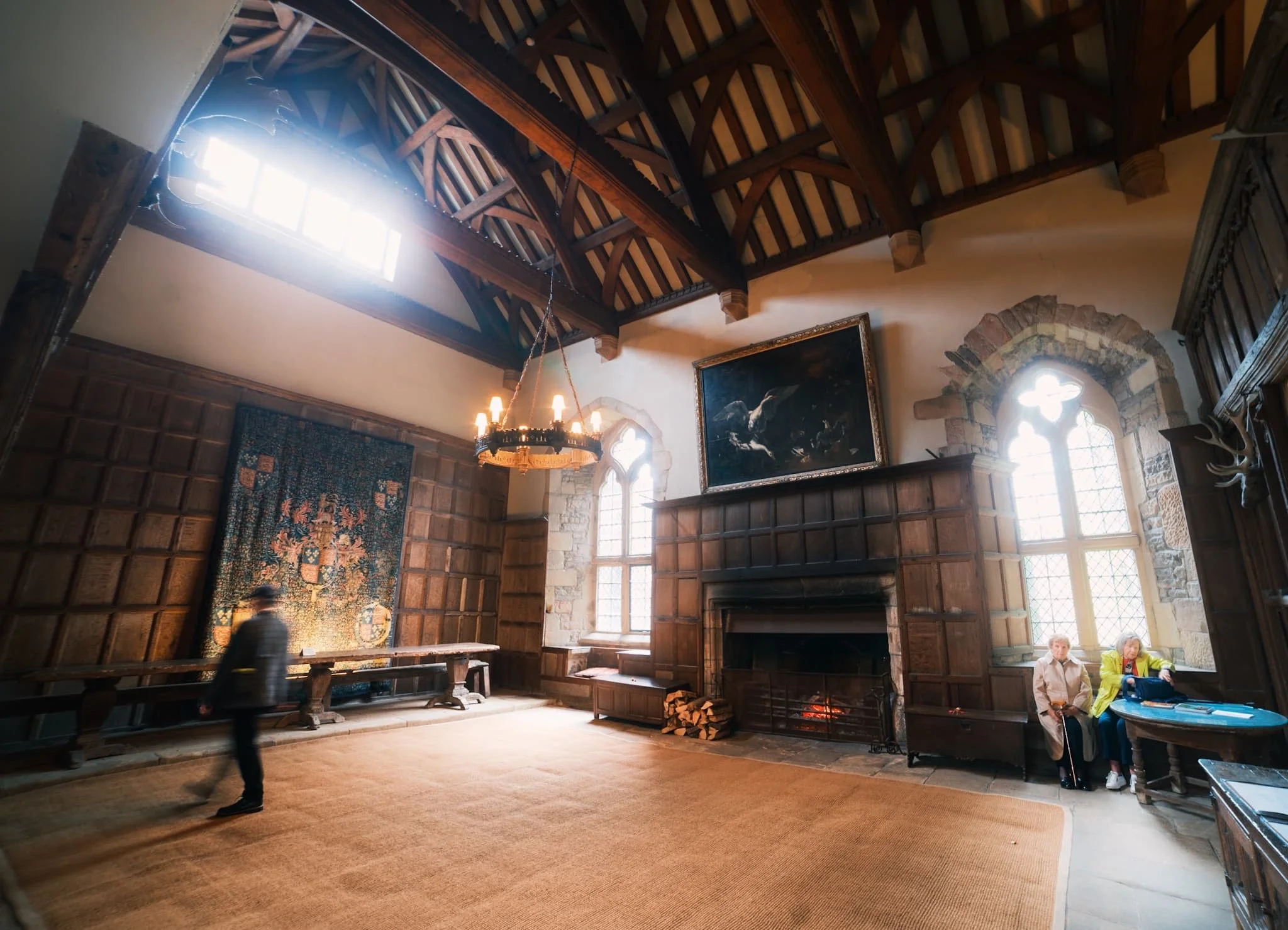
The Long Gallery of Haddon Hall, perhaps the most filmed part of the entire building. In contrast to the Tudor and Medieval Rooms below, the light and airy first floor Elizabethan rooms culminate in this spectacular 110ft Long Gallery, reputed to be one of the most beautiful rooms in England.
Above the fireplace, a painting of Haddon Hall itself, situated in the landscape. The Long Gallery dates back to about 1600 CE and its panelled walls and plaster ceiling are decorated with the coats of arms of the Vernon and Manner’s families.
The way to the Ante Room and State Bedroom. The panelling and carving above the door frame shows the Manners Peacock, standing proudly over the pediment and one of the crests.
Looking back down the Long Gallery in all its light and airy splendour.
The Ante-Room in between the Long Gallery and the State Bedroom. Tapestries decorate the walls. The walls all throughout Haddon Hall would’ve been covered in tapestries. However, the family’s most prized tapestries were stored in the stables, which is where a huge fire started in 1926, destroying most of them.
Now no longer in use as a bedroom, instead an intricately carved handmade snooker table sits in this room, decorated with tapestries and flooded with light.
The terraced 17th century gardens. Often regarded as an English interpretation of a 16th century Italian garden. Haddon Hall’s Elizabethan walled gardens are a rare survival of the 16th century.
The Hall’s walls around the gardens are covered in a wide variety of climbing roses.
Not a bad little place for a spot tea, hmm? The doorway is our next entrance, towards the Parlour.
For less formal occasions, the Parlour would be the dining room instead of the Banqueting Hall. Large windows were regarded as a costly luxury in mediaeval times. Large areas of glass could not be viably produced other than by combining smaller, often diamond-shaped, pieces held together with lead beading. These days the Parlour can be booked for weddings.
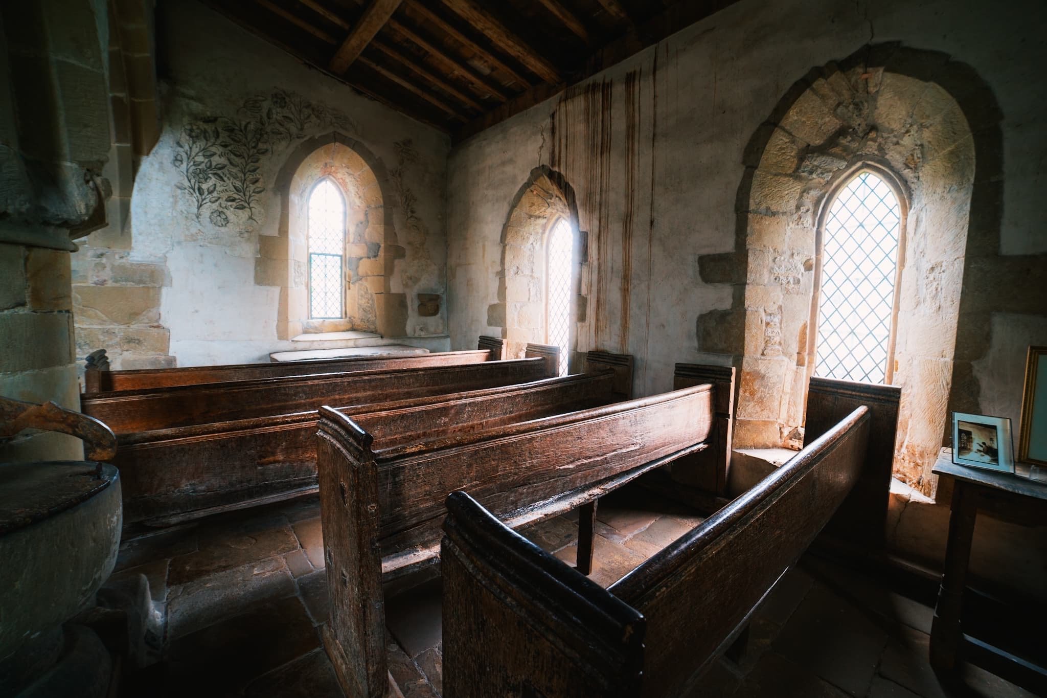
Making our way back to the Banqueting Hall, we crossed the Lower Courtyard to the Chapel of St. Nicholas. It’s a small humble building with Norman origins. The present building was finished in 1427 CE.
The chapel boasts a rare series of medieval wall paintings, most likely commissioned in the early 15th century. The paintings were whitewashed during the Reformation, but became visible in the 19th century and were restored in the early 20th century.
Exquisite and very rare 15th century fresco seccos adorn the walls of the Medieval Chapel.
One last look back across the footbridge to Haddon Hall. You can imagine a horse and cart, carrying esteemed guests, making their way towards the Hall.