
Conistone, Yorkshire Dales, Summer
Time for somewhere new.
Time for somewhere new.
The weekend was looking massively busy in Cumbria, what with the Appleby Horse Fair, Dave Day, and the Great North Swim, amongst other things. So with a cool and windy Saturday in stall, we head east once again into the Yorkshire Dales to explore somewhere new, to us: Conistone.
Conistone is a tiny idyllic village in Upper Wharfedale, across the valley from Kilnsey and its famous Kilnsey Crag. Although we’ve meandered around Grassington and Kilnsey before, we’d never ventured around the Conistone area of Upper Wharfedale. What we found were two incredible and fascinating geological wonders: Conistone Dib—a dry and steep gorge—and the Conistone Pie, an isolated limestone crag outcrop that, yes, resembles a pie.
Due to the high winds, conditions and light were changeable, which made shooting all the more challenging and fun.
And some of the views we got from around the pie were just… something else.
All photos taken on my Sony α7ii using my Sony 24-240mm F3.5-6.3 OSS zoom and Rokinon 14mm f2.8 ED AS IF UMC prime lenses. RAWs were developed in Lightroom, edited in Photomatix, and finalised in Photoshop.
Conistone, Yorkshire Dales, Summer by Ian Cylkowski is licensed under CC BY-NC-SA 4.0![]()
![]()
![]()
![]()
The centre of Conistone village, looking impossibly idyllic. A few homes here had datestones from the mid-17th century.
Heading immediately east out of the village, a footpath can be picked up that takes you up the first part of Conistone Dib, known as Gurling Trough. Delicate flowers pepper the grasses around the trail. Our excitement builds.
Thousands of years after retreating glaciers and meltwaters have finished their work, life clings on in this gorge in beautiful ways.
The gorge winds its way uphill, in increasingly tight channels. Now we’re in summer, foliage and wildflowers adorn every possible nook and cranny. Up ahead, Lisabet gawps at the stunning walls of the gorge.
The only way up and out of the gorge, a tiny person-wide chute, evidence of where prehistoric water would’ve raged through this gorge.
Looking back down the chute, I picture in my mind how gallons of water would’ve created enormous forces as it was squeezed through this tiny gap.
After popping out from the squeeze at Gurling Trough, you are presented with this glorious view of the dry valley of Conistone Dib. To the right is the imposing crag of Bull Scar.
Further up the valley our next squeeze presents itself. A characteristic drystone wall acts as a leading line all the way towards the next gorge.
Halfway up the dry gorge of Conistone Dib. An old drystone wall leads the way up, as does the ankle-breaking loose limestone scree.
Near the top, Lisabet stops to photo some flora that her eagle-eye spotted. Two trees act as a kind of “gateway”, marking and maybe even guarding the exit.
We scramble our way up and out of the gorge, but not before I turn back around and nab this composition from behind one of the “guardians”, using them to frame the gorge back downstream.
From the top of the Dib, looking perilously down to the gate and the dry gorge below that we scrambled up.
From above the Dib, multiple trails criss-cross each other towards a multitude of destinations. We took a small diversion around the top of the gorge, and found this stunning composition of Conistone Dib gorge, with the Upper Wharfedale fells beyond.
Our next destination was to find the Conistone Pie. From the Dib, it didn’t take long to locate and follow the path northeast. We soon clambered towards the Pie, and I immediately scouted around its circumference, snapping compositions of its wonderful limestone crags with views towards the far reaches of Upper Wharfedale.
The views from the top of Conistone Pie! Not bad, eh?
My 24-240 mm zoom lens allowed me to really zoom in tight and crop in on these more intimate landscapes my eye can spot.
Another long zoom composition, showing the characteristic upland fell farming landscape of the Yorkshire Dales; land parcelled off with drystone walls. I waited as slivers of golden light scanned across the landscape, and picked my moment when the foreground barn was illuminated.
From the top of the Pie you can even make out, across the valley, the impressive sheer face of Kilnsey Crag, a famous and challenging climb.
At the full 240 mm zoom, I pick out the farthest reaches of Upper Wharfedale as golden evening light scans across the dale.
Before descending back down towards the village, I sought a composition that “described” the Conistone Pie well. This was the best I could do. You can see why it’s called a pie!
From the pie we retraced our steps towards the top of Conistone Dib and located the main path, called Scot Gate Lane, which takes you all the way back down to the village. Along the way, lambs and their mums bleat and scamper away from us, but not before I was able to zoom in and capture this timeless scene.
Nearing the bottom of Scot Gate Lane, an unusual yet welcome and unfortunately rare cacophony of sounds surrounded us: Curlews! I had never heard so many. As they cried and whistled around us, the low evening low picked out this incredible scene of Conistone Dib and the valley floor of Upper Wharfedale.
Back at the village, the evening light drenches the old buildings in soft amber.
Did you enjoy these photos?

Sedbergh, Yorkshire Dales, Summer
It’s summer! Y’know what that means? Wild flower meadows.
It’s summer! Y’know what that means? Wild flower meadows.
We’re rather fortunate to live where we do, sandwiched between abundant nature. You can take your pick of beautiful places to see wildflower summer meadows. A particular favourite is Swaledale in the Yorkshire Dales.
But I can also recommend the Sedbergh meadows underneath the Howgills.
We usually start this hike from Sedbergh town itself, but this time we started from Straight Bridge, walking away rather than into the sun.
Sedbergh is pretty enough anyway, but in the summer it becomes positively idyllic. And the meadows around the town were filled with wildflowers.
All photos taken on my Sony α7ii using my Sony 24-240mm F3.5-6.3 OSS zoom and Rokinon 14mm f2.8 ED AS IF UMC prime lenses. RAWs developed in Lightroom, edited in Photomatix and Photoshop.
Sedbergh, Yorkshire Dales, Summer by Ian Cylkowski is licensed under CC BY-NC-SA 4.0![]()
![]()
![]()
![]()
Following the path alongside the River Rawthey, a beautiful field full of buttercups stopped us in our tracks.
So did these mushrooms. These are possibly Dryad’s Saddle, or Cerioporus squamosus.
A Kendal Rough Fell yow enjoying the summer sun in the meadows.
A pair of geese, following each other around the fields.
New Bridge, which is quite a funny name given that it was built in the 1700s. A lush scene framing this gorgeous structure.
There’s plenty of horses about at the moment as travellers make their way to the Appleby Horse Fair. One particularly shaggy fella posed for me in a field full of flowers, and I couldn’t say no.
After a brief pit stop and refreshment in Sedbergh town, we continued the hike. The trail circumnavigates Castlehaw and climbs up the hillside underneath the Howgills. A very dry Settlebeck Gill provides a leading line in between these gnarly old trees.
Out into the open, fields full of flowers surrounded us. Passing clouds temporarily darkened the summit of Knott, whilst sheep and their lambs happily graze on the meadows below.
Further along the trail, a field of curious bullocks idly stare at us as we made our way towards Ghyll Farm.
Just before you reach Ghyll Farm the trail narrows into a beautiful little lane, surrounded by hedgerows and old trees. It created a natural frame that I made a composition of.
Beyond Ghyll Farm, you continue southeast towards Stone Hall, a Grade II* listed building. Formerly a farmhouse, it dates from 1695.
Between Stone Hall and Ellerthwaite, the wildflower meadows just got better and better. One particular field was absolutely chock full of them. I nabbed a shot of Lisabet admiring the buttercup fields, a timeless scene.
We spotted this old tree, host to a load of bracket fungi, so I equipped my ultra-wide lens in order to make a composition of the tree, the fungi, the buttercup meadow and the Howgills. Success!
The cloud cover was beginning to thicken, but pockets of sun still broke through. A distant scene looking south towards the Dent fells made me zoom right in.
At Ellerthwaite we came across this magnificent field full of buttercups. I spotted these tracks winding through the field and waited for the sun to burst through, illuminating the field whilst the distant hills darkened under the clouds.
Beyond Buckbank the trail follows the trees above the River Rawthey back to Straight Bridge. Another beautiful meadow lined with farm tracks, with Lisabet ahead, gave me my final composition.
Did you enjoy these photos?

Oxenber & Wharfe Woods, Yorkshire Dales, Spring
It’s been nearly a month since my last post.
It’s been nearly a month since my last post.
I must apologise for that. Times, they are a’ changin’.
To start, we moved house! That in itself has consumed most of my time and energy, as house moves usually do. Thankfully we’re now all settled in and getting down to the important things in life, like looking at curtain textiles and measuring all the things.
With things settling back down a little, and the British weather drastically improving, we thought we’d try to capture the last of this year’s bluebells. Over the years we’ve found some proper lovely places to photograph bluebells, such as:
This time we tried somewhere new, to us, based on personal recommendation: the woods of Oxenber and Wharfe near Feizor.
And we were absolutely blown away.
Carpets of bluebells, some in ancient woodland, some out in the open with spectacular views to the likes of Moughton Scar and Ingleborough.
Happily, this was also my first full outing with my newly acquired Sony 24-240mm F3.5-6.3 OSS, courtesy of my Dad. This lens easily replaced five other lenses I had, which has significantly reduced my carrying load.
I hope you enjoy these photos as much as I enjoyed taking and editing them.
All photos shot on my Sony α7ii using my Sony 24-240mm F3.5-6.3 OSS zoom lens. RAWS edited in Lightroom, edited in RNI Films, and finalised in Photoshop.
Oxenber & Wharfe Woods, Yorkshire Dales, Spring by Ian Cylkowski is licensed under CC BY-NC-SA 4.0![]()
![]()
![]()
![]()

Our hike started from Austwick and we were soon on the easy well-defined trail towards the elevated Oxenber and Wharfe woods.
A beautiful Holstein Friesian lady, basking in the glorious sunshine.
We followed Wood Lane as the trail started to ascend. Looking back across the segmented fields towards Robin Proctor’s Scar and the Norber Erratics.
The signage was clear enough as to where we needed to go.
Soon enough we began the short and sharp ascent off Wood Lane and into Oxenber Wood. Bluebells everywhere.
This area of woodland and pasture was once an important quarry and source of timber for Austwick. Now it’s marked as an SSSI and largely left to its own devices.
Open areas of former pasture meant acres of bluebells, out in the open, enjoying views towards the likes of Moughton Scar and Ingleborough.
A carpet of bluebells with Moughton Scar on the left and Bargh Hill on the right.
Higher up, more former pasture land has given way to more bluebells. I found this solitary limestone boulder covered in moss that made for a lovely composition.
In addition to all the bluebells were tracts of limestone pavement, much to my delight!
Entering the denser woodland of Wharfe wood, a small trail branched off, giving views towards Moughton Scar.
Wharfe wood’s thicker coverage meant for beautiful soft light and trees covered in moss and lichen.
A small trail heads deeper into Wharfe Wood, with a hint of yet more bluebells beyond. Our route was to exit out of the eastern end of the woodland, but not before I chanced upon this mystical scene.
Popping out of Wharfe Wood, the unmistakable shape of Pen-y-ghent quickly makes itself known to us.
The route now followed the Pennine Bridleway towards Feizor. To the left are the shoulders of the limestone hills above Feizor.
This year’s spring lambs, of the Swaledale kind, quickly scampered to their mums.
On our descent to Feizor I spotted this little cottage and its field covered in buttercups.
The rest of the route back to Austwick was simple enough, just follow the Pennine Bridleway from Feizor to Austwick. This ancient country lane was lined with wild garlic (Allium ursinum) and its delicious smell.
The collapsed ruins of Meldings Barn, with a doorway still standing on its own.
Back at Austwick, the local cows gently made their way to Austwick Beck for a cool down and a drink to relieve from the warm spring day.
Did you enjoy these photos?

Feizor, Yorkshire Dales, Spring
I don’t explore the Yorkshire Dales enough.
I don’t explore the Yorkshire Dales enough.
After finally getting over my post-Skye mourning and depression period, it seemed like spring finally arrived in Northern England.
Aware of how busy the Lake District would be, we instead ventured east to the Yorkshire Dales. We quickly realised that we hadn’t explored the Feizor area of the Dales in a long time, like maybe 7-years or so. Time to fix that.
Feizor (pronounced “FAY-zer”) is a tiny l’al hamlet between Austwick and Settle, and easy to miss. Home to a few houses, a farm, and the famous Elaine’s Tearoom, rising high above the hamlet are the limestone fells of Pott Scar and Smearsett Scar. These were the focus of the day’s hike and exploration.
Pott Scar and Smearsett Scar were beautiful examples of limestone karst landscapes, but they also offered immense views to either the back of Ingleborough or the shapely Pen-y-ghent.
A super day.
All photos taken on my Sony α7ii using my Sony FE 28–70mm f3.5–5.6 OSS and Vivitar “Series 1” 70–210mm f2.8–4.0 zoom lenses. RAWs developed in Lightroom, then tweaked and finalised in Photoshop.
Feizor, Yorkshire Dales, Spring by Ian Cylkowski is licensed under CC BY-NC-SA 4.0![]()
![]()
![]()
![]()
A near-timeless scene in the heart of Feizor. Old stone buildings, dry stone walls, foliage everywhere, and the fells rising up behind.
This quaint scene, complete with old water pump, was something I couldn’t resist making a composition of.
Round the back of Pott Scar, before ascending, one can enjoy expansive views towards Pen-y-ghent, one of the Three Peaks of the Yorkshire Dales.
The squelchy slog up the fell was rewarded with beautiful views from Pott Scar towards Smearsett Scar.
Fin-like clints and grikes of limestone made for a nice leading line towards Smearsett Scar.
Nearer the edge of Pott Scar, I focus stacked these bare limestone edges as they curved off into the distance towards Smearsett Scar.
From the summit of Smearsett Scar, the full extent and shape of Pott Scar is revealed. The day was brightening up too, albeit with a haze.
The summit of Smearsett Scar offers a bounty of limestone clints and grikes that I want to make compositions of.
Another variation from the summit of Smearsett Scar, using the exposed clints and grikes as a leading line towards Pott Scar.
Back down the back of Pott Scar, drafting clouds cast dancing shadows across Moughton Scar and the back of mighty Ingleborough, another one of the Three Peaks of the Yorkshire Dales.
Plenty of teeny Swaledale lambs about, hastily retreating back to their mums as we followed the track back to Feizor.
The single road that winds its way through Feizor.
A super-zoomed in composition of the back of Ingleborough, taken from the small lane between Feizor and Buck Haw Brow, light dancing across the karst features of the land.
Did you enjoy these photos?

Hull Pot, Yorkshire Dales, Winter
A month since my last post.
A month since my last post.
I do apologise.
The weather in January has been, well, shocking to say the least. We endured three named storms: Henk, Isha, and Jocelyn. Isha, in particular, was one of the most powerful storms the British Isles have seen since 2000.
Additionally, we’ve had periods of below freezing temperatures, resulting in widespread ice.
It’s been… interesting.
Thankfully, the weekend just gone, it was nice enough for us to finally head out. We chose the Hull Pot route from Horton-in-Ribblesdale in the Yorkshire Dales. I had an inkling that there’d still be some snow liggin’ about in the Dales, contributing to a water-saturated landscape and, hopefully, a waterfall flowing into Hull Pot.
And we finally saw it.
All photos taken on my Sony α7ii using my Pentax SMC 28mm F3.5, Pentax SMC 55mm f2.0, and Rokinon 14mm f2.8 ED AS IF UMC prime lenses. RAWs developed in Lightroom, edited and finalised in Photoshop.
Hull Pot, Yorkshire Dales, Winter by Ian Cylkowski is licensed under CC BY-NC-SA 4.0![]()
![]()
![]()
![]()
The characteristic drystone walls of the Yorkshire Dales remained steadfast in the face of all the snow we’ve had recently, resulting in these snowdrifts piled up against them.
Our way forward. We knew on this day that there’d only be 2-3 hours of good light, and boy was it dramatic.
Looking back at where we came from. We were very much on the edge of two weather systems. Conditions over Horton-in-Ribblesdale saw blue skies and puffy clouds, but closer to Pen-y-Ghent it was blowy, dark, and stormy, giving us epic light.
A good sign: A small waterfall where there usually isn’t at Horton Scar. Above, Pen-y-Ghent fights with the dark and stormy clouds.
Further up the bridleway, the site of an extinct waterfall below Pen-y-Ghent, which is now obscured by clouds laden with snow. A burst of sun to our right picks out the details in the land.
And there she is, finally ticked off my bucket list. England’s largest natural hole, Hull Pot, with Hull Pot Beck tumbling down 60ft into the chasm. As mentioned before on this blog, Hull Pot is a large cave where the roof has collapsed, which has resulted in this massive chasm below Pen-y-Ghent. With my ultra-wide 14mm equipped, I was able to capture the entire scene.
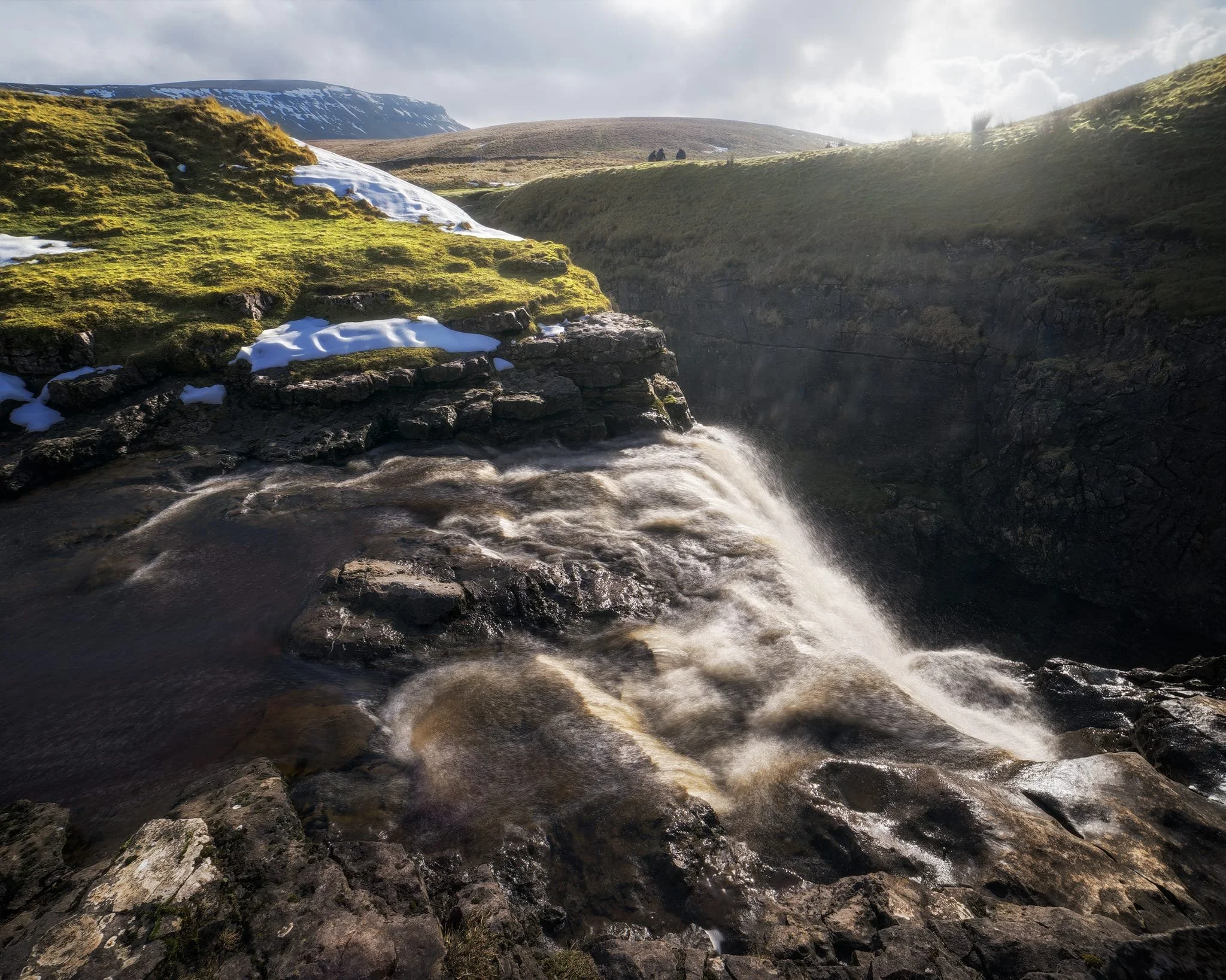
We clambered as close to the waterfall as possible as it crashed over the edge into Hull Pot. As I had no tripod, I shot this with my ultra-wide 14mm at f/22, taking multiple exposures of the same scene. In post, I then averaged the exposures together that gave me that long exposure effect on the water.
Looking up Hull Pot Beck and its many cascades. By the normal way of things, this beck is dry as it usually disappears into the maze of caves beneath Pen-y-Ghent before it reaches Hull Pot. With all the rain and snow we’ve had, the beck was able to complete its route, crashing 60ft down into Hull Pot and re-emerging at the surface nearer Horton-in-Ribblesdale.
A different view of Hull Pot from its eastern end. Two boulders balance precariously on the lip of the pot.
At around 450 m/1,476 ft above sea level, a few snow patches have lingered around the edges of Hull Pot, allowing for some interesting compositional leading lines.
A particularly clean snow patch nearer the falls gives me an idea for a composition involving Pen-y-Ghent in the distance. Fellow hikers milling about the edge of Hull Pot give you a sense of scale of this place.
Heading back down to the village, signs were clear that the best of the day’s light were done as the storm clouds rolled in. We were thankful to get what we did, though.
Did you enjoy these photos?
Grassington, Yorkshire Dales, Autumn
Autumn is coming.
Autumn is coming.
Knowing that yet more rain was on its way in the afternoon, and that our best chances were further east, we elected to head into the Yorkshire Dales. Here we embarked on a nice 10 km hike, taking in the epic Linton Falls, timeless Grassington, and Grass Wood Nature Reserve.
While there were certainly hints of autumn colours, it seems we need another couple of weeks around our latitude before they reach peak conditions. That’s assuming, of course, that the weather cooperates and doesn’t just blow all the leaves straight off the trees.
Although strictly speaking a town, Grassington has a wonderfully timeless Yorkshire village vibe. As a result, it was selected as the primary location for the 2020 reboot of All Creatures Great and Small, playing the role of the fictional Yorkshire town of Darrowby.
All photos shot on my Sony α7ii using my Sony FE 28–70mm f3.5–5.6 OSS zoom lens. RAWs were largely developed using Capture One for iPad, and finalised using Lightroom for iPad and Darkroom for iPad.
Grassington, Yorkshire Dales, Autumn by Ian Cylkowski is licensed under CC BY-NC-SA 4.0![]()
![]()
![]()
![]()
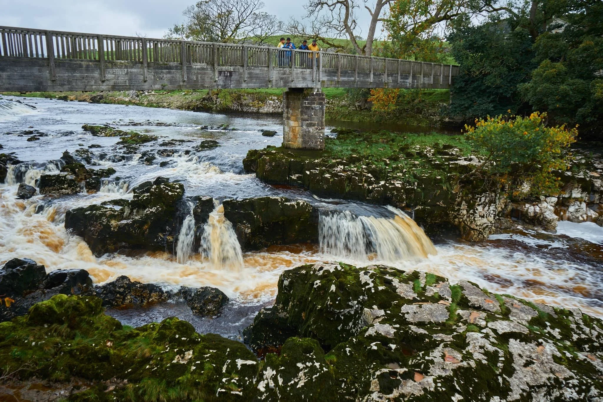
Linton Falls, a series of powerful cascades crashing over a limestone fault in the River Wharfe.
Just above the falls are a couple of weirs that sweep across the river, disrupting the flow of water so as not to sweep away at the river bank so much.

My Lisabet on the footbridge above the thundering falls. It’s quite the drop and a somewhat unnerving sensation.
From the footbridge looking down, it’s easy to make out the fault. Here, a prehistoric seismic shift in the earth will have uplifted some of the limestone in the river bed higher than the rest, creating these cascades and limestone platforms.
Looking upstream, you can make out the second weir and Linton Falls Hydro. There’s been a hydroelectric power station here since 1909, but was closed down in 1948. Decades later, in 2012, the building came back into use once again as a hydroelectric generating power station, modified to minimise harm on nature and local wildlife.
Beyond the footbridge we took the ancient Sedber Lane up the fellside towards Grassington. Looking back down offers an enchanting, if moody, Yorkshire Dales scene.
Grassington. Mentioned in the Domesday Book of 1086 CE, the village was originally documented as Gherinstone, Garsington, or Gersington. The name is a mix of Old Norse and Old English, meaning either “the town of the grassy ings” or a “farmstead surrounded by grass.”
Stopping for some coffee and cake, we then wandered gently around the village documenting some of the more timeless scenes Grassington had to offer (save, of course, for all the vehicles unceremoniously dumped everywhere).
A lot of old architecture in Grassington has survived remarkably well, aiding the village’s “ye olde worlde” appeal.
Bunting zigzagged across the skyline above us as we made our way up the higher parts of Grassington.
The Black Horse Hotel. Originally built in the 17th century as a coaching inn, it saw additions and alterations in the 18th and 19th centuries.
Above the Black Horse Hotel, we continued up Garrs Lane. Save for the road markings, you could easily transport your mind back several centuries, looking at this scene.
A beautiful cottage with window shutters. To the right an old resident had just finished tending to a beautiful garden.
Right near the junction of Main Street, Garrs Lane, and Moor Lane, this wonderful shop—Ashton House Crafts & Carving—was busy displaying all its various sculptures, carvings, and wood chimes. Just delightful.
Chamber End Fold has maintained its cobbled street, helping to cement this ageless Yorkshire scene (if we carefully ignore the car).
We continued up north out of Grassington, taking the ancient Bank Lane onto the Dales High Way and west towards Grass Wood Nature Reserve. Old stone barns decorate the way towards the woods.
These little pops of autumn hues were a tantalising prospect of what is to come.
Grass Wood Nature Reserve is one of the largest broadleaved woodlands in the Dales, comprised primarily of ash woodland interspersed with limestone scars. We followed the minor trail alongside Gregory Scar, thick in the woods.
A delicate little scene, showing the beginnings of those beautiful autumnal colours.
Nearing the exit, this part of the woods was carpeted in fallen autumnal foliage.
Nearing Grassington via Grass Wood Lane, one final composition arrested my attention near the cricket grounds.